FAA INFORMATION EFFECTIVE 19 MARCH 2026
Location
| FAA Identifier: | AYS |
| Lat/Long: | 31-14-54.2000N 082-23-43.4000W
31-14.903333N 082-23.723333W
31.2483889,-82.3953889
(estimated) |
| Elevation: | 141.3 ft. / 43.1 m (surveyed) |
| Variation: | 05W (2005) |
| From city: | 3 miles NW of WAYCROSS, GA |
| Time zone: | UTC -4 (UTC -5 during Standard Time) |
| Zip code: | 31503 |
Airport Operations
| Airport use: | Open to the public |
| Activation date: | 04/1940 |
| Control tower: | no |
| ARTCC: | JACKSONVILLE CENTER |
| FSS: | MACON FLIGHT SERVICE STATION |
| NOTAMs facility: | AYS (NOTAM-D service available) |
| Attendance: | M-F 0700-1900 |
| Wind indicator: | lighted |
| Segmented circle: | yes |
| Lights: | DUSK-2200; AFTER 2200, ACTVT MALSR RWY 19; REIL RWY 19; PAPI RWY 01 & 19; HIRL RWY 01/19 - CTAF. |
| Beacon: | white-green (lighted land airport)
Operates sunset to sunrise. |
Airport Communications
| CTAF/UNICOM: | 122.8 |
| WX AWOS-3: | 118.575 (912-287-4466) |
| WX ASOS at AMG (18 nm N): | 118.325 (912-632-8738) |
- APCH/DEP SVC PRVDD BY JACKSONVILLE ARTCC ON FREQS 127.575/269.025 (ALMA RCAG) .
Nearby radio navigation aids
| VOR radial/distance | | VOR name | | Freq | | Var |
|---|
| AYSr099/8.4 | | WAYCROSS VORTAC | | 112.40 | | 00E |
| NDB name | | Hdg/Dist | | Freq | | Var | | ID |
|---|
| WIKET | | 183/4.6 | | 219 | | 05W | | AY | .- -.-- |
Airport Services
| Fuel available: | 100LL JET-A+
100LL:FOR FUEL AFTER HRS CALL 912-287-4335. |
| Parking: | hangars and tiedowns |
| Airframe service: | NONE |
| Powerplant service: | NONE |
| Bottled oxygen: | NONE |
| Bulk oxygen: | NONE |
Runway Information
Runway 1/19
| Dimensions: | 5992 x 100 ft. / 1826 x 30 m |
| Surface: | asphalt, in good condition |
| Weight bearing capacity: | | Single wheel: | 45.0 | | Double wheel: | 70.0 |
|
| Runway edge lights: | high intensity |
| RUNWAY 1 | | RUNWAY 19 |
| Latitude: | 31-14.336595N | | 31-15.324825N |
| Longitude: | 082-23.887785W | | 082-23.902983W |
| Elevation: | 133.9 ft. | | 139.0 ft. |
| Traffic pattern: | left | | left |
| Runway heading: | 004 magnetic, 359 true | | 184 magnetic, 179 true |
| Markings: | precision, in fair condition | | precision, in fair condition |
| Visual slope indicator: | 2-light PAPI on left (3.00 degrees glide path) | | 2-light PAPI on left (3.00 degrees glide path) |
| Approach lights: | | | MALSR: 1,400 foot medium intensity approach lighting system with runway alignment indicator lights |
| Runway end identifier lights: | | | yes |
| Touchdown point: | yes, no lights | | yes, no lights |
| Instrument approach: | | | ILS |
| Obstructions: | 70 ft. trees, 1321 ft. from runway, 520 ft. left of centerline, 16:1 slope to clear | | 97 ft. trees, 1896 ft. from runway, 752 ft. left of centerline, 17:1 slope to clear |
Runway 5/23
| Dimensions: | 5044 x 100 ft. / 1537 x 30 m |
| Surface: | asphalt, in good condition |
| Weight bearing capacity: | |
| RUNWAY 5 | | RUNWAY 23 |
| Latitude: | 31-14.591632N | | 31-15.206730N |
| Longitude: | 082-23.989228W | | 082-23.337048W |
| Elevation: | 140.2 ft. | | 136.3 ft. |
| Traffic pattern: | left | | left |
| Runway heading: | 047 magnetic, 042 true | | 227 magnetic, 222 true |
| Markings: | basic, in good condition | | basic, in good condition |
| Touchdown point: | yes, no lights | | yes, no lights |
| Obstructions: | 80 ft. trees, 1257 ft. from runway, 200 ft. right of centerline, 13:1 slope to clear | | 69 ft. trees, 1270 ft. from runway, 74 ft. left of centerline, 15:1 slope to clear |
Runway 13/31
| Dimensions: | 3554 x 75 ft. / 1083 x 23 m |
| Surface: | asphalt, in good condition |
| Weight bearing capacity: | |
| RUNWAY 13 | | RUNWAY 31 |
| Latitude: | 31-15.213158N | | 31-14.849728N |
| Longitude: | 082-23.789850W | | 082-23.254368W |
| Elevation: | 140.6 ft. | | 137.8 ft. |
| Traffic pattern: | left | | left |
| Runway heading: | 133 magnetic, 128 true | | 313 magnetic, 308 true |
| Markings: | basic, in fair condition | | basic, in good condition |
| Touchdown point: | yes, no lights | | yes, no lights |
| Obstructions: | none | | 53 ft. trees, 1260 ft. from runway, 200 ft. right of centerline, 20:1 slope to clear |
Airport Ownership and Management from official FAA records
| Ownership: | Publicly-owned |
| Owner: | WARE COUNTY
800 CHURCH STREET, SUITE 223
WAYCROSS, GA 31501
Phone 912-287-4300 |
| Manager: | DEE MEADOWS
3098 KEEN DRIVE
WAYCROSS, GA 31503
Phone 912-337-1462 |
Additional Remarks
| - | 1089 FT TOWER 9.5 NM WEST OF ARPT. |
| - | FOR CD CTC JACKSONVILLE ARTCC AT 904-845-1592. |
Instrument Procedures
NOTE: All procedures below are presented as PDF files. If you need a reader for these files, you should download the free Adobe Reader.NOT FOR NAVIGATION. Please procure official charts for flight.
FAA instrument procedures published for use from 19 March 2026 at 0901Z to 16 April 2026 at 0900Z.
IAPs - Instrument Approach Procedures |
|---|
| ILS Y OR LOC Y RWY 19 | |
download (267KB) |
| ILS Z OR LOC Z RWY 19 | |
download (306KB) |
| RNAV (GPS) RWY 01 | |
download (264KB) |
| RNAV (GPS) RWY 19 | |
download (279KB) |
| VOR-A | |
download (228KB) |
| NOTE: Special Alternate Minimums apply | |
download (167KB) |
| NOTE: Special Take-Off Minimums/Departure Procedures apply | |
download (288KB) |
Other nearby airports with instrument procedures:
KAMG - Bacon County Airport (18 nm N)
KHOE - Homerville Airport (23 nm SW)
4J1 - Brantley County Airport (25 nm E)
KDQH - Douglas Municipal Airport (27 nm NW)
KBHC - Baxley Municipal Airport (28 nm N)
|
|

Road maps at:
MapQuest
Bing
Google
| Aerial photo |
|---|
WARNING: Photo may not be current or correct

Do you have a better or more recent aerial photo of Waycross-Ware County Airport that you would like to share? If so, please send us your photo.
|
| Sectional chart |
|---|
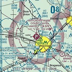
|
| Airport distance calculator |
|---|
|
|
| Sunrise and sunset |
|---|
|
Times for 23-Mar-2026
| | Local
(UTC-4) | | Zulu
(UTC) |
|---|
| Morning civil twilight | | 07:06 | | 11:06 |
| Sunrise | | 07:31 | | 11:31 |
| Sunset | | 19:42 | | 23:42 |
| Evening civil twilight | | 20:06 | | 00:06 |
|
| Current date and time |
|---|
| Zulu (UTC) | 23-Mar-2026 10:03:02 |
|---|
| Local (UTC-4) | 23-Mar-2026 06:03:02 |
|---|
|
| METAR |
|---|
| KAYS | 230955Z AUTO 00000KT 7SM BKN006 16/15 A3000 RMK AO2 T01610151
|
KAMG
18nm N | 230953Z AUTO 23005KT 8SM CLR 16/15 A2998 RMK AO2 SLP150 T01560150
|
|
| TAF |
|---|
KVAD
45nm W | 230800Z 2308/2414 25009KT 9999 BKN006 510006 QNH3002INS BECMG 2312/2313 25009KT 9999 BKN010 510006 QNH3005INS BECMG 2313/2314 25009KT 9999 SKC 510006 QNH3005INS BECMG 2317/2318 27010G20KT 9999 SCT050 510006 QNH3001INS BECMG 2401/2402 35006KT 8000 -RA BKN035 BKN250 510006 QNH3002INS BECMG 2405/2406 35006KT 9999 NSW OVC050 510006 QNH3005INS BECMG 2411/2412 07010G15KT 9999 BKN050 BKN210 510006 QNH3014INS TX30/2322Z TN15/2312Z
|
|
| NOTAMs |
|---|
NOTAMs are issued by the DoD/FAA and will open in a separate window not controlled by AirNav.
|
|


