FAA INFORMATION EFFECTIVE 19 MARCH 2026
Location
| FAA Identifier: | BBB |
| Lat/Long: | 45-19-54.9000N 095-39-02.1000W
45-19.915000N 095-39.035000W
45.3319167,-95.6505833
(estimated) |
| Elevation: | 1039.3 ft. / 316.8 m (surveyed) |
| Variation: | 05E (1985) |
| From city: | 2 miles W of BENSON, MN |
| Time zone: | UTC -5 (UTC -6 during Standard Time) |
| Zip code: | 56215 |
Airport Operations
| Airport use: | Open to the public |
| Activation date: | 06/1949 |
| Control tower: | no |
| ARTCC: | MINNEAPOLIS CENTER |
| FSS: | PRINCETON FLIGHT SERVICE STATION |
| NOTAMs facility: | BBB (NOTAM-D service available) |
| Attendance: | UNATNDD |
| Wind indicator: | lighted |
| Segmented circle: | yes |
| Lights: | MIRL RY 14/32 PRESET LOW INTST TO INCR INTST AND ACTVT REIL RY 14/32; PAPI RY 14//32; MIRL RY 14/32 - CTAF. |
| Beacon: | white-green (lighted land airport)
Operates sunset to sunrise. |
Airport Communications
| CTAF/UNICOM: | 122.8 |
| WX AWOS-3PT: | 118.45 (320-843-3242) |
| WX AWOS-3 at AQP (16 nm SW): | 118.5 (320-289-1265) |
| WX AWOS-3PT at MOX (19 nm NW): | 118.6 (320-589-1303) |
- APCH/DEP SVC PRVDD BY MINNEAPOLIS ARTCC ON FREQS 125.5/323.1 (DARWIN RCAG).
Nearby radio navigation aids
| VOR radial/distance | | VOR name | | Freq | | Var |
|---|
| MOXr131/19.4 | | MORRIS VOR/DME | | 109.60 | | 05E |
| MVEr002/21.7 | | MONTEVIDEO VOR/DME | | 111.60 | | 05E |
| BDHr296/25.6 | | WILLMAR VOR/DME | | 113.70 | | 04E |
Airport Services
| Fuel available: | 100LL JET-A
100LL:SELF SERVE FUEL AVAIL 24 HRS WITH CREDIT CARD. |
| Parking: | hangars and tiedowns |
| Airframe service: | MINOR |
| Powerplant service: | MINOR |
| Bottled oxygen: | NONE |
| Bulk oxygen: | NONE |
Runway Information
Runway 14/32
| Dimensions: | 4000 x 75 ft. / 1219 x 23 m |
| Surface: | asphalt, in fair condition |
| Weight bearing capacity: | | Single wheel: | 40.0 | | Double wheel: | 50.0 |
|
| Runway edge lights: | medium intensity |
| RUNWAY 14 | | RUNWAY 32 |
| Latitude: | 45-20.180475N | | 45-19.651300N |
| Longitude: | 095-39.311823W | | 095-38.756712W |
| Elevation: | 1038.5 ft. | | 1038.6 ft. |
| Traffic pattern: | right | | left |
| Runway heading: | 139 magnetic, 144 true | | 319 magnetic, 324 true |
| Markings: | nonprecision, in fair condition | | nonprecision, in fair condition |
| Visual slope indicator: | 4-light PAPI on left (3.00 degrees glide path)
RY 14 PAPI UNUSEABLE BYD 2 NM. | | 4-light PAPI on left (3.00 degrees glide path) |
| Runway end identifier lights: | yes | | yes |
| Touchdown point: | yes, no lights | | yes, no lights |
| Obstructions: | 7 ft. brush, 334 ft. from runway, 139 ft. right of centerline, 19:1 slope to clear | | 33 ft. trees, 773 ft. from runway, 221 ft. right of centerline, 17:1 slope to clear |
Airport Ownership and Management from official FAA records
| Ownership: | Publicly-owned |
| Owner: | CITY OF BENSON
1410 KANSAS AVE
BENSON, MN 56215
Phone 320-843-4775 |
| Manager: | MATT SKARET
1410 KANSAS AVE
BENSON, MN 56215
Phone 320-843-4775 |
Additional Remarks
| - | CATEGORY 'C' & 'D' ACFT OPNS PROHIBITED. |
| - | FOR CD CTC MINNEAPOLIS ARTCC AT 651-463-5588. |
Instrument Procedures
NOTE: All procedures below are presented as PDF files. If you need a reader for these files, you should download the free Adobe Reader.NOT FOR NAVIGATION. Please procure official charts for flight.
FAA instrument procedures published for use from 19 March 2026 at 0901Z to 16 April 2026 at 0900Z.
IAPs - Instrument Approach Procedures |
|---|
| RNAV (GPS) RWY 14 | |
download (214KB) |
| RNAV (GPS) RWY 32 | |
download (204KB) |
| NOTE: Special Alternate Minimums apply | |
download (19KB) |
| NOTE: Special Take-Off Minimums/Departure Procedures apply | |
download (156KB) |
Other nearby airports with instrument procedures:
KAQP - Appleton Municipal Airport (16 nm SW)
KMOX - Morris Municipal Airport - Charlie Schmidt Field (19 nm NW)
KMVE - Montevideo-Chippewa County Airport (22 nm S)
KGHW - Glenwood Municipal Airport (23 nm NE)
KBDH - Willmar Municipal Airport-John L Rice Field (26 nm SE)
|
|

Road maps at:
MapQuest
Bing
Google
| Aerial photo |
|---|
WARNING: Photo may not be current or correct
 Photo taken 20-Jul-2011
looking south.
Photo taken 20-Jul-2011
looking south.
Do you have a better or more recent aerial photo of Benson Municipal Airport that you would like to share? If so, please send us your photo.
|
| Sectional chart |
|---|
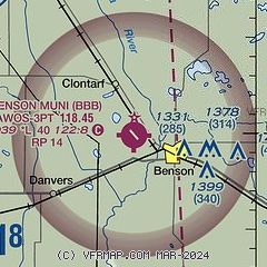
|
| Airport distance calculator |
|---|
|
|
| Sunrise and sunset |
|---|
|
Times for 26-Mar-2026
| | Local
(UTC-5) | | Zulu
(UTC) |
|---|
| Morning civil twilight | | 06:46 | | 11:46 |
| Sunrise | | 07:15 | | 12:15 |
| Sunset | | 19:41 | | 00:41 |
| Evening civil twilight | | 20:11 | | 01:11 |
|
| Current date and time |
|---|
| Zulu (UTC) | 26-Mar-2026 09:31:45 |
|---|
| Local (UTC-5) | 26-Mar-2026 04:31:45 |
|---|
|
| METAR |
|---|
| KBBB | 260915Z AUTO 02008KT 4SM -RA BR SCT049 BKN060 OVC075 09/09 A2980 RMK AO2
|
KAQP
16nm SW | 260915Z AUTO 03016KT 6SM -RA BR BKN085 OVC120 08/07 A2976 RMK AO2 PRESFR P0000 T00800071
|
KMOX
19nm NW | 260915Z AUTO 34018KT 5SM -RA BR FEW005 SCT029 BKN065 07/07 A2981 RMK AO2
|
|
| TAF |
|---|
KAXN
34nm N | 260539Z 2606/2706 36005KT P6SM BKN200 FM260700 01011KT 6SM -RA BR SCT025 OVC050 FM261100 01010KT 6SM -RA BR OVC026 FM261500 01014G24KT P6SM OVC015 FM262100 34014G21KT P6SM BKN025 FM270100 35010KT P6SM BKN030
|
|
| NOTAMs |
|---|
NOTAMs are issued by the DoD/FAA and will open in a separate window not controlled by AirNav.
|
|

