FAA INFORMATION EFFECTIVE 11 JUNE 2026
Location
| FAA Identifier: | BIH |
| Lat/Long: | 37-22-23.2000N 118-21-49.0000W
37-22.386667N 118-21.816667W
37.3731111,-118.3636111
(estimated) |
| Elevation: | 4124.3 ft. / 1257.1 m (surveyed) |
| Variation: | 15E (1985) |
| From city: | 2 miles E of BISHOP, CA |
| Time zone: | UTC -7 (UTC -8 during Standard Time) |
| Zip code: | 93514 |
Airport Operations
| Airport use: | Open to the public |
| Activation date: | 04/1940 |
| Control tower: | no |
| ARTCC: | OAKLAND CENTER |
| FSS: | RIVERSIDE FLIGHT SERVICE STATION |
| NOTAMs facility: | BIH (NOTAM-D service available) |
| Attendance: | 0800-1700
CONDS NOT MNT BTN 1700-0800.
ADMIN OFC AT ARPT 760-872-2971. AFTER HRS EMERG: 760-937-4017. |
| Wind indicator: | lighted |
| Segmented circle: | yes |
| Lights: | ACTVT REIL RWY 12, 30, 17, & 35; PAPI RWY 08, 26, 12, 30, 17, & 35; MIRL RWY 08/26, 12/30, & 17/35 - CTAF. |
| Beacon: | white-green (lighted land airport)
Operates sunset to sunrise. |
| Fire and rescue: | ARFF index B |
Airport Communications
| CTAF/UNICOM: | 123.0 |
| WX ASOS: | 119.025 (760-227-6035) |
- COMMUNICATIONS PRVDD BY RIVERSIDE RADIO ON FREQ 122.6 (BISHOP RCO).
- APCH/DEP CTL SVC PRVDD BY OAKLAND ARTCC (ZOA) ON FREQS 125.75/284.65 (BISHOP RCAG).
Nearby radio navigation aids
| VOR radial/distance | | VOR name | | Freq | | Var |
|---|
| BIH at field | | BISHOP VOR/DME | | 113.35 | | 15E |
Airport Services
| Fuel available: | 100LL JET-A |
| Parking: | tiedowns |
| Airframe service: | NONE |
| Powerplant service: | NONE |
| Bulk oxygen: | NONE |
Runway Information
Runway 12/30
| Dimensions: | 7498 x 100 ft. / 2285 x 30 m
PVD SHOULDER 10' TO LGTS PLUS 15' TO EDGE. |
| Surface: | asphalt/porous friction courses, in excellent condition |
| Weight bearing capacity: | | Single wheel: | 120.0 | | Double wheel: | 235.0 | | Double tandem: | 400.0 |
|
| Runway edge lights: | medium intensity |
| RUNWAY 12 | | RUNWAY 30 |
| Latitude: | 37-22.808488N | | 37-21.927497N |
| Longitude: | 118-22.400257W | | 118-21.315235W |
| Elevation: | 4122.6 ft. | | 4100.0 ft. |
| Traffic pattern: | left | | left |
| Runway heading: | 120 magnetic, 135 true | | 300 magnetic, 315 true |
| Declared distances: | TORA:7498 TODA:7498 ASDA:7098 LDA:7098 | | TORA:7498 TODA:7498 ASDA:6743 LDA:6743 |
| Markings: | nonprecision, in good condition | | nonprecision, in good condition |
| Visual slope indicator: | 4-light PAPI on left (3.00 degrees glide path) | | 4-light PAPI on left (3.52 degrees glide path)
PAPI UNUSBL BYD 4 NM. |
| Runway end identifier lights: | yes | | yes |
| Touchdown point: | yes, no lights | | yes, no lights |
| Obstructions: | none | | 35 ft. pline, 1555 ft. from runway, 175 ft. left of centerline, 38:1 slope to clear |
Runway 17/35
| Dimensions: | 5600 x 100 ft. / 1707 x 30 m
PVD SHOULDER 10' TO LGTS PLUS 15' TO EDGE. |
| Surface: | asphalt/porous friction courses, in good condition |
| Weight bearing capacity: | | PCN 49 /F/B/W/T | | Single wheel: | 100.0 | | Double wheel: | 140.0 | | Double tandem: | 240.0 |
|
| Runway edge lights: | medium intensity |
| RUNWAY 17 | | RUNWAY 35 |
| Latitude: | 37-22.844040N | | 37-21.921517N |
| Longitude: | 118-21.698335W | | 118-21.708252W |
| Elevation: | 4112.5 ft. | | 4104.9 ft. |
| Traffic pattern: | left | | left |
| Runway heading: | 165 magnetic, 180 true | | 345 magnetic, 000 true |
| Markings: | nonprecision, in good condition | | nonprecision, in good condition |
| Visual slope indicator: | 4-light PAPI on left (3.50 degrees glide path)
PAPI UNUSBL BYD 5 NM. | | 4-light PAPI on left (3.00 degrees glide path)
PAPI UNUSBL BYD 5 NM. |
| Runway end identifier lights: | yes | | yes |
| Touchdown point: | yes, no lights | | yes, no lights |
| Instrument approach: | LDA/DME | | |
| Obstructions: | none | | 30 ft. trees, 1442 ft. from runway, 41:1 slope to clear |
Runway 8/26
| Dimensions: | 5567 x 100 ft. / 1697 x 30 m |
| Surface: | asphalt, in fair condition |
| Weight bearing capacity: | | PCN 25 /F/A/W/T | | Single wheel: | 40.0 | | Double wheel: | 56.0 | | Double tandem: | 98.0 |
|
| Runway edge lights: | medium intensity |
| RUNWAY 8 | | RUNWAY 26 |
| Latitude: | 37-22.418982N | | 37-22.411048N |
| Longitude: | 118-22.448120W | | 118-21.298907W |
| Elevation: | 4124.1 ft. | | 4100.3 ft. |
| Traffic pattern: | left | | left |
| Runway heading: | 075 magnetic, 090 true | | 255 magnetic, 270 true |
| Markings: | nonprecision, in good condition | | nonprecision, in good condition |
| Visual slope indicator: | 2-light PAPI on left (3.50 degrees glide path)
PAPI UNUSBL BYD 5 NM. | | 2-light PAPI on left (3.00 degrees glide path)
PAPI UNUSBL BYD 2 NM. |
| Runway end identifier lights: | no | | no |
| Touchdown point: | yes, no lights | | yes, no lights |
| Obstructions: | 47 ft. trees, 1350 ft. from runway, 130 ft. left of centerline, 24:1 slope to clear | | none
10' DEEP DITCH 100' FROM THR. |
Helipad H2
| Dimensions: | 100 x 100 ft. / 30 x 30 m |
| Surface: | asphalt, in fair condition |
| Latitude: | 37-22.286167N | | |
| Longitude: | 118-22.489333W | | |
| Elevation: | 4124.0 ft. | | |
| Traffic pattern: | left | | left |
Helipad H1
| Dimensions: | 40 x 40 ft. / 12 x 12 m |
| Surface: | asphalt, in fair condition |
| Latitude: | 37-22.355667N | | |
| Longitude: | 118-22.048667W | | |
| Elevation: | 4124.0 ft. | | |
| Traffic pattern: | left | | left |
Airport Ownership and Management from official FAA records
| Ownership: | Publicly-owned |
| Owner: | INYO COUNTY
168 N EDWARDS, PO DRAWER Q
INDEPENDENCE, CA 93526
Phone 760-878-0201
LEASED, CONSTRUCTED AND MAINTAINED BY INYO COUNTY. CITY OF LOS ANGELES IS UNDERLYING LAND OWNER - 300 MANDICH ST, BISHOP CA 93514 |
| Manager: | ASHLEY HELMS
703 AIRPORT ROAD
BISHOP, CA 93514
Phone (760) 872-2971
ASHLEY HELMS, DEPUTY PUBLIC WORKS DIRECTOR - AIRPORTS; AHELMS@INYOCOUNTY.US. |
Additional Remarks
| A39-12/30 | PCR VALUE: 590/F/B/X/T |
| - | MAIN RAMP IS RSTRD TO PART 121; OTRS USE TSNT RAMP BY FUEL FARM. |
| - | NO INTXN DEPS; HEL TFC APCH ARPT FM THE WEST BOUNDARY. |
| - | RAMP FEES FOR COMM ACFT; MAY BE OFFSET WITH FUEL PURCHASE. |
| - | OVNGT TIE-DOWN FEE; ONE NIGHT MAY BE OFFSET WITH MIN FUEL PURCHASE. |
| - | FUEL DISCOUNTS FOR VOLUME PURCHASES. |
| - | NO LOCAL TAXI SERVICE; DIAL-A-RIDE AVBL, BUT LTD ON SUN. |
| - | FOR CD IF UNA TO CTC ON FSS FREQ, CTC OAKLAND ARTCC AT 510-745-3380. |
Instrument Procedures
NOTE: All procedures below are presented as PDF files. If you need a reader for these files, you should download the free Adobe Reader.NOT FOR NAVIGATION. Please procure official charts for flight.
FAA instrument procedures published for use from 11 June 2026 at 0901Z to 09 July 2026 at 0900z.
IAPs - Instrument Approach Procedures |
|---|
| RNAV (RNP) RWY 30 | |
download (894KB) |
| RNAV (GPS) Y RWY 12 | |
download (1058KB) |
| RNAV (GPS) Z RWY 12 | |
download (1035KB) |
| LDA RWY 17 | |
download (918KB) |
| LDA RWY 17 | |
download (918KB) |
| NOTE: Special Alternate Minimums apply | |
download (50KB) |
| NOTE: Special Take-Off Minimums/Departure Procedures apply | |
download (236KB) |
Other nearby airports with instrument procedures:
KMMH - Mammoth Yosemite Airport (27 nm NW)
O32 - Reedley Municipal Airport (67 nm SW)
KHTH - Hawthorne Industrial Airport (71 nm N)
KTPH - Tonopah Airport (73 nm NE)
KFAT - Fresno Yosemite International Airport (74 nm SW)
|
|

Road maps at:
MapQuest
Bing
Google
| Aerial photo |
|---|
WARNING: Photo may not be current or correct
 Photo by Ken Babione
Taken in May 2009
Photo by Ken Babione
Taken in May 2009
Do you have a better or more recent aerial photo of Bishop Airport that you would like to share? If so, please send us your photo.
|
| Sectional chart |
|---|
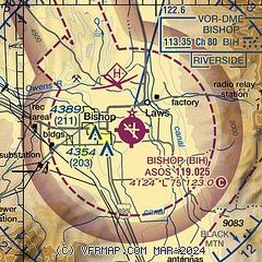
|
| Airport distance calculator |
|---|
|
|
| Sunrise and sunset |
|---|
|
Times for 22-Jun-2026
| | Local
(UTC-7) | | Zulu
(UTC) |
|---|
| Morning civil twilight | | 05:03 | | 12:03 |
| Sunrise | | 05:34 | | 12:34 |
| Sunset | | 20:17 | | 03:17 |
| Evening civil twilight | | 20:48 | | 03:48 |
|
| Current date and time |
|---|
| Zulu (UTC) | 23-Jun-2026 06:54:08 |
|---|
| Local (UTC-7) | 22-Jun-2026 23:54:08 |
|---|
|
| METAR |
|---|
| KBIH | 230556Z AUTO 14014KT 10SM CLR 27/M04 A3001 RMK AO2 PK WND 13026/0506 SLP104 T02671039 10361 20267 51022
|
|
| TAF |
|---|
| KBIH | 230520Z 2306/2406 15007KT P6SM SKC FM231000 VRB05KT P6SM SKC FM231900 16015G25KT P6SM SKC FM240500 15008KT P6SM FEW150
|
|
| NOTAMs |
|---|
NOTAMs are issued by the DoD/FAA and will open in a separate window not controlled by AirNav.
|
|

