FAA INFORMATION EFFECTIVE 30 OCTOBER 2025
Location
| FAA Identifier: | D90 |
| Lat/Long: | 44-55-25.1783N 085-04-03.5345W
44-55.419638N 085-04.058908W
44.9236606,-85.0676485
(estimated) |
| Elevation: | 1133 ft. / 345.3 m (surveyed) |
| Variation: | 05W (1985) |
| From city: | 2 miles N of MANCELONA, MI |
| Time zone: | UTC -5 (UTC -4 during Daylight Saving Time) |
| Zip code: | 49659 |
Airport Operations
| Airport use: | Open to the public |
| Activation date: | 08/1948 |
| Control tower: | no |
| ARTCC: | MINNEAPOLIS CENTER |
| FSS: | LANSING FLIGHT SERVICE STATION |
| NOTAMs facility: | LAN (NOTAM-D service available) |
| Attendance: | UNATNDD |
| Wind indicator: | yes |
| Segmented circle: | yes |
Airport Communications
| CTAF: | 122.9 |
| WX AWOS-3P at ACB (7 nm NW): | 119.275 (231-533-8941) |
| WX AWOS-3PT at BFA (16 nm NE): | 118.675 (231-330-8677) |
| WX ASOS at GLR (16 nm E): | 118.375 (989-732-1571) |
Nearby radio navigation aids
| VOR radial/distance | | VOR name | | Freq | | Var |
|---|
| CGGr321/(20.5) | | GRAYLING VOR | | 109.80 | | 06W |
| TVCr055/25.6 | | TRAVERSE CITY VOR/DME | | 114.60 | | 02W |
| NDB name | | Hdg/Dist | | Freq | | Var | | ID |
|---|
| BANGU | | 250/12.3 | | 375 | | 06W | | GL | --. .-.. |
| GRAYLING | | 322/14.6 | | 359 | | 06W | | GYG | --. -.-- --. |
Airport Services
Runway Information
Runway 18/36
| Dimensions: | 3400 x 140 ft. / 1036 x 43 m |
| Surface: | turf, in good condition |
| Runway edge markings: | 3 FT YELLOW CONES. |
| RUNWAY 18 | | RUNWAY 36 |
| Latitude: | 44-55.760000N | | 44-55.200333N |
| Longitude: | 085-04.136667W | | 085-04.143333W |
| Elevation: | 1129.0 ft. | | 1129.0 ft. |
| Traffic pattern: | left | | left |
| Runway heading: | 185 magnetic, 180 true | | 005 magnetic, 360 true |
| Runway end identifier lights: | no | | no |
| Obstructions: | 62 ft. tree, 996 ft. from runway, 140 ft. right of centerline, 16:1 slope to clear | | none |
Runway 10/28
| Dimensions: | 2050 x 120 ft. / 625 x 37 m |
| Surface: | turf, in good condition |
| Runway edge markings: | RWY & DTHR MKD WITH 3 FT YELLOW CONES. |
| RUNWAY 10 | | RUNWAY 28 |
| Latitude: | 44-55.353333N | | 44-55.285167N |
| Longitude: | 085-04.156667W | | 085-03.692167W |
| Elevation: | 1121.0 ft. | | 1121.0 ft. |
| Traffic pattern: | left | | left |
| Runway heading: | 107 magnetic, 102 true | | 287 magnetic, 282 true |
| Displaced threshold: | 830 ft. | | 200 ft. |
| Runway end identifier lights: | no | | no |
| Obstructions: | 62 ft. trees, 175 ft. from runway, 98 ft. left and right of centerline, 2:1 slope to clear
APCH RATIO 0:1 TO DTHR OVR 20 FT TREES, 0 FT DIST, 125 FT R. | | 16 ft. road, 90 ft. from runway, 134 ft. left and right of centerline, 5:1 slope to clear
APCH RATIO 7:1 TO DTHR OVR 62 FT TREE, 450 FT DIST, 125 FT L. |
Airport Ownership and Management from official FAA records
| Ownership: | Publicly-owned |
| Owner: | MANCELONA TOWNSHIP
PO BOX 332
MANCELONA, MI 49659-0332
Phone 231-587-5171 |
| Manager: | SHAWN D FLEET
7507 CEDAR RIVER RD
MANCELONA, MI 49659
Phone 231-645-3208 |
Additional Remarks
| - | ARPT CLSD NOV-APR 15 & WHEN SNOW COVD EXC FOR SKI EQUIPPED ACFT; RWYS NOT PLWD. |
| - | FOR CD CTC MINNEAPOLIS ARTCC AT 651-463-5588. |
Instrument Procedures
There are no published instrument procedures at D90.
Some nearby airports with instrument procedures:
KACB - Antrim County Airport (7 nm NW)
KBFA - Boyne Mountain Airport (16 nm NE)
KGLR - Gaylord Regional Airport (16 nm E)
N98 - Boyne City Municipal Airport (17 nm N)
KGOV - Grayling Army Airfield (21 nm SE)
|
|

Road maps at:
MapQuest
Bing
Google
| Aerial photo |
|---|

|
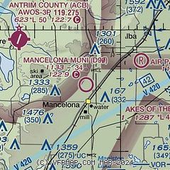
| Sectional chart |
|---|
|
| Airport distance calculator |
|---|
|
|
| Sunrise and sunset |
|---|
|
Times for 23-Nov-2025
| | Local
(UTC-5) | | Zulu
(UTC) |
|---|
| Morning civil twilight | | 07:17 | | 12:17 |
| Sunrise | | 07:49 | | 12:49 |
| Sunset | | 17:04 | | 22:04 |
| Evening civil twilight | | 17:37 | | 22:37 |
|
| Current date and time |
|---|
| Zulu (UTC) | 23-Nov-2025 11:54:53 |
|---|
| Local (UTC-5) | 23-Nov-2025 06:54:53 |
|---|
|
| METAR |
|---|
KACB
7nm NW | 231135Z AUTO 29007KT 260V340 10SM SCT028 BKN045 BKN055 07/00 A2990 RMK AO2 T00710002
|
KBFA
16nm NE | 231115Z AUTO 29009G21KT 250V330 10SM BKN027 OVC035 07/02 A2986 RMK AO2
|
KGLR
17nm E | 231122Z AUTO 29012G22KT 10SM FEW021 BKN030 OVC060 05/01 A2984 RMK AO2 T00500011
|
|
| TAF |
|---|
KTVC
24nm SW | 230521Z 2306/2406 24010KT P6SM BKN050 FM231400 28010G25KT P6SM BKN035 FM232200 29008KT P6SM SCT180
|
|
| NOTAMs |
|---|
NOTAMs are issued by the DoD/FAA and will open in a separate window not controlled by AirNav.
|
|

