FAA INFORMATION EFFECTIVE 11 JUNE 2026
Location
| FAA Identifier: | DLN |
| Lat/Long: | 45-15-19.3000N 112-33-09.0000W
45-15.321667N 112-33.150000W
45.2553611,-112.5525000
(estimated) |
| Elevation: | 5244.7 ft. / 1598.6 m (surveyed) |
| Variation: | 13E (2010) |
| From city: | 4 miles NE of DILLON, MT |
| Time zone: | UTC -6 (UTC -7 during Standard Time) |
| Zip code: | 59725 |
Airport Operations
| Airport use: | Open to the public |
| Activation date: | 05/1941 |
| Control tower: | no |
| ARTCC: | SALT LAKE CITY CENTER |
| FSS: | GREAT FALLS FLIGHT SERVICE STATION |
| NOTAMs facility: | DLN (NOTAM-D service available) |
| Attendance: | 0800-1700
AFT HR - AMGR OR 406-250-5280. |
| Wind indicator: | lighted |
| Segmented circle: | yes |
| Lights: | ACTVT PAPI RWY 17, 22, & 35; MIRL RWY 04/22 & 17/35 - CTAF. |
| Beacon: | white-green (lighted land airport)
Operates sunset to sunrise. |
| Landing fee: | yes |
Airport Communications
| CTAF/UNICOM: | 122.8 |
| WX ASOS: | 135.225 (406-683-5470) |
| WX AWOS-3PT at RVF (20 nm NE): | 119.025 (406-684-5285) |
- APCH/DEP CTL SVC PRVDD BY SALT LAKE ARTCC (ZLC) ON FREQS 132.4/338.3 (BOZEMAN RCAG).
Nearby radio navigation aids
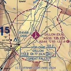
| VOR radial/distance | | VOR name | | Freq | | Var |
|---|
| DLN at field | | DILLON VOR/DME | | 113.00 | | 18E |
| HIAr186/39.8 | | WHITEHALL VOR/DME | | 113.70 | | 18E |
Airport Services
| Fuel available: | 100LL JET-A JET-A+ |
| Parking: | hangars and tiedowns |
| Airframe service: | NONE |
| Powerplant service: | NONE |
Runway Information
Runway 17/35
| Dimensions: | 6501 x 75 ft. / 1982 x 23 m |
| Surface: | asphalt/grooved, in excellent condition |
| Weight bearing capacity: | | Single wheel: | 58.0 | | Double wheel: | 106.0 | | Double tandem: | 129.0 |
|
| Runway edge lights: | medium intensity |
| Runway edge markings: | 1000 FT DSTC MKRS. |
| RUNWAY 17 | | RUNWAY 35 |
| Latitude: | 45-15.967927N | | 45-14.898915N |
| Longitude: | 112-33.149667W | | 112-33.112520W |
| Elevation: | 5156.7 ft. | | 5244.7 ft. |
| Traffic pattern: | left | | left |
| Runway heading: | 166 magnetic, 179 true | | 346 magnetic, 359 true |
| Markings: | nonprecision, in good condition | | nonprecision, in good condition |
| Visual slope indicator: | 2-light PAPI on left (3.00 degrees glide path) | | 2-light PAPI on left (3.00 degrees glide path)
PAPI UNUSBL BYD 5.0 NM. |
| Touchdown point: | yes, no lights | | yes, no lights |
Runway 4/22
| Dimensions: | 3600 x 60 ft. / 1097 x 18 m |
| Surface: | asphalt, in good condition |
| Weight bearing capacity: | | PCN 5 /F/D/Y/U | | Single wheel: | 12.5 |
|
| Runway edge lights: | medium intensity |
| RUNWAY 4 | | RUNWAY 22 |
| Latitude: | 45-14.929803N | | 45-15.309382N |
| Longitude: | 112-33.506995W | | 112-32.863380W |
| Elevation: | 5221.5 ft. | | 5226.9 ft. |
| Traffic pattern: | left | | left |
| Runway heading: | 037 magnetic, 050 true | | 217 magnetic, 230 true |
| Markings: | basic, in good condition | | basic, in good condition |
| Visual slope indicator: | | | 2-light PAPI on left (3.00 degrees glide path) |
| Touchdown point: | yes, no lights | | yes, no lights |
| Obstructions: | 5 ft. road, 254 ft. from runway, 130 ft. right of centerline, 10:1 slope to clear | | 16 ft. road, 450 ft. from runway, 250 ft. left of centerline, 15:1 slope to clear |
Airport Ownership and Management from official FAA records
| Ownership: | Publicly-owned |
| Owner: | BEAVERHEAD COUNTY
2 S. PACIFIC ST
DILLON, MT 59725-2799
Phone 406-683-5242 |
| Manager: | JOSIAH JONES
2400 AIRPORT ROAD
DILLON, MT 59725
Phone 406-660-1873 |
Additional Remarks
| A39-17/35 | PCR VALUE: 328/F/D/X/T |
| A30A-04 | DEP NA. |
| - | FOR CD IF UNA TO CTC ON FSS FREQ, CTC SALT LAKE ARTCC AT 801-320-2568. |
| - | RWY VIS BLOCKED BY HNGRS & BLDGS; CFM OTR ACFT & OPS BFR TKOF. |
Instrument Procedures
NOTE: All procedures below are presented as PDF files. If you need a reader for these files, you should download the free Adobe Reader.NOT FOR NAVIGATION. Please procure official charts for flight.
FAA instrument procedures published for use from 11 June 2026 at 0901Z to 09 July 2026 at 0900z.
IAPs - Instrument Approach Procedures |
|---|
| RNAV (GPS) RWY 17 | |
download (365KB) |
| RNAV (GPS) RWY 35 | |
download (350KB) |
| VOR/DME-B | |
download (345KB) |
| VOR-A | |
download (335KB) |
| NOTE: Special Alternate Minimums apply | |
download (68KB) |
| NOTE: Special Take-Off Minimums/Departure Procedures apply | |
download (620KB) |
Other nearby airports with instrument procedures:
KRVF - Ruby Valley Field Airport (20 nm NE)
KEKS - Ennis - Big Sky Airport (38 nm E)
KBTM - Bert Mooney Airport (42 nm N)
3U3 - Bowman Field Airport (55 nm N)
KSMN - Lemhi County Airport (57 nm W)
|
|

Road maps at:
MapQuest
Bing
Google
| Aerial photo |
|---|
WARNING: Photo may not be current or correct
 Photo by Guy Edwards
Photo taken 22-Oct-2010
looking north.
Photo by Guy Edwards
Photo taken 22-Oct-2010
looking north.
Do you have a better or more recent aerial photo of Dillon Airport that you would like to share? If so, please send us your photo.
|
| Sectional chart |
|---|
|
| Airport distance calculator |
|---|
|
|
| Sunrise and sunset |
|---|
|
Times for 15-Jun-2026
| | Local
(UTC-6) | | Zulu
(UTC) |
|---|
| Morning civil twilight | | 05:05 | | 11:05 |
| Sunrise | | 05:43 | | 11:43 |
| Sunset | | 21:19 | | 03:19 |
| Evening civil twilight | | 21:56 | | 03:56 |
|
| Current date and time |
|---|
| Zulu (UTC) | 15-Jun-2026 10:24:41 |
|---|
| Local (UTC-6) | 15-Jun-2026 04:24:41 |
|---|
|
| METAR |
|---|
| KDLN | 150953Z AUTO 20007KT 10SM CLR 06/M02 A3027 RMK AO2 SLP220 T00561017
|
KRVF
20nm NE | 150955Z AUTO 00000KT 10SM CLR 05/M02 A3028 RMK AO2
|
|
| TAF |
|---|
KEKS
38nm E | 150525Z 1506/1606 15006KT P6SM SKC FM152200 VRB06KT P6SM BKN250
|
KBTM
43nm N | 150533Z 1506/1606 15004KT P6SM SKC FM151800 31007G10KT P6SM SKC FM152200 32010G15KT P6SM SCT200 FM160300 31005KT P6SM SCT200
|
|
| NOTAMs |
|---|
NOTAMs are issued by the DoD/FAA and will open in a separate window not controlled by AirNav.
|
|

