FAA INFORMATION EFFECTIVE 11 JUNE 2026
Location
| FAA Identifier: | DUH |
| Lat/Long: | 41-44-09.1500N 083-39-20.7500W
41-44.152500N 083-39.345833W
41.7358750,-83.6557639
(estimated) |
| Elevation: | 671 ft. / 204.5 m (surveyed) |
| Variation: | 07W (2020) |
| From city: | 2 miles SW of LAMBERTVILLE, MI |
| Time zone: | UTC -4 (UTC -5 during Standard Time) |
| Zip code: | 49267 |
Airport Operations
| Airport use: | Open to the public |
| Activation date: | 07/1955 |
| Control tower: | no |
| ARTCC: | CLEVELAND CENTER |
| FSS: | LANSING FLIGHT SERVICE STATION |
| NOTAMs facility: | DUH (NOTAM-D service available) |
| Attendance: | 0800-1700 |
| Wind indicator: | lighted |
| Segmented circle: | yes |
| Lights: | ACTVT NSTD MIRL RWY 09/27 - CTAF. |
| Beacon: | white-green (lighted land airport)
Operates sunset to sunrise. |
Airport Communications
| CTAF/UNICOM: | 122.7 |
| WX AWOS-3P: | 119.175 (734-856-1563) |
| TOLEDO APPROACH: | 126.1 [0530-0000] |
| TOLEDO DEPARTURE: | 126.1 [0530-0000] |
| WX ASOS at TOL (11 nm SW): | PHONE 419-210-1094 |
| WX ASOS at TDZ (13 nm SE): | 121.575 (419-838-5034) |
| WX AWOS-3P at TTF (16 nm NE): | 119.075 (734-384-0259) |
Nearby radio navigation aids
| VOR radial/distance | | VOR name | | Freq | | Var |
|---|
| CRLr208/20.7 | | CARLETON VOR/DME | | 115.70 | | 03W |
| DXOr210/31.4 | | DETROIT VOR/DME | | 113.40 | | 06W |
| NDB name | | Hdg/Dist | | Freq | | Var | | ID |
|---|
| ADRIAN | | 119/20.5 | | 278 | | 06W | | ADG | .- -.. --. |
Airport Services
| Fuel available: | 100LL |
| Parking: | hangars and tiedowns |
| Airframe service: | MAJOR |
| Powerplant service: | MAJOR |
| Bottled oxygen: | NONE |
| Bulk oxygen: | NONE |
Runway Information
Runway 9/27
| Dimensions: | 4807 x 50 ft. / 1465 x 15 m |
| Surface: | asphalt, in good condition |
| Runway edge lights: | non-standard
NSTD MIRL DUE TO LCTN 15 FT FM RWY EDGE. |
| Runway edge markings: | FADED. |
| RUNWAY 9 | | RUNWAY 27 |
| Latitude: | 41-44.130167N | | 41-44.173000N |
| Longitude: | 083-39.874167W | | 083-38.819000W |
| Elevation: | 665.3 ft. | | 667.1 ft. |
| Traffic pattern: | left | | left |
| Runway heading: | 094 magnetic, 087 true | | 274 magnetic, 267 true |
| Displaced threshold: | 1274 ft. | | 992 ft. |
| Markings: | basic, in poor condition | | basic, in poor condition |
| Runway end identifier lights: | no | | no |
| Touchdown point: | yes, no lights | | yes, no lights |
| Obstructions: | 14 ft. tree, 200 ft. from runway, 98 ft. left of centerline
CTLG OBSTN EXCEEDS A 45 DEG SLP. APCH RATIO 20:1 TO DTHR. | | 84 ft. tree, 536 ft. from runway, 157 ft. right of centerline, 4:1 slope to clear
APCH RATIO 18:1 TO DTHR OVR +79 FT TREE, 1407 FT DIST, 40 FT L. |
Airport Ownership and Management from official FAA records
| Ownership: | Privately-owned |
| Owner: | SUBURBAN HOLDINGS INC
4383 SECTION RD
OTTAWA LAKE, MI 49267-9620
Phone 734-856-6103 |
| Manager: | LUKAS RODRIGUEZ
4383 SECTION RD
OTTAWA LAKE, MI 49267-9620
Phone 734-856-6103 |
Additional Remarks
| - | 4 FT FENCE, 110 FT NORTH OF RWY; +8 FT SEASONAL CROPS, 50 FT SOUTH OF RWY IN PRI SFC. |
| - | DEER & LRG BIRDS ON & INVOF ARPT. |
| - | FOR CD CTC TOLEDO APCH AT 419-865-1495. |
Instrument Procedures
NOTE: All procedures below are presented as PDF files. If you need a reader for these files, you should download the free Adobe Reader.NOT FOR NAVIGATION. Please procure official charts for flight.
FAA instrument procedures published for use from 11 June 2026 at 0901Z to 09 July 2026 at 0900z.
IAPs - Instrument Approach Procedures |
|---|
| RNAV (GPS)-A | |
download (129KB) |
| NOTE: Special Take-Off Minimums/Departure Procedures apply | |
download (376KB) |
Other nearby airports with instrument procedures:
KTOL - Eugene F Kranz Toledo Express Airport (11 nm SW)
KTDZ - Toledo Executive Airport (13 nm SE)
KTTF - Custer Airport (16 nm NE)
KADG - Lenawee County Airport (20 nm NW)
1G0 - Wood County Regional Airport (21 nm S)
|
|

Road maps at:
MapQuest
Bing
Google
| Aerial photo |
|---|
WARNING: Photo may not be current or correct
 Photo taken 29-Oct-2005
Final approach Runway 27
Photo taken 29-Oct-2005
Final approach Runway 27
Do you have a better or more recent aerial photo of Toledo Suburban Airport that you would like to share? If so, please send us your photo.
|
| Sectional chart |
|---|
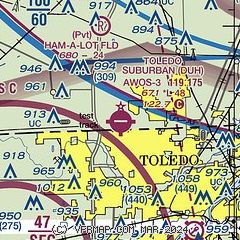
|
| Airport distance calculator |
|---|
|
|
| Sunrise and sunset |
|---|
|
Times for 18-Jun-2026
| | Local
(UTC-4) | | Zulu
(UTC) |
|---|
| Morning civil twilight | | 05:26 | | 09:26 |
| Sunrise | | 06:00 | | 10:00 |
| Sunset | | 21:11 | | 01:11 |
| Evening civil twilight | | 21:45 | | 01:45 |
|
| Current date and time |
|---|
| Zulu (UTC) | 18-Jun-2026 18:53:55 |
|---|
| Local (UTC-4) | 18-Jun-2026 14:53:55 |
|---|
|
| METAR |
|---|
| KDUH | 181835Z AUTO 28011G18KT 250V310 10SM BKN038 OVC048 20/12 A2968 RMK AO2 PK WND 27027/36
|
KTOL
11nm SW | 181752Z 28016G26KT 10SM FEW035 BKN043 22/12 A2968 RMK AO2 PK WND 25033/1739 SLP046 T02170117 10222 20206 53042 $
|
KTDZ
13nm SE | 181753Z AUTO 27022G29KT 10SM BKN042 BKN055 22/13 A2967 RMK AO2 PK WND 25032/1720 SLP043 T02220128 10233 20211 53037
|
KTTF
16nm NE | 180555Z AUTO 22012G16KT 10SM BKN021 OVC029 21/19 A2936 RMK AO2 10207 20164
|
|
| TAF |
|---|
KTOL
11nm SW | 181742Z 1818/1918 28020G30KT P6SM BKN050 FM182100 28015G22KT P6SM SCT050 FM190000 27007KT P6SM SKC FM190300 VRB04KT P6SM FEW090 FM191300 28012KT P6SM SCT050 SCT090
|
|
| NOTAMs |
|---|
NOTAMs are issued by the DoD/FAA and will open in a separate window not controlled by AirNav.
|
|

