FAA INFORMATION EFFECTIVE 27 NOVEMBER 2025
Location
| FAA Identifier: | EHO |
| Lat/Long: | 35-15-20.6970N 081-36-02.7520W
35-15.344950N 081-36.045867W
35.2557492,-81.6007644
(estimated) |
| Elevation: | 846.6 ft. / 258.0 m (surveyed) |
| Variation: | 06W (2000) |
| From city: | 3 miles SW of SHELBY, NC |
| Time zone: | UTC -5 (UTC -4 during Daylight Saving Time) |
| Zip code: | 28152 |
Airport Operations
| Airport use: | Open to the public |
| Activation date: | 08/1958 |
| Control tower: | no |
| ARTCC: | ATLANTA CENTER |
| FSS: | RALEIGH FLIGHT SERVICE STATION |
| NOTAMs facility: | EHO (NOTAM-D service available) |
| Attendance: | MON-FRI 0800-1700, ALL SUN 1300-1600, ALL SAT 1000-1500 |
| Wind indicator: | lighted |
| Segmented circle: | yes |
| Lights: | DUSK-2300. AFTER 2300 ACTVT MIRL RWY 05/23 - CTAF. PAPI RWY 05 & 23 OPER CONSLY. |
| Beacon: | white-green (lighted land airport)
Operates sunset to sunrise. |
Airport Communications
| CTAF/UNICOM: | 122.8 |
| WX AWOS-3: | 118.425 (704-487-0100) |
| CHARLOTTE APPROACH: | 120.05 |
| CHARLOTTE DEPARTURE: | 120.05 |
| JOOLS STAR: | 135.6 |
| RASLN STAR: | 126.15 |
| WX AWOS-3 at FQD (19 nm NW): | 118.275 (828-287-6498) |
Nearby radio navigation aids
| VOR radial/distance | | VOR name | | Freq | | Var |
|---|
| SPAr052/20.8 | | SPARTANBURG VORTAC | | 115.70 | | 02W |
| CLTr282/32.1 | | CHARLOTTE VOR/DME | | 115.00 | | 05W |
| SUGr107/33.9 | | SUGARLOAF MOUNTAIN VORTAC | | 112.20 | | 02W |
| NDB name | | Hdg/Dist | | Freq | | Var | | ID |
|---|
| FIRST RIVER | | at field | | 417 | | 06W | | SLP | ... .-.. .--. |
| STONIA | | 286/22.0 | | 260 | | 06W | | GHJ | --. .... .--- |
| FIDDLERS | | 180/27.5 | | 391 | | 07W | | FIQ | ..-. .. --.- |
| UNION COUNTY | | 009/34.4 | | 326 | | 06W | | UOT | ..- --- - |
| CHESTER | | 331/34.4 | | 220 | | 06W | | DCM | -.. -.-. -- |
Airport Services
| Fuel available: | 100LL JET-A1+
100LL:100LL FUEL 24 HR CREDIT CARD SVC AVBL. |
| Parking: | tiedowns |
| Airframe service: | MAJOR |
| Powerplant service: | MAJOR |
| Bottled oxygen: | NONE |
| Bulk oxygen: | NONE |
Runway Information
Runway 5/23
| Dimensions: | 5001 x 100 ft. / 1524 x 30 m |
| Surface: | asphalt, in good condition |
| Weight bearing capacity: | |
| Runway edge lights: | medium intensity |
| RUNWAY 5 | | RUNWAY 23 |
| Latitude: | 35-15.048003N | | 35-15.641882N |
| Longitude: | 081-36.394340W | | 081-35.697338W |
| Elevation: | 833.8 ft. | | 836.8 ft. |
| Traffic pattern: | left | | left |
| Runway heading: | 050 magnetic, 044 true | | 230 magnetic, 224 true |
| Markings: | nonprecision, in good condition | | nonprecision, in good condition |
| Visual slope indicator: | 2-light PAPI on left (3.00 degrees glide path) | | 2-light PAPI on left (3.00 degrees glide path) |
| Runway end identifier lights: | no | | no |
| Touchdown point: | yes, no lights | | yes, no lights |
| Obstructions: | 44 ft. trees, 955 ft. from runway, 307 ft. right of centerline, 17:1 slope to clear | | 40 ft. trees, 994 ft. from runway, 38 ft. left of centerline, 19:1 slope to clear |
Airport Ownership and Management from official FAA records
| Ownership: | Publicly-owned |
| Owner: | CITY OF SHELBY
830 COLLEGE AVE, HIGHWAY 150
SHELBY, NC 28152
Phone 704-487-1161 |
| Manager: | JACK POOLE
830 COLLEGE AVE, HIGHWAY 150
SHELBY, NC 28152
Phone 704-487-1161 |
Additional Remarks
| - | FOR SERVICE AFTER HOURS CALL 704 284-3321. |
| - | RY 23 HAS 35 FT DROP-OFF 600 FT FM THLD 0B. |
| - | RY 05 HAS 45 FT DROP-OFF 100 FT FM THLD 0B. |
| - | FOR CD CTC CHARLOTTE APCH AT 704-359-0241. |
| - | REFER TO CHARLOTTE SECTIONAL CHART FOR TOWERS OFF BOTH RWY ENDS. |
Instrument Procedures
NOTE: All procedures below are presented as PDF files. If you need a reader for these files, you should download the free Adobe Reader.NOT FOR NAVIGATION. Please procure official charts for flight.
FAA instrument procedures published for use from 27 November 2025 at 0901Z to 25 December 2025 at 0900Z.
STARs - Standard Terminal Arrivals |
|---|
| JOOLS ONE (RNAV) | |
download (273KB) |
| LIINN THREE | |
2 pages:
[1] [2] (280KB) |
| MAJIC FOUR | |
download (262KB) |
| RASLN THREE | |
download (177KB) |
IAPs - Instrument Approach Procedures |
|---|
| RNAV (GPS) RWY 05 | |
download (231KB) |
| RNAV (GPS) RWY 23 | |
download (219KB) |
| NDB RWY 23 | |
download (228KB) |
| NOTE: Special Alternate Minimums apply | |
download (25KB) |
| NOTE: Special Take-Off Minimums/Departure Procedures apply | |
download (141KB) |
Other nearby airports with instrument procedures:
KFQD - Rutherford County Airport/Marchman Field (19 nm NW)
KAKH - Gastonia Municipal Airport (22 nm E)
KIPJ - Lincolnton-Lincoln County Regional Airport (25 nm NE)
KSPA - Spartanburg Downtown Memorial Airport/Simpson Field (27 nm SW)
KHKY - Hickory Regional Airport (31 nm N)
|
|

Road maps at:
MapQuest
Bing
Google
| Aerial photo |
|---|
WARNING: Photo may not be current or correct
 Photo taken 21-Jun-2007
from 13,000 feet MSL
Photo taken 21-Jun-2007
from 13,000 feet MSL
Do you have a better or more recent aerial photo of Shelby-Cleveland County Regional Airport that you would like to share? If so, please send us your photo.
|
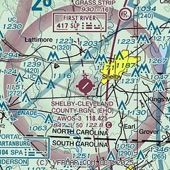
| Sectional chart |
|---|
|
| Airport distance calculator |
|---|
|
|
| Sunrise and sunset |
|---|
|
Times for 12-Dec-2025
| | Local
(UTC-5) | | Zulu
(UTC) |
|---|
| Morning civil twilight | | 06:58 | | 11:58 |
| Sunrise | | 07:27 | | 12:27 |
| Sunset | | 17:14 | | 22:14 |
| Evening civil twilight | | 17:42 | | 22:42 |
|
| Current date and time |
|---|
| Zulu (UTC) | 12-Dec-2025 21:50:25 |
|---|
| Local (UTC-5) | 12-Dec-2025 16:50:25 |
|---|
|
| METAR |
|---|
| KEHO | 122135Z AUTO 00000KT 10SM CLR 09/M03 A3007 RMK AO2 T00921029
|
KFQD
19nm NW | 122135Z AUTO 00000KT 10SM CLR 08/M03 A3008 RMK AO2
|
|
| TAF |
|---|
KHKY
31nm N | 121722Z 1218/1318 VRB03KT P6SM SCT100 SCT250 FM130200 VRB02KT P6SM FEW250 FM131600 24004KT P6SM SKC
|
KCLT
32nm E | 121955Z 1220/1324 15006KT P6SM FEW100 FEW250 FM122300 08004KT P6SM SKC FM130800 VRB02KT P6SM FEW250 FM131800 22006KT P6SM FEW250
|
KGSP
37nm SW | 121722Z 1218/1318 23006KT P6SM FEW250 FM130200 VRB02KT P6SM FEW250 FM131700 24005KT P6SM SKC
|
|
| NOTAMs |
|---|
NOTAMs are issued by the DoD/FAA and will open in a separate window not controlled by AirNav.
|
|


