FAA INFORMATION EFFECTIVE 15 MAY 2025
Location
| FAA Identifier: | F21 |
| Lat/Long: | 34-44-22.5220N 100-31-46.9230W
34-44.375367N 100-31.782050W
34.7395894,-100.5297008
(estimated) |
| Elevation: | 2102 ft. / 641 m (estimated) |
| Variation: | 08E (1985) |
| From city: | 1 mile NE of MEMPHIS, TX |
| Time zone: | UTC -5 (UTC -6 during Standard Time) |
| Zip code: | 79245 |
Airport Operations
| Airport use: | Open to the public |
| Activation date: | 12/1946 |
| Control tower: | no |
| ARTCC: | ALBUQUERQUE CENTER |
| FSS: | FORT WORTH FLIGHT SERVICE STATION |
| NOTAMs facility: | FTW (NOTAM-D service available) |
| Attendance: | UNATNDD |
| Wind indicator: | lighted |
| Segmented circle: | yes |
| Lights: | DUSK-DAWN. ACTVT MIRL RY 17/35 - CTAF. |
| Beacon: | white-green (lighted land airport)
Operates sunset to sunrise. |
Airport Communications
Nearby radio navigation aids
| VOR radial/distance | | VOR name | | Freq | | Var |
|---|
| CDSr322/25.2 | | CHILDRESS VORTAC | | 117.00 | | 10E |
Airport Services
| Parking: | tiedowns |
| Airframe service: | NONE |
| Powerplant service: | NONE |
| Bottled oxygen: | NONE |
| Bulk oxygen: | NONE |
Runway Information
Runway 17/35
| Dimensions: | 4670 x 75 ft. / 1423 x 23 m |
| Surface: | asphalt, in fair condition |
| Weight bearing capacity: | |
| Runway edge lights: | medium intensity |
| RUNWAY 17 | | RUNWAY 35 |
| Latitude: | 34-44.893000N | | 34-44.123167N |
| Longitude: | 100-31.849833W | | 100-31.859500W |
| Elevation: | 2102.0 ft. | | 2070.0 ft. |
| Traffic pattern: | left | | left |
| Runway heading: | 173 magnetic, 181 true | | 353 magnetic, 001 true |
| Markings: | nonprecision, in good condition | | nonprecision, in good condition |
| Obstructions: | none | | 25 ft. trees, 800 ft. from runway, 24:1 slope to clear |
Runway 8/26
| Dimensions: | 2750 x 70 ft. / 838 x 21 m |
| Surface: | turf, in good condition |
| Runway edge markings: | & RWY 26 THRS MRKD WITH RED & WHITE METAL MARKERS. |
| RUNWAY 8 | | RUNWAY 26 |
| Latitude: | 34-44.150000N | | 34-44.150000N |
| Longitude: | 100-31.933333W | | 100-31.384167W |
| Traffic pattern: | left | | left |
| Runway heading: | 082 magnetic, 090 true | | 262 magnetic, 270 true |
| Obstructions: | 8 ft. road, 100 ft. from runway, 12:1 slope to clear | | 22 ft. trees, 70 ft. from runway, 60 ft. right of centerline, 3:1 slope to clear |
Airport Ownership and Management from official FAA records
| Ownership: | Publicly-owned |
| Owner: | CITY OF MEMPHIS
721 ROBERTSON ST
MEMPHIS, TX 79245
Phone 806-259-3001 |
| Manager: | DAVID MORRIS
721 ROBERTSON ST
MEMPHIS, TX 79245
Phone 806-259-3001
DIRECTOR OF PUBLIC WORKS. |
Additional Remarks
| - | FOR CD CTC ALBUQUERQUE ARTCC AT 505-856-4861. |
| - | ACFT LDG RWY 08, PLAN TOUCHDOWN BYD PAVED RWY. |
| - | RWY 08/26 TRSN ACRS PAVED RWY 17/35 ROUGH. |
Instrument Procedures
There are no published instrument procedures at F21.
Some nearby airports with instrument procedures:
KCDS - Childress Municipal Airport (22 nm SE)
O35 - Hollis Municipal Airport (31 nm E)
3F6 - Dan E Richards Municipal Airport (44 nm S)
T59 - Wheeler Municipal Airport (46 nm N)
2K4 - Scott Field Airport (50 nm E)
|
|

Road maps at:
MapQuest
Bing
Google
| Aerial photo |
|---|
WARNING: Photo may not be current or correct
 Photo taken 18-Dec-2006
Do you have a better or more recent aerial photo of Memphis Municipal Airport that you would like to share? If so, please send us your photo.
|
| Sectional chart |
|---|
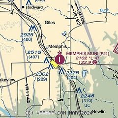
|
| Airport distance calculator |
|---|
|
|
| Sunrise and sunset |
|---|
|
Times for 06-Jun-2025
| | Local
(UTC-5) | | Zulu
(UTC) |
|---|
| Morning civil twilight | | 06:00 | | 11:00 |
| Sunrise | | 06:30 | | 11:30 |
| Sunset | | 20:52 | | 01:52 |
| Evening civil twilight | | 21:21 | | 02:21 |
|
| Current date and time |
|---|
| Zulu (UTC) | 07-Jun-2025 01:21:33 |
|---|
| Local (UTC-5) | 06-Jun-2025 20:21:33 |
|---|
|
| METAR |
|---|
KCDS
22nm SE | 070053Z AUTO 16006KT 10SM TS CLR 28/22 A2985 RMK AO2 LTG DSNT SW-NW TSB50 SLP084 T02830217
|
|
| TAF |
|---|
KCDS
22nm SE | 061731Z 0618/0718 12008KT P6SM SCT040 PROB30 0703/0706 -TSRA BKN040CB FM070600 16008KT P6SM OVC100 FM071400 03008KT P6SM FEW050
|
|
| NOTAMs |
|---|
NOTAMs are issued by the DoD/FAA and will open in a separate window not controlled by AirNav.
|
|


