FAA INFORMATION EFFECTIVE 30 OCTOBER 2025
Location
| FAA Identifier: | H17 |
| Lat/Long: | 37-39-14.7000N 093-05-13.2000W
37-39.245000N 093-05.220000W
37.6540833,-93.0870000
(estimated) |
| Elevation: | 1154 ft. / 352 m (estimated) |
| Variation: | 04E (1985) |
| From city: | 1 mile N of BUFFALO, MO |
| Time zone: | UTC -6 (UTC -5 during Daylight Saving Time) |
| Zip code: | 65622 |
Airport Operations
| Airport use: | Open to the public |
| Activation date: | 12/1952 |
| Control tower: | no |
| ARTCC: | KANSAS CITY CENTER |
| FSS: | COLUMBIA FLIGHT SERVICE STATION |
| NOTAMs facility: | COU (NOTAM-D service available) |
| Attendance: | UNATNDD |
| Wind indicator: | lighted |
| Segmented circle: | yes |
| Lights: | ACTVT LIRL RY 04/22 & PERIMETER LGTS - CTAF. |
| Beacon: | white-green (lighted land airport)
Operates sunset to sunrise. |
Airport Communications
Nearby radio navigation aids
| VOR radial/distance | | VOR name | | Freq | | Var |
|---|
| SGFr029/21.4 | | SPRINGFIELD VORTAC | | 116.90 | | 04E |
| SHYr225/32.6 | | SUNSHINE VOR/DME | | 108.40 | | 00E |
| DGDr344/39.1 | | DOGWOOD VORTAC | | 109.40 | | 01E |
Airport Services
| Fuel available: | 100LL |
| Parking: | tiedowns |
| Bottled oxygen: | NONE |
| Bulk oxygen: | NONE |
Runway Information
Runway 4/22
| Dimensions: | 3220 x 50 ft. / 981 x 15 m
WIDTH VARIANCE 50-52 FT. |
| Surface: | asphalt, in good condition |
| Runway edge lights: | low intensity |
| RUNWAY 4 | | RUNWAY 22 |
| Latitude: | 37-39.025667N | | 37-39.463500N |
| Longitude: | 093-05.408000W | | 093-05.031667W |
| Elevation: | 1152.0 ft. | | 1148.0 ft. |
| Traffic pattern: | left | | left |
| Displaced threshold: | 272 ft. | | no |
| Markings: | basic, in good condition | | basic, in good condition |
| Obstructions: | 47 ft. tree, 310 ft. from runway, 75 ft. right of centerline, 2:1 slope to clear
RWY 04 +1-19 FT TREES, FENCES, 35-200 FT FM RWY END, L/R. | | 49 ft. tree, 270 ft. from runway, 115 ft. left of centerline, 1:1 slope to clear
RWY 22 +1-35 FT FENCES, TREES & BRUSH 0-200 FT FM RY END, L/R. |
Helipad H1
| Dimensions: | 40 x 40 ft. / 12 x 12 m |
| Surface: | asphalt, in good condition |
| Runway edge lights: | PERI
5 LANDING DIRECTION LIGHTS EXTENDING NORTHEAST. |
| Latitude: | 37-39.051167N | | |
| Longitude: | 093-05.343167W | | |
| Elevation: | 1148.0 ft. | | |
| Traffic pattern: | left | | left |
| Markings: | , in good condition | | |
Airport Ownership and Management from official FAA records
| Ownership: | Publicly-owned |
| Owner: | BUFFALO, CITY OF
115 SOUTH MAPLE STREET, P.O. BOX 410
BUFFALO, MO 65622
Phone 417-345-2701 |
| Manager: | JEFFERY LILLEY
18 CH GROVE RD
BUFFALO, MO 65622
Phone 417-839-9306
ALT. PHONE 417-345-1120. |
Additional Remarks
| - | ULTRALIGHT ACFT ON & INVOF ARPT. |
| - | WILDLIFE ON AND INVOF ARPT. |
| - | INSUF RWY SAFETY AREA LEN BYD EACH RWY END; FENCES, BRUSH, TREES. |
| - | APCH SLP 8 TO 1 TO HELIPAD FROM NORTHEAST; ARPT BCN 260 FT SOUTH OF HELIPAD, 5 TO 1 APCH SLP. |
| - | FOR CD CTC SPRINGFIELD APCH AT 417-868-5620/5619. |
Instrument Procedures
There are no published instrument procedures at H17.
Some nearby airports with instrument procedures:
M17 - Bolivar Municipal Airport (13 nm W)
KLBO - Floyd W Jones Lebanon Airport (21 nm E)
KOZS - Camdenton Memorial-Lake Regional Airport (27 nm NE)
3DW - Downtown Airport (27 nm S)
KSGF - Springfield-Branson National Airport (28 nm SW)
|
|

Road maps at:
MapQuest
Bing
Google
| Aerial photo |
|---|
WARNING: Photo may not be current or correct

Do you have a better or more recent aerial photo of Buffalo Municipal Airport that you would like to share? If so, please send us your photo.
|
| Sectional chart |
|---|
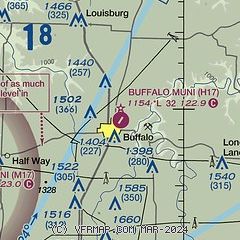
|
| Airport distance calculator |
|---|
|
|
| Sunrise and sunset |
|---|
|
Times for 13-Nov-2025
| | Local
(UTC-6) | | Zulu
(UTC) |
|---|
| Morning civil twilight | | 06:23 | | 12:23 |
| Sunrise | | 06:51 | | 12:51 |
| Sunset | | 17:02 | | 23:02 |
| Evening civil twilight | | 17:30 | | 23:30 |
|
| Current date and time |
|---|
| Zulu (UTC) | 13-Nov-2025 23:16:03 |
|---|
| Local (UTC-6) | 13-Nov-2025 17:16:03 |
|---|
|
| METAR |
|---|
KLBO
21nm E | 132255Z AUTO 16006KT 10SM CLR 18/06 A3010 RMK AO2
|
|
| TAF |
|---|
KSGF
29nm SW | 131736Z 1318/1418 16010KT P6SM BKN250 FM140700 18008KT P6SM FEW220 WS020/22035KT FM141200 16010KT P6SM SCT250
|
|
| NOTAMs |
|---|
NOTAMs are issued by the DoD/FAA and will open in a separate window not controlled by AirNav.
|
|

