FAA INFORMATION EFFECTIVE 21 MARCH 2024
Location
| FAA Identifier: | IPL |
| Lat/Long: | 32-50-03.2000N 115-34-43.5000W
32-50.053333N 115-34.725000W
32.8342222,-115.5787500
(estimated) |
| Elevation: | -53.6 ft. / -16.3 m (surveyed) |
| Variation: | 14E (1980) |
| From city: | 1 mile S of IMPERIAL, CA |
| Time zone: | UTC -7 (UTC -8 during Standard Time) |
| Zip code: | 92251 |
Airport Operations
| Airport use: | Open to the public |
| Activation date: | 04/1940 |
| Control tower: | no |
| ARTCC: | LOS ANGELES CENTER |
| FSS: | SAN DIEGO FLIGHT SERVICE STATION |
| NOTAMs facility: | IPL (NOTAM-D service available) |
| Attendance: | 0700-1630 |
| Wind indicator: | yes |
| Segmented circle: | yes |
| Lights: | ACTVT MIRL RWYS 08/26 & 14/32 - CTAF. |
| Beacon: | white-green (lighted land airport)
Operates sunset to sunrise. |
| Landing fee: | yes, OVERNIGHT TIE-DOWN FEE. |
| Fire and rescue: | ARFF index A |
| Airline operations: | RWY 8/26 NOT AVBL FOR SKED ACR OPNS WITH MORE THAN 9 PSGR SEATS OR UNSKED ACR AT LEAST 31 PSGR SEATS. |
Airport Communications
| CTAF/UNICOM: | 122.7 |
| WX ASOS: | 132.175 (760-355-2851) |
- APCH/DEP CTL SVC PRVDD BY YUMA CERAP ON 128.55/292.2 (EL CENTRO RCAG).
Nearby radio navigation aids
| VOR radial/distance | | VOR name | | Freq | | Var |
|---|
| IPLr311/6.2 | | IMPERIAL VORTAC | | 115.90 | | 14E |
Airport Services
| Fuel available: | 100LL JET-A |
| Parking: | tiedowns |
| Airframe service: | NONE |
| Powerplant service: | NONE |
| Bottled oxygen: | NONE |
| Bulk oxygen: | NONE |
Runway Information
Runway 14/32
| Dimensions: | 5308 x 100 ft. / 1618 x 30 m |
| Surface: | asphalt/porous friction courses, in good condition |
| Weight bearing capacity: | | PCN 26 /F/C/W/T | | Single wheel: | 60.0 | | Double wheel: | 80.0 | | Double tandem: | 102.0 | | Dual double tandem: | 130.0 |
|
| Runway edge lights: | medium intensity |
| RUNWAY 14 | | RUNWAY 32 |
| Latitude: | 32-50.550735N | | 32-49.773007N |
| Longitude: | 115-34.757513W | | 115-34.281872W |
| Elevation: | -55.1 ft. | | -53.9 ft. |
| Traffic pattern: | left | | right |
| Runway heading: | 139 magnetic, 153 true | | 319 magnetic, 333 true |
| Declared distances: | TORA:5304 TODA:5304 ASDA:5304 LDA:5304 | | TORA:5304 TODA:5304 ASDA:5304 LDA:5304 |
| Markings: | nonprecision, in good condition | | nonprecision, in good condition |
| Visual slope indicator: | 4-light PAPI on left (3.00 degrees glide path) | | 4-light PAPI on left (3.00 degrees glide path) |
| Runway end identifier lights: | no | | no |
| Touchdown point: | yes, no lights | | yes, no lights |
| Obstructions: | 9 ft. fence, lighted, 425 ft. from runway, 130 ft. left of centerline, 25:1 slope to clear | | 15 ft. road, 600 ft. from runway, 150 ft. right of centerline, 26:1 slope to clear |
Runway 8/26
| Dimensions: | 4501 x 75 ft. / 1372 x 23 m |
| Surface: | asphalt, in good condition |
| Weight bearing capacity: | | PCN 6 /F/D/W/T | | Single wheel: | 50.0 | | Double wheel: | 50.0 |
|
| Runway edge lights: | medium intensity |
| RUNWAY 8 | | RUNWAY 26 |
| Latitude: | 32-49.926267N | | 32-49.926657N |
| Longitude: | 115-35.407285W | | 115-34.528360W |
| Elevation: | -55.1 ft. | | -55.0 ft. |
| Traffic pattern: | left | | right |
| Runway heading: | 076 magnetic, 090 true | | 256 magnetic, 270 true |
| Declared distances: | TORA:4501 TODA:4501 ASDA:4501 LDA:4501 | | TORA:4501 TODA:4501 ASDA:4501 LDA:4501 |
| Markings: | basic, in good condition | | basic, in good condition |
| Visual slope indicator: | 4-light PAPI on left (3.00 degrees glide path) | | 4-light PAPI on left (3.00 degrees glide path) |
| Touchdown point: | yes, no lights | | yes, no lights |
| Obstructions: | 59 ft. pline, marked and lighted, 1600 ft. from runway, 23:1 slope to clear | | 32 ft. pole, 1575 ft. from runway, 250 ft. right of centerline, 42:1 slope to clear |
Airport Ownership and Management from official FAA records
| Ownership: | Publicly-owned |
| Owner: | IMPERIAL COUNTY
1099 AIRPORT ROAD
IMPERIAL, CA 92251
Phone 442-265-1001 |
| Manager: | JENELL GUERRERO
1099 AIRPORT ROAD
IMPERIAL, CA 92251
Phone 442-265-3220 |
Airport Operational Statistics
| Aircraft based on the field: | | 32 | | Single engine airplanes: | | 28 | | Multi engine airplanes: | | 2 | | Helicopters: | | 2 |
| |  | |
| Aircraft operations: avg 123/week * | | 57% | military | | 17% | local general aviation | | 13% | commercial | | 8% | transient general aviation | | 5% | air taxi | | * for 12-month period ending 31 December 2022 | |
Additional Remarks
| - | PPR FOR NON-SKEDD AIR CARRIER ARFF SER, CONTACT AMER 442-264-3220. |
| - | TWY C3 CLSD BTN RWY 14/32 AND TWY C5. |
| - | NOISE ABATEMENT: NOISE SENSITIVE AREA NE EDGE OF AP: SCHOOLS AND RESIDENTIAL. CONDS PMTG, HEL ARRS SHOULD BE TO RWY 32, TOUCHDOWN MIDFIELD (BTN TWY A4 AND A3). HEL DEPARTURES SHOULD BE FM RWY 14 MIDFIELD. WHEN CONDS REQ RWY 32 DEPARTURE, MNTN RWY CNTRLN FOR 1.5 NM BEFORE INITIATING TURN. FOR HEL TRNG PATS/AUTOROTATIONS USE RWY 08/26, MAX OF 3 CIRCUITS. BTN SS-SR AVOID CONS PAT CIRCUITS. |
| - | FOR CD CTC YUMA CERAP AT 928-269-9569. |
| - | AVOID NAF EL CENTRO TFC; ACFT DEPG RWY 26 MAKE IMT RIGHT TURN - STAY BELOW 1000 FT; CTC NAF TWR 119.1 FOR ADZY. |
| - | FRQ HIGH-SPD MIL JET TFC TRANSITS IMPERIAL COUNTY TFC AREA WB DESCENDING VFR TO NAF EL CENRTO. AVOID 2500 FT TO 3500 FT MSL NEAR IMPERIAL COUNTY. CTC NAF TWR 119.1 FOR NAVY TFC ADZY. |
| - | RADIO ANT +70 FT LCTD ON CTL TWR AT MIDFIELD RWY 14/32 AND 500 FT WEST RWY CNTRLN. |
Instrument Procedures
NOTE: All procedures below are presented as PDF files. If you need a reader for these files, you should download the free Adobe Reader.NOT FOR NAVIGATION. Please procure official charts for flight.
FAA instrument procedures published for use from 21 March 2024 at 0901Z to 18 April 2024 at 0900z.
IAPs - Instrument Approach Procedures |
|---|
| VOR OR GPS-A **CHANGED** | |
download (162KB) |
| NOTE: Special Alternate Minimums apply | |
download (116KB) |
| NOTE: Special Take-Off Minimums/Departure Procedures apply | |
download (132KB) |
Other nearby airports with instrument procedures:
KNJK - El Centro NAF Airport (Vraciu Field) (5 nm W)
KBWC - Brawley Municipal Airport (10 nm N)
KCLR - Cliff Hatfield Memorial Airport (18 nm N)
L08 - Borrego Valley Airport (45 nm NW)
KNYL - Yuma Marine Corps Air Station/Yuma International Airport (50 nm E)
|
|

Road maps at:
MapQuest
Bing
Google
| Aerial photo |
|---|
WARNING: Photo may not be current or correct

Do you have a better or more recent aerial photo of Imperial County Airport that you would like to share? If so, please send us your photo.
|
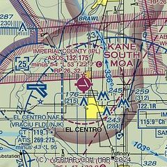
| Sectional chart |
|---|
|
| Airport distance calculator |
|---|
|
|
| Sunrise and sunset |
|---|
|
Times for 16-Apr-2024
| | Local
(UTC-7) | | Zulu
(UTC) |
|---|
| Morning civil twilight | | 05:46 | | 12:46 |
| Sunrise | | 06:11 | | 13:11 |
| Sunset | | 19:13 | | 02:13 |
| Evening civil twilight | | 19:38 | | 02:38 |
|
| Current date and time |
|---|
| Zulu (UTC) | 16-Apr-2024 10:17:59 |
|---|
| Local (UTC-7) | 16-Apr-2024 03:17:59 |
|---|
|
| METAR |
|---|
| KIPL | 160953Z AUTO 27004KT 10SM CLR 13/M01 A2995 RMK AO2 SLP142 T01281006 PWINO
|
KNJK
5nm W | 160956Z AUTO 29003KT 10SM CLR 13/M02 A2997 RMK AO2 SLP165 T01281017 $
|
|
| TAF |
|---|
| KIPL | 160520Z 1606/1706 VRB04KT P6SM SKC
|
KNJK
5nm W | 1607/1707 28009KT 9999 SKC QNH2994INS BECMG 1614/1616 VRB06KT 9999 FEW250 QNH2985INS BECMG 1703/1705 27009KT 9999 FEW250 QNH2988INS AUTOMATED SENSOR METWATCH 1607 TIL 1613 TX32/1622Z TN12/1613Z FS30233
|
|
| NOTAMs |
|---|
NOTAMs are issued by the DoD/FAA and will open in a separate window not controlled by AirNav.
|
|
