FAA INFORMATION EFFECTIVE 09 JULY 2026
Location
| FAA Identifier: | JYM |
| Lat/Long: | 41-55-16.6900N 084-35-12.1150W
41-55.278167N 084-35.201917W
41.9213028,-84.5866986
(estimated) |
| Elevation: | 1184.2 ft. / 361 m (estimated) |
| Variation: | 07W (2015) |
| From city: | 2 miles E of HILLSDALE, MI |
| Time zone: | UTC -4 (UTC -5 during Standard Time) |
| Zip code: | 49242 |
Airport Operations
| Airport use: | Open to the public |
| Activation date: | 10/1962 |
| Control tower: | no |
| ARTCC: | CLEVELAND CENTER |
| FSS: | LANSING FLIGHT SERVICE STATION |
| NOTAMs facility: | JYM (NOTAM-D service available) |
| Attendance: | MON-FRI 0800-1630, ALL SAT 0800-1200
UNATNDD MAJOR HOLS. |
| Wind indicator: | lighted |
| Segmented circle: | no |
| Lights: | ACTVT REIL RWY 10 & 28; PAPI RWY 10 & 28; HIRL RWY 10/28 - CTAF. |
| Beacon: | white-green (lighted land airport)
Operates sunset to sunrise. |
Airport Communications
| CTAF/UNICOM: | 122.8 |
| WX AWOS-3P: | 121.025 (517-437-5638) |
| TOLEDO APPROACH: | 134.35 |
| TOLEDO DEPARTURE: | 134.35 |
Nearby radio navigation aids
| NDB name | | Hdg/Dist | | Freq | | Var | | ID |
|---|
| ADRIAN | | 284/22.9 | | 278 | | 06W | | ADG | .- -.. --. |
| STURGIS | | 084/38.4 | | 382 | | 04W | | IRS | .. .-. ... |
Airport Services
| Fuel available: | 100LL JET-A
A:JET A FUEL TRUCK AVBL FOR SNGL POINT FUELING WHEN ATNDD.
100LL:100LL AVBL H24 SELF SVC. |
| Parking: | hangars and tiedowns |
| Airframe service: | MAJOR |
| Powerplant service: | MAJOR |
| Bottled oxygen: | NONE |
| Bulk oxygen: | NONE |
Runway Information
Runway 10/28
| Dimensions: | 5000 x 100 ft. / 1524 x 30 m |
| Surface: | asphalt/grooved, in good condition |
| Weight bearing capacity: | | Single wheel: | 36.0 | | Double wheel: | 75.0 |
|
| Runway edge lights: | high intensity |
| RUNWAY 10 | | RUNWAY 28 |
| Latitude: | 41-55.303445N | | 41-55.252770N |
| Longitude: | 084-35.751933W | | 084-34.651777W |
| Elevation: | 1155.1 ft. | | 1184.2 ft. |
| Traffic pattern: | left | | left |
| Runway heading: | 101 magnetic, 094 true | | 281 magnetic, 274 true |
| Markings: | nonprecision, in good condition | | nonprecision, in good condition |
| Visual slope indicator: | 4-light PAPI on left (3.00 degrees glide path) | | 4-light PAPI on left (3.00 degrees glide path) |
| Runway end identifier lights: | yes | | yes |
| Touchdown point: | yes, no lights | | yes, no lights |
| Obstructions: | 14 ft. tree, 553 ft. from runway, 304 ft. right of centerline, 25:1 slope to clear | | 9 ft. tree, 403 ft. from runway, 282 ft. left of centerline, 22:1 slope to clear |
Airport Ownership and Management from official FAA records
| Ownership: | Publicly-owned |
| Owner: | CITY OF HILLSDALE
97 N BROAD ST
HILLSDALE, MI 49242-1617
Phone 517-437-6444 |
| Manager: | TRAVIS STEBELTON
1727 AIRPORT RD
HILLSDALE, MI 49242-0400
Phone 517-797-4833 |
Additional Remarks
| - | DEER, LRG BIRDS, & WILDLIFE ON & INVOF ARPT. |
| - | CTC AMGR FOR SNOW REMOVAL & ARPT CONDS. |
| - | FOR CD CTC TOLEDO APCH AT 419-865-1495. |
Instrument Procedures
NOTE: All procedures below are presented as PDF files. If you need a reader for these files, you should download the free Adobe Reader.NOT FOR NAVIGATION. Please procure official charts for flight.
FAA instrument procedures published for use from 09 July 2026 at 0901Z to 06 August 2026 at 0900Z.
IAPs - Instrument Approach Procedures |
|---|
| RNAV (GPS) RWY 10 | |
download (170KB) |
| RNAV (GPS) RWY 28 | |
download (189KB) |
| NOTE: Special Take-Off Minimums/Departure Procedures apply | |
download (122KB) |
Other nearby airports with instrument procedures:
KOEB - Branch County Memorial Airport (21 nm W)
KJXN - Jackson County Airport/Reynolds Field (21 nm N)
KADG - Lenawee County Airport (23 nm E)
KRMY - Brooks Field Airport (26 nm NW)
0G6 - Williams County Airport (27 nm S)
|
|

Road maps at:
MapQuest
Bing
Google
| Aerial photo |
|---|
WARNING: Photo may not be current or correct

Do you have a better or more recent aerial photo of Hillsdale Municipal Airport that you would like to share? If so, please send us your photo.
|
| Sectional chart |
|---|
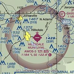
|
| Airport distance calculator |
|---|
|
|
| Sunrise and sunset |
|---|
|
Times for 28-Jul-2026
| | Local
(UTC-4) | | Zulu
(UTC) |
|---|
| Morning civil twilight | | 05:57 | | 09:57 |
| Sunrise | | 06:29 | | 10:29 |
| Sunset | | 21:01 | | 01:01 |
| Evening civil twilight | | 21:33 | | 01:33 |
|
| Current date and time |
|---|
| Zulu (UTC) | 28-Jul-2026 21:36:33 |
|---|
| Local (UTC-4) | 28-Jul-2026 17:36:33 |
|---|
|
| METAR |
|---|
| KJYM | 282115Z AUTO 35009KT 10SM BKN024 OVC032 25/19 A2981 RMK AO2
|
KOEB
20nm W | 282115Z AUTO 33007KT 10SM FEW028 25/19 A2981 RMK AO2
|
|
| TAF |
|---|
KJXN
21nm N | 281856Z 2819/2918 35010G20KT P6SM SCT018 BKN025 FM282100 36010G20KT P6SM SCT025 FM290100 01006KT P6SM FEW250
|
|
| NOTAMs |
|---|
NOTAMs are issued by the DoD/FAA and will open in a separate window not controlled by AirNav.
|
|

