FAA INFORMATION EFFECTIVE 09 JULY 2026
Location
| FAA Identifier: | K78 |
| Lat/Long: | 38-54-14.6000N 097-14-09.1000W
38-54.243333N 097-14.151667W
38.9040556,-97.2358611
(estimated) |
| Elevation: | 1152.9 ft. / 351.4 m (surveyed) |
| Variation: | 03E (2025) |
| From city: | 1 mile SW of ABILENE, KS |
| Time zone: | UTC -5 (UTC -6 during Standard Time) |
| Zip code: | 67410 |
Airport Operations
| Airport use: | Open to the public |
| Activation date: | 05/1946 |
| Control tower: | no |
| ARTCC: | KANSAS CITY CENTER |
| FSS: | WICHITA FLIGHT SERVICE STATION |
| NOTAMs facility: | ICT (NOTAM-D service available) |
| Attendance: | MON-SAT 0800-1700 |
| Wind indicator: | lighted |
| Segmented circle: | no |
| Lights: | MIRL RWY 18/36, PAPI RWY 18 & 36, REIL RWY 18 & 36 OPER DUSK-2200; OTHR TIMES ACTVT -- CTAF. |
| Beacon: | white-green (lighted land airport)
Operates sunset to sunrise. |
Airport Communications
| CTAF/UNICOM: | 122.8 |
| WX AWOS-3P: | 124.125 (785-802-8625) |
| MARSHALL AAF GCA APPROACH: | 121.25 |
| MARSHALL AAF GCA DEPARTURE: | 121.25 |
- APCH/DEP CTL SVC PRVDD BY KANSAS CITY ARTCC (ZKC) ON FREQS 134.9/363.2 (SALINA RCAG) WHEN MASHALL APCH CTL (FRI) CLSD.
Nearby radio navigation aids
| VOR radial/distance | | VOR name | | Freq | | Var |
|---|
| FRIr251/(17.9) | | FORT RILEY VOR | | 109.40 | | 06E |
| SLNr087/18.0 | | SALINA VORTAC | | 117.10 | | 07E |
| MHKr237/30.1 | | MANHATTAN VOR/DME | | 110.20 | | 04E |
| NDB name | | Hdg/Dist | | Freq | | Var | | ID |
|---|
| HERINGTON | | 297/23.6 | | 407 | | 06E | | HRU | .... .-. ..- |
Airport Services
| Fuel available: | 100LL
100LL:24 HR SELF SERVE FUEL. |
| Parking: | hangars and tiedowns |
| Airframe service: | MAJOR |
| Powerplant service: | MAJOR |
| Bottled oxygen: | NONE |
| Bulk oxygen: | NONE |
Runway Information
Runway 18/36
| Dimensions: | 4100 x 75 ft. / 1250 x 23 m |
| Surface: | concrete, in good condition |
| Weight bearing capacity: | | PCN 11 /R/C/X/U | | Single wheel: | 13.0 | | Double wheel: | 16.0 |
|
| Runway edge lights: | medium intensity |
| RUNWAY 18 | | RUNWAY 36 |
| Latitude: | 38-54.580945N | | 38-53.905485N |
| Longitude: | 097-14.150700W | | 097-14.151660W |
| Elevation: | 1152.9 ft. | | 1150.2 ft. |
| Traffic pattern: | left | | left |
| Runway heading: | 177 magnetic, 180 true | | 357 magnetic, 000 true |
| Displaced threshold: | 186 ft. | | no |
| Declared distances: | TORA:4100 TODA:4100 ASDA:4100 LDA:3914 | | TORA:4100 TODA:4100 ASDA:4100 LDA:4100 |
| Markings: | nonprecision, in good condition | | nonprecision, in good condition |
| Visual slope indicator: | 2-light PAPI on left (3.00 degrees glide path) | | 2-light PAPI on left (3.00 degrees glide path) |
| Runway end identifier lights: | yes
REIL: LOW/ MEDIUM/ HIGH PILOT CTLD. | | yes |
| Touchdown point: | yes, no lights | | yes, no lights |
| Obstructions: | 36 ft. trees, 745 ft. from runway, 370 ft. left and right of centerline, 15:1 slope to clear
OBSTN CLNC SLOPE 29:1 TO DSPLCD THLD. | | 15 ft. road, 746 ft. from runway, 319 ft. left of centerline, 36:1 slope to clear |
Airport Ownership and Management from official FAA records
| Ownership: | Publicly-owned |
| Owner: | CITY OF ABILENE KANSAS
CITY BUILDING, 419 N. BROADWAY
ABILENE, KS 67410
Phone 785-263-2550 |
| Manager: | JIM CURTIS
801 S. WASHINGTON
ABILENE, KS 67410
Phone 785-263-3970 |
Additional Remarks
| - | COURTESY CAR AVBL. |
| - | FOR CD CTC KANSAS CITY ARTCC AT 913-254-8508. |
Instrument Procedures
NOTE: All procedures below are presented as PDF files. If you need a reader for these files, you should download the free Adobe Reader.NOT FOR NAVIGATION. Please procure official charts for flight.
FAA instrument procedures published for use from 09 July 2026 at 0901Z to 06 August 2026 at 0900Z.
IAPs - Instrument Approach Procedures |
|---|
| RNAV (GPS) RWY 18 | |
download (265KB) |
| RNAV (GPS) RWY 36 **CHANGED** | |
download (233KB) |
| VOR-A | |
download (179KB) |
| NOTE: Special Take-Off Minimums/Departure Procedures apply | |
download (365KB) |
Other nearby airports with instrument procedures:
3JC - Freeman Field Airport (20 nm NE)
KSLN - Salina Regional Airport (21 nm W)
KHRU - Herington Regional Airport (24 nm SE)
KFRI - Marshall Army Airfield (24 nm E)
KCYW - Clay Center Municipal Airport (29 nm N)
|
|

Road maps at:
MapQuest
Bing
Google
| Aerial photo |
|---|
WARNING: Photo may not be current or correct
 Photo taken 29-Aug-2020
looking north.
Photo taken 29-Aug-2020
looking north.
Do you have a better or more recent aerial photo of Abilene Municipal Airport that you would like to share? If so, please send us your photo.
|
| Sectional chart |
|---|
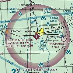
|
| Airport distance calculator |
|---|
|
|
| Sunrise and sunset |
|---|
|
Times for 24-Jul-2026
| | Local
(UTC-5) | | Zulu
(UTC) |
|---|
| Morning civil twilight | | 05:54 | | 10:54 |
| Sunrise | | 06:24 | | 11:24 |
| Sunset | | 20:47 | | 01:47 |
| Evening civil twilight | | 21:17 | | 02:17 |
|
| Current date and time |
|---|
| Zulu (UTC) | 24-Jul-2026 21:44:40 |
|---|
| Local (UTC-5) | 24-Jul-2026 16:44:40 |
|---|
|
| METAR |
|---|
KSLN
21nm W | 242053Z 18011KT 10SM BKN049 BKN065 32/23 A2994 RMK AO2 SLP122 T03220233 56019
|
KFRI
23nm E | 242140Z AUTO 18006KT 10SM BKN030 30/23 A2993 RMK AO2 SLP124
|
KMHK
29nm NE | 242052Z AUTO 21007KT 10SM FEW028 BKN036 OVC045 28/23 A2995 RMK AO2 SLP131 T02830228 56014
|
KMPR
39nm SW | 242135Z AUTO 18015G18KT 10SM SCT044 BKN060 31/23 A2996 RMK AO2 T03120229
|
|
| TAF |
|---|
KSLN
21nm W | 241831Z 2419/2518 19010G18KT P6SM BKN025 FM242100 19010G18KT P6SM BKN040 FM250100 15009KT P6SM FEW220 FM250900 19007KT P6SM SKC
|
KFRI
23nm E | 241200Z 2412/2518 10010KT 8000 -SHRA VCTS SCT020 OVC060 QNH3000INS BECMG 2413/2414 09010G15KT 9999 NSW FEW020 SCT060 BKN100 QNH3002INS TEMPO 2417/2418 VCTS BECMG 2501/2502 VRB05KT 9999 NSW SCT020 BKN060 QNH3004INS TX26/2420Z TN16/2511Z
|
|
| NOTAMs |
|---|
NOTAMs are issued by the DoD/FAA and will open in a separate window not controlled by AirNav.
|
|

