FAA INFORMATION EFFECTIVE 11 JUNE 2026
Location
| FAA Identifier: | AQR |
| Lat/Long: | 34-23-54.0200N 096-08-53.0150W
34-23.900333N 096-08.883583W
34.3983389,-96.1480597
(estimated) |
| Elevation: | 590 ft. / 179.8 m (surveyed) |
| Variation: | 06E (1985) |
| From city: | 1 mile NW of ATOKA, OK |
| Time zone: | UTC -5 (UTC -6 during Standard Time) |
| Zip code: | 74525 |
Airport Operations
| Airport use: | Open to the public |
| Activation date: | 02/1938 |
| Control tower: | no |
| ARTCC: | FORT WORTH CENTER |
| FSS: | MC ALESTER FLIGHT SERVICE STATION |
| NOTAMs facility: | AQR (NOTAM-D service available) |
| Attendance: | UNATNDD |
| Wind indicator: | yes |
| Segmented circle: | no |
| Lights: | MIRL RWY 18/36 OPS SS-SR; ACTVT PAPI RWY 18 - CTAF. |
| Beacon: | white-green (lighted land airport)
Operates sunset to sunrise. |
Airport Communications
| CTAF: | 122.9 |
| WX AWOS-3: | 121.125 (580-889-6924) |
Airport Services
| Fuel available: | 100LL
100LL:AVBL H24 HR WITH CREDIT CARD. |
| Parking: | tiedowns |
Runway Information
Runway 18/36
| Dimensions: | 3015 x 60 ft. / 919 x 18 m |
| Surface: | asphalt, in fair condition |
| Weight bearing capacity: | |
| Runway edge lights: | medium intensity |
| RUNWAY 18 | | RUNWAY 36 |
| Latitude: | 34-24.146833N | | 34-23.653833N |
| Longitude: | 096-08.845667W | | 096-08.921500W |
| Elevation: | 589.0 ft. | | 579.8 ft. |
| Traffic pattern: | left | | left |
| Runway heading: | 181 magnetic, 187 true | | 001 magnetic, 007 true |
| Displaced threshold: | 197 ft. | | 233 ft. |
| Declared distances: | TORA:3015 TODA:3015 ASDA:3015 LDA:2818 | | TORA:3015 TODA:3015 ASDA:3015 LDA:2782 |
| Markings: | basic, in good condition | | basic, in good condition |
| Visual slope indicator: | 2-light PAPI on left (3.00 degrees glide path) | | 2-light PAPI on left (3.00 degrees glide path)
PAPI UNUSBL BYD 6 DEGS LEFT & 9 DEGS RIGHT OF CNTRLN. |
| Touchdown point: | yes, no lights | | yes, no lights |
| Obstructions: | 25 ft. trees, 237 ft. from runway, 64 ft. right of centerline, 1:1 slope to clear
20 FT TREES EAST SIDE RWY 18 END. | | 46 ft. trees, 923 ft. from runway, 81 ft. right of centerline, 15:1 slope to clear
18 FT HWY 45 FT FM RWY END; 3 FT FENCE 10 FT FM RWY END APCH CLNC SLOPE 16:1 TO THLD. |
Airport Ownership and Management from official FAA records
| Ownership: | Publicly-owned |
| Owner: | CITY OF ATOKA
353 EAST A STREET, P. O. BOX 900, P. O. BOX 900
ATOKA, OK 74525
Phone 580-889-3341 |
| Manager: | DANNY DELAY
353 EAST A STREET, P. O. BOX 900
ATOKA, OK 74525
Phone 580-889-3341
580-889-3250. |
Additional Remarks
| - | FOR CD CTC FORT WORTH ARTCC AT 817-858-7584. |
Instrument Procedures
There are no published instrument procedures at KAQR.
Some nearby airports with instrument procedures:
80F - Antlers Municipal Airport (28 nm SE)
KDUA - Durant Regional Airport - Eaker Field (30 nm SW)
KMLC - Mc Alester Regional Airport (34 nm NE)
KADH - Ada Regional Airport (36 nm NW)
1F4 - Madill Municipal Airport (36 nm SW)
|
|

Road maps at:
MapQuest
Bing
Google
| Aerial photo |
|---|
WARNING: Photo may not be current or correct
 Photo submitted by NRS, Inc.
Taken in the Fall of 2007
Photo submitted by NRS, Inc.
Taken in the Fall of 2007
Do you have a better or more recent aerial photo of Atoka Municipal Airport that you would like to share? If so, please send us your photo.
|
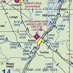
| Sectional chart |
|---|
|
| Airport distance calculator |
|---|
|
|
| Sunrise and sunset |
|---|
|
Times for 23-Jun-2026
| | Local
(UTC-5) | | Zulu
(UTC) |
|---|
| Morning civil twilight | | 05:45 | | 10:45 |
| Sunrise | | 06:14 | | 11:14 |
| Sunset | | 20:39 | | 01:39 |
| Evening civil twilight | | 21:09 | | 02:09 |
|
| Current date and time |
|---|
| Zulu (UTC) | 23-Jun-2026 05:45:29 |
|---|
| Local (UTC-5) | 23-Jun-2026 00:45:29 |
|---|
|
| TAF |
|---|
KDUA
30nm SW | 230252Z 2303/2324 06005KT P6SM VCSH SCT030 BKN050 PROB30 2304/2308 VRB30KT 2SM TSRA BKN015CB FM230800 VRB05KT P6SM SCT014 BKN280 PROB30 2309/2315 -TSRA BKN015CB FM231500 19007KT P6SM SCT015 SCT035 BKN250
|
KMLC
34nm NE | 221732Z 2218/2318 VRB05KT P6SM BKN035 FM230100 03004KT P6SM SCT040 BKN080 PROB30 2306/2311 5SM -TSRA BKN035CB FM231100 10005KT P6SM BKN015 BKN025 PROB30 2311/2316 5SM -TSRA BKN010CB AMD NOT SKED
|
|
| NOTAMs |
|---|
NOTAMs are issued by the DoD/FAA and will open in a separate window not controlled by AirNav.
|
|

