FAA INFORMATION EFFECTIVE 07 AUGUST 2025
Location
| FAA Identifier: | CAG |
| Lat/Long: | 40-29-42.8000N 107-31-18.0000W
40-29.713333N 107-31.300000W
40.4952222,-107.5216667
(estimated) |
| Elevation: | 6197.5 ft. / 1889.0 m (surveyed) |
| Variation: | 09E (2020) |
| From city: | 2 miles SE of CRAIG, CO |
| Time zone: | UTC -6 (UTC -7 during Standard Time) |
| Zip code: | 81625 |
Airport Operations
| Airport use: | Open to the public |
| Activation date: | 04/1940 |
| Control tower: | no |
| ARTCC: | DENVER CENTER |
| FSS: | DENVER FLIGHT SERVICE STATION |
| NOTAMs facility: | CAG (NOTAM-D service available) |
| Attendance: | MON-FRI 0800-1700, ALL SAT-SUN IRREG |
| Wind indicator: | lighted |
| Segmented circle: | yes |
| Lights: | ACTIVATE MIRL RY 07/25, REIL RYS 07 & 25 AND PAPI RY 25 - CTAF. |
| Beacon: | white-green (lighted land airport)
Operates sunset to sunrise. |
Airport Communications
| CTAF/UNICOM: | 122.8 |
| WX ASOS: | 135.425 (970-824-2373) |
| WX AWOS-3PT at HDN (14 nm E): | 119.275 (970-276-3690) |
- APCH/DEP CTL SVC PRVDD BY DENVER ARTCC (ZDV) ON FREQS 120.475/235.975 (HAYDEN RCAG).
Nearby radio navigation aids
| VOR radial/distance | | VOR name | | Freq | | Var |
|---|
| CHEr247/10.0 | | HAYDEN VOR/DME | | 115.60 | | 14E |
| BQZr261/29.7 | | ROBERT VOR/DME | | 112.20 | | 13E |
| EKRr027/31.6 | | MEEKER VOR/DME | | 115.20 | | 09E |
Airport Services
| Fuel available: | 100LL JET-A |
| Parking: | tiedowns |
| Bottled oxygen: | NONE |
| Bulk oxygen: | NONE |
Runway Information
Runway 7/25
| Dimensions: | 5606 x 100 ft. / 1709 x 30 m |
| Surface: | asphalt, in fair condition |
| Weight bearing capacity: | | PCN 12 /F/D/X/T | | Single wheel: | 35.0 | | Double wheel: | 40.0 |
|
| Runway edge lights: | medium intensity |
| RUNWAY 7 | | RUNWAY 25 |
| Latitude: | 40-29.656413N | | 40-29.768963N |
| Longitude: | 107-31.899802W | | 107-30.699785W |
| Elevation: | 6186.4 ft. | | 6197.3 ft. |
| Traffic pattern: | left | | left |
| Runway heading: | 074 magnetic, 083 true | | 254 magnetic, 263 true |
| Markings: | nonprecision, in fair condition | | nonprecision, in fair condition |
| Visual slope indicator: | | | 4-light PAPI on left (3.00 degrees glide path) |
| Runway end identifier lights: | yes | | yes |
| Touchdown point: | yes, no lights | | yes, no lights |
| Obstructions: | 97 ft. pline, 3872 ft. from runway, 190 ft. right of centerline, 37:1 slope to clear | | 43 ft. tree, 1180 ft. from runway, 189 ft. left of centerline, 22:1 slope to clear |
Airport Ownership and Management from official FAA records
| Ownership: | Publicly-owned |
| Owner: | MOFFAT CO
MOFFAT COUNTY COURTHOUSE
CRAIG, CO 81625
Phone 970-824-9148
COUNTY CONTACT JERRY HOBERG AT 970-824-9148. |
| Manager: | CANDACE MILLER
221 W VICTORY WAY
CRAIG, CO 81625
Phone 970-824-9148 |
Additional Remarks
| - | RY 25 HAS +10 FT ROAD 340 FT FM THLD OB, +41 FT TREES 1185 FT FM THLD 50 LEFT OF CNTRLN, +75 FT TREES 4000 FT FM THLD. |
| - | WILDLIFE ON AND INVOF ARPT. |
| - | COLD TEMPERATURE AIRPORT. ALTITUDE CORRECTION REQUIRED AT OR BELOW -27C. |
| - | FOR CD CTC DENVER ARTCC AT 303-651-4257. |
Instrument Procedures
NOTE: All procedures below are presented as PDF files. If you need a reader for these files, you should download the free Adobe Reader.NOT FOR NAVIGATION. Please procure official charts for flight.
FAA instrument procedures published for use from 07 August 2025 at 0901Z to 04 September 2025 at 0900z.
IAPs - Instrument Approach Procedures |
|---|
| RNAV (GPS) RWY 07 **CHANGED** | |
download (201KB) |
| RNAV (GPS) RWY 25 **CHANGED** | |
download (255KB) |
| VOR RWY 25 **CHANGED** | |
download (242KB) |
| NOTE: Special Alternate Minimums apply | |
download (145KB) |
| NOTE: Special Take-Off Minimums/Departure Procedures apply | |
download (105KB) |
Other nearby airports with instrument procedures:
KHDN - Yampa Valley Airport (14 nm E)
KSBS - Steamboat Springs Airport/Bob Adams Field (30 nm E)
KEEO - Meeker Coulter Field Airport (32 nm SW)
KDWX - Dixon Airport (33 nm N)
KEGE - Eagle County Regional Airport (58 nm SE)
|
|

Road maps at:
MapQuest
Bing
Google
| Aerial photo |
|---|
WARNING: Photo may not be current or correct
 Photo by Jeff Kaplan and Matt Beyer
Taken mid September 2015
looking east.
Photo by Jeff Kaplan and Matt Beyer
Taken mid September 2015
looking east.
Do you have a better or more recent aerial photo of Craig-Moffat Airport that you would like to share? If so, please send us your photo.
|
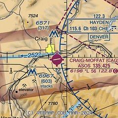
| Sectional chart |
|---|
|
| Airport distance calculator |
|---|
|
|
| Sunrise and sunset |
|---|
|
Times for 01-Sep-2025
| | Local
(UTC-6) | | Zulu
(UTC) |
|---|
| Morning civil twilight | | 06:10 | | 12:10 |
| Sunrise | | 06:38 | | 12:38 |
| Sunset | | 19:42 | | 01:42 |
| Evening civil twilight | | 20:10 | | 02:10 |
|
| Current date and time |
|---|
| Zulu (UTC) | 01-Sep-2025 23:08:45 |
|---|
| Local (UTC-6) | 01-Sep-2025 17:08:45 |
|---|
|
| METAR |
|---|
| KCAG | 012253Z AUTO VRB06KT 10SM CLR 28/M03 A3031 RMK AO2 SLP204 T02831028
|
KHDN
14nm E | 012256Z AUTO 24009KT 10SM CLR 27/M02 A3035 RMK AO2 SLP199 T02721017 $
|
|
| TAF |
|---|
KHDN
14nm E | 012031Z 0121/0218 25008KT 6SM HZ SKC FM020200 11006KT P6SM SKC FM020600 10012KT P6SM SKC
|
|
| NOTAMs |
|---|
NOTAMs are issued by the DoD/FAA and will open in a separate window not controlled by AirNav.
|
|


