FAA INFORMATION EFFECTIVE 16 APRIL 2026
Location
| FAA Identifier: | CAR |
| Lat/Long: | 46-52-17.9000N 068-01-05.5000W
46-52.298333N 068-01.091667W
46.8716389,-68.0181944
(estimated) |
| Elevation: | 620.3 ft. / 189.1 m (surveyed) |
| Variation: | 17W (2020) |
| From city: | 1 mile NW of CARIBOU, ME |
| Time zone: | UTC -4 (UTC -5 during Standard Time) |
| Zip code: | 04736 |
Airport Operations
| Airport use: | Open to the public |
| Activation date: | 04/1940 |
| Control tower: | no |
| ARTCC: | BOSTON CENTER |
| FSS: | BANGOR FLIGHT SERVICE STATION |
| NOTAMs facility: | CAR (NOTAM-D service available) |
| Attendance: | UNATNDD |
| Pattern altitude: | 1420.3 ft. MSL
800 FT AGL LGT ACFT; 1000 FT AGL MULTI & LRG SNGL ENG ACFT. |
| Wind indicator: | lighted |
| Segmented circle: | yes |
| Lights: | ACTVT MIRL RWY 01/19 & 11/29 - CTAF. |
| Beacon: | white-green (lighted land airport)
Operates sunset to sunrise. |
| International operations: | international airport of entry |
Airport Communications
| CTAF/UNICOM: | 122.8 |
| WX ASOS: | 135.125 (207-544-7089) |
| WX AWOS-3PT at PQI (11 nm S): | 118.025 (207-764-7248) |
- APCH/DEP SVC PRVDD BY BOSTON ARTCC ON FREQ 124.75/239.05 (CARIBOU RCAG).
- CLNC DEL PRVDD BY BOSTON ARTCC ON FREQ 124.75.
Nearby radio navigation aids
| VOR radial/distance | | VOR name | | Freq | | Var |
|---|
| PQIr049/6.6 | | PRESQUE ISLE VOR/DME | | 116.40 | | 21W |
Airport Services
| Fuel available: | 100LL
100LL:24 HR FUEL AVBL WITH CREDIT CARD. |
| Parking: | hangars and tiedowns |
| Airframe service: | NONE |
| Powerplant service: | NONE |
| Bottled oxygen: | NONE |
| Bulk oxygen: | NONE |
Runway Information
Runway 1/19
| Dimensions: | 4003 x 100 ft. / 1220 x 30 m |
| Surface: | asphalt, in good condition |
| Weight bearing capacity: | |
| Runway edge lights: | medium intensity |
| RUNWAY 1 | | RUNWAY 19 |
| Latitude: | 46-52.094295N | | 46-52.736680N |
| Longitude: | 068-00.896288W | | 068-01.107738W |
| Elevation: | 614.1 ft. | | 617.3 ft. |
| Traffic pattern: | left | | left |
| Runway heading: | 004 magnetic, 347 true | | 184 magnetic, 167 true |
| Markings: | nonprecision, in fair condition | | nonprecision, in fair condition |
| Touchdown point: | yes, no lights | | yes, no lights |
| Obstructions: | 7 ft. gnd, 201 ft. from runway, 149 ft. right of centerline, 1:1 slope to clear
GND 0-200 FT FM EOR 100-250 FT R OF CNTRLN RISING TO +8 FT. | | none |
Runway 11/29
| Dimensions: | 3016 x 75 ft. / 919 x 23 m |
| Surface: | asphalt, in fair condition |
| Weight bearing capacity: | |
| Runway edge lights: | medium intensity |
| RUNWAY 11 | | RUNWAY 29 |
| Latitude: | 46-52.130978N | | 46-52.152503N |
| Longitude: | 068-01.570345W | | 068-00.847520W |
| Elevation: | 620.0 ft. | | 619.3 ft. |
| Traffic pattern: | left | | left |
| Runway heading: | 105 magnetic, 088 true | | 285 magnetic, 268 true |
| Displaced threshold: | no | | 398 ft. |
| Markings: | basic, in good condition | | basic, in good condition |
| Runway end identifier lights: | no | | |
| Touchdown point: | yes, no lights | | yes, no lights |
| Obstructions: | none | | 34 ft. bldg, lighted, 398 ft. from runway, 95 ft. right of centerline, 5:1 slope to clear
GND ON BOTH SIDES RISING TO +3 FT 200 FT FM RWY END. |
Airport Ownership and Management from official FAA records
| Ownership: | Publicly-owned |
| Owner: | CITY OF CARIBOU
25 HIGH STREET
CARIBOU, ME 04736
Phone 207-493-3324 |
| Manager: | PENNY THOMPSON
25 HIGH STREET
CARIBOU, ME 04736
Phone 207-551-9442 |
Additional Remarks
| - | RWY 01/19 OBSTN LGTS ALG BOTH SIDES OF PRIM SFC AND TREE LN. |
| - | RWY 01 +23 FT PWR POLE AND +26 FT TREES, 950 FT FM THR ACRS APCH. |
| - | FOR CD IF UNA TO CTC ON FSS FREQ, CTC BOSTON ARTCC AT 603-879-6859 . |
Instrument Procedures
NOTE: All procedures below are presented as PDF files. If you need a reader for these files, you should download the free Adobe Reader.NOT FOR NAVIGATION. Please procure official charts for flight.
FAA instrument procedures published for use from 16 April 2026 at 0901Z to 14 May 2026 at 0900Z.
IAPs - Instrument Approach Procedures |
|---|
| RNAV (GPS) RWY 01 | |
download (232KB) |
| RNAV (GPS) RWY 19 | |
download (260KB) |
| NOTE: Special Alternate Minimums apply | |
download (145KB) |
| NOTE: Special Take-Off Minimums/Departure Procedures apply | |
download (548KB) |
Other nearby airports with instrument procedures:
KPQI - Presque Isle International Airport (11 nm S)
KFVE - Northern Aroostook Regional Airport (28 nm NW)
KHUL - Houlton International Airport (46 nm S)
KMLT - Millinocket Municipal Airport (78 nm S)
KLRG - Lincoln Regional Airport (93 nm S)
|
|

Road maps at:
MapQuest
Bing
Google
| Aerial photo |
|---|
WARNING: Photo may not be current or correct

Do you have a better or more recent aerial photo of Caribou Municipal Airport that you would like to share? If so, please send us your photo.
|
| Sectional chart |
|---|
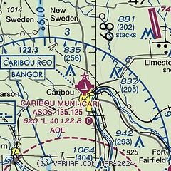
|
| Airport distance calculator |
|---|
|
|
| Sunrise and sunset |
|---|
|
Times for 09-May-2026
| | Local
(UTC-4) | | Zulu
(UTC) |
|---|
| Morning civil twilight | | 04:31 | | 08:31 |
| Sunrise | | 05:06 | | 09:06 |
| Sunset | | 19:51 | | 23:51 |
| Evening civil twilight | | 20:26 | | 00:26 |
|
| Current date and time |
|---|
| Zulu (UTC) | 09-May-2026 16:37:12 |
|---|
| Local (UTC-4) | 09-May-2026 12:37:12 |
|---|
|
| METAR |
|---|
| KCAR | 091554Z AUTO 20007G17KT 10SM BKN080 OVC100 12/M03 A2989 RMK AO2 RAB21E31 SLP129 P0000 T01171028
|
KPQI
12nm S | 091556Z AUTO 22012G15KT 10SM SCT070 SCT085 BKN100 13/M02 A2991 RMK AO2 SLP156 T01281022 $
|
|
| TAF |
|---|
| KCAR | 091120Z 0912/1012 22004KT P6SM SCT070 BKN100 FM091500 21008G15KT P6SM BKN060 FM100500 15008KT P6SM BKN015 FM100900 16010G19KT P6SM BCFG BKN007 WS020/20045KT
|
KPQI
12nm S | 091120Z 0912/1012 22004KT P6SM SCT070 BKN100 FM091500 20008G15KT P6SM BKN060 FM100500 15009KT P6SM BKN015 FM100800 16010G19KT P6SM BCFG BKN005 WS020/20045KT
|
|
| NOTAMs |
|---|
NOTAMs are issued by the DoD/FAA and will open in a separate window not controlled by AirNav.
|
|

