FAA INFORMATION EFFECTIVE 09 JULY 2026
Location
| FAA Identifier: | CHT |
| Lat/Long: | 39-46-55.2556N 093-29-46.4499W
39-46.920927N 093-29.774165W
39.7820154,-93.4962361
(estimated) |
| Elevation: | 783.3 ft. / 238.7 m (surveyed) |
| Variation: | 03E (1995) |
| From city: | 3 miles E of CHILLICOTHE, MO |
| Time zone: | UTC -5 (UTC -6 during Standard Time) |
| Zip code: | 64601 |
Airport Operations
| Airport use: | Open to the public |
| Activation date: | 09/1946 |
| Control tower: | no |
| ARTCC: | KANSAS CITY CENTER |
| FSS: | COLUMBIA FLIGHT SERVICE STATION |
| NOTAMs facility: | COU (NOTAM-D service available) |
| Attendance: | MON-FRI 0800-1700, ALL SAT 0800-1200 |
| Wind indicator: | yes |
| Segmented circle: | yes |
| Lights: | ACTVT REIL RWYS 14 & 32; PAPI RWYS 14 & 32; MIRL RWY 14 & 32 - CTAF. |
| Beacon: | white-green (lighted land airport)
Operates sunset to sunrise. |
Airport Communications
| CTAF/UNICOM: | 122.8 |
| WX AWOS-3: | 118.175 (660-646-0713) |
- APCH/DEP SVC PRVDD BY KANSAS CITY ARTCC ON FREQS 125.25/235.975 (CHILLICOTHE RCAG).
Nearby radio navigation aids
| VOR radial/distance | | VOR name | | Freq | | Var |
|---|
| BQSr060/19.7 | | BRAYMER VOR/DME | | 115.35 | | 03E |
Airport Services
| Fuel available: | 100LL |
| Parking: | hangars and tiedowns |
| Bottled oxygen: | NONE |
| Bulk oxygen: | NONE |
Runway Information
Runway 14/32
| Dimensions: | 3899 x 75 ft. / 1188 x 23 m |
| Surface: | concrete, in excellent condition |
| Weight bearing capacity: | | PCN 11 /R/C/W/T | | Single wheel: | 33.0 | | Double wheel: | 44.5 |
|
| Runway edge lights: | medium intensity |
| RUNWAY 14 | | RUNWAY 32 |
| Latitude: | 39-47.186573N | | 39-46.671765N |
| Longitude: | 093-29.989485W | | 093-29.492022W |
| Elevation: | 782.9 ft. | | 763.5 ft. |
| Traffic pattern: | left | | left |
| Runway heading: | 140 magnetic, 143 true | | 320 magnetic, 323 true |
| Markings: | nonprecision, in good condition | | nonprecision, in good condition |
| Visual slope indicator: | 4-light PAPI on left (3.00 degrees glide path) | | 4-light PAPI on right (3.50 degrees glide path) |
| Runway end identifier lights: | yes | | yes |
| Touchdown point: | yes, no lights | | yes, no lights |
Runway 2/20
| Dimensions: | 3503 x 110 ft. / 1068 x 34 m |
| Surface: | turf, in good condition |
| Runway edge markings: | RWY 02/20 MARKED WITH LARGE YELLOW CONES. DSPLCD THRS MARKED WITH 3 LARGE YELLOW CONES ON EACH SIDE OF RWY. |
| RUNWAY 2 | | RUNWAY 20 |
| Latitude: | 39-46.651397N | | 39-47.170562N |
| Longitude: | 093-29.974465W | | 093-29.648245W |
| Elevation: | 756.9 ft. | | 772.4 ft. |
| Traffic pattern: | left | | left |
| Runway heading: | 023 magnetic, 026 true | | 203 magnetic, 206 true |
| Displaced threshold: | 206 ft. | | 389 ft. |
| Markings: | , in good condition | | |
| Touchdown point: | yes, no lights | | yes, no lights |
| Obstructions: | none
RWY 20 - 23:1 BASED ON DSPLCD THR | | 39 ft. tree, 544 ft. from runway, 130 ft. left of centerline, 13:1 slope to clear |
Airport Ownership and Management from official FAA records
| Ownership: | Publicly-owned |
| Owner: | CITY OF CHILLICOTHE
715 WASHINGTON
CHILLICOTHE, MO 64601
Phone 660-646-1877 |
| Manager: | TOBY CALIVERE
13844 LIV 253
CHILLICOTHE, MO 64601
Phone 660-646-5270 |
Additional Remarks
| - | WILDLIFE, MIGRATORY BIRDS & GEESE ON & INVOF ARPT. |
| - | NTSD RWY SAFETY AREA BYND BOTH ENDS OF RWY 02/20; INCORRECT TERRAIN GRADES AND CROPS. |
| - | PAEW INVOF ARPT. |
| - | FOR CD IF UNA TO CTC ON FSS FREQ, CTC KANSAS CITY ARTCC AT 913-254-8508. |
Instrument Procedures
NOTE: All procedures below are presented as PDF files. If you need a reader for these files, you should download the free Adobe Reader.NOT FOR NAVIGATION. Please procure official charts for flight.
FAA instrument procedures published for use from 09 July 2026 at 0901Z to 06 August 2026 at 0900Z.
IAPs - Instrument Approach Procedures |
|---|
| RNAV (GPS) RWY 14 | |
download (197KB) |
| RNAV (GPS) RWY 32 | |
download (248KB) |
| NOTE: Special Take-Off Minimums/Departure Procedures apply | |
download (158KB) |
Other nearby airports with instrument procedures:
KTRX - Trenton Municipal Airport (19 nm N)
MO8 - North Central Missouri Regional Airport (22 nm E)
KEZZ - Cameron Memorial Airport (36 nm W)
3EX - Excelsior Springs Memorial Airport (42 nm SW)
KMHL - Marshall Memorial Municipal Airport (43 nm S)
|
|

Road maps at:
MapQuest
Bing
Google
| Aerial photo |
|---|
WARNING: Photo may not be current or correct

Do you have a better or more recent aerial photo of Chillicothe Municipal Airport that you would like to share? If so, please send us your photo.
|
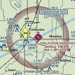
| Sectional chart |
|---|
|
| Airport distance calculator |
|---|
|
|
| Sunrise and sunset |
|---|
|
Times for 22-Jul-2026
| | Local
(UTC-5) | | Zulu
(UTC) |
|---|
| Morning civil twilight | | 05:34 | | 10:34 |
| Sunrise | | 06:05 | | 11:05 |
| Sunset | | 20:36 | | 01:36 |
| Evening civil twilight | | 21:07 | | 02:07 |
|
| Current date and time |
|---|
| Zulu (UTC) | 22-Jul-2026 07:59:10 |
|---|
| Local (UTC-5) | 22-Jul-2026 02:59:10 |
|---|
|
| METAR |
|---|
KCDJ
5nm NW | 220751Z AUTO 34003KT 18/17 A3005 RMK AO1 SLP163 T01830167
|
|
| NOTAMs |
|---|
NOTAMs are issued by the DoD/FAA and will open in a separate window not controlled by AirNav.
|
|

