FAA INFORMATION EFFECTIVE 16 APRIL 2026
Location
| FAA Identifier: | CPP |
| Lat/Long: | 33-35-52.6920N 083-08-17.7370W
33-35.878200N 083-08.295617W
33.5979700,-83.1382603
(estimated) |
| Elevation: | 688.5 ft. / 209.9 m (surveyed) |
| Variation: | 05W (2000) |
| From city: | 3 miles NE of GREENSBORO, GA |
| Time zone: | UTC -4 (UTC -5 during Standard Time) |
| Zip code: | 30642 |
Airport Operations
| Airport use: | Open to the public |
| Activation date: | 10/1975 |
| Control tower: | no |
| ARTCC: | ATLANTA CENTER |
| FSS: | MACON FLIGHT SERVICE STATION |
| NOTAMs facility: | MCN (NOTAM-D service available) |
| Attendance: | 0800-1700 |
| Wind indicator: | lighted |
| Segmented circle: | yes |
| Lights: | HIRL RWY 07/25 PRESET MED INTST DUSK-DAWN. TO INCR INTST OR ACTVT PAPI RWY 07 & 25; HIRL RWY 07/25 - CTAF. |
| Beacon: | white-green (lighted land airport)
Operates sunset to sunrise. |
Airport Communications
| CTAF/UNICOM: | 122.8 |
| WX AWOS-3: | 124.525 (706-453-0017) |
| ATLANTA APPROACH: | 132.475 ;0615-2200 |
| ATLANTA DEPARTURE: | 132.475 ;0615-2200 |
| WX AWOS-3 at IIY (19 nm NE): | 118.375 (706-678-3647) |
- APCH/DEP SVC PRVDD BY ATLANTA TRACON 0615-2200 ON FREQS 132.475/291.1 OTHER TIMES BY ATLANTA ARTCC ON FREQS 127.5/316.05 (ATHENS RCAG).
Nearby radio navigation aids
| VOR radial/distance | | VOR name | | Freq | | Var |
|---|
| AHNr156/22.9 | | ATHENS VOR/DME | | 116.95 | | 00E |
| NDB name | | Hdg/Dist | | Freq | | Var | | ID |
|---|
| JUNNE | | 248/6.5 | | 353 | | 05W | | VV | ...- ...- |
| BARROW COUNTY | | 137/30.3 | | 404 | | 05W | | BMW | -... -- .-- |
Airport Services
| Fuel available: | 100LL JET-A+
100LL:SELF FUEL WITH CREDIT CARD AVBL 0800-1700, FULL SVC AVBL 0800-1700, AFTER HOURS CALL 706-453-2715 OR 706-817-8226. |
| Parking: | tiedowns |
| Airframe service: | NONE |
| Powerplant service: | NONE |
| Bottled oxygen: | NONE |
| Bulk oxygen: | NONE |
Runway Information
Runway 7/25
| Dimensions: | 5500 x 100 ft. / 1676 x 30 m |
| Surface: | asphalt, in good condition |
| Weight bearing capacity: | | Single wheel: | 33.0 | | Double wheel: | 50.0 | | Double tandem: | 80.0 |
|
| Runway edge lights: | high intensity |
| RUNWAY 7 | | RUNWAY 25 |
| Latitude: | 33-35.680130N | | 33-36.076227N |
| Longitude: | 083-08.782900W | | 083-07.808285W |
| Elevation: | 677.7 ft. | | 688.5 ft. |
| Traffic pattern: | left | | left |
| Runway heading: | 069 magnetic, 064 true | | 249 magnetic, 244 true |
| Displaced threshold: | 99 ft. | | no |
| Declared distances: | TORA:5500 TODA:5500 ASDA:5500 LDA:5401 | | TORA:5500 TODA:5500 ASDA:5500 LDA:5500 |
| Markings: | nonprecision, in good condition | | nonprecision, in good condition |
| Visual slope indicator: | 2-light PAPI on left (3.00 degrees glide path) | | 4-light PAPI on left (3.00 degrees glide path) |
| Touchdown point: | yes, no lights | | yes, no lights |
| Instrument approach: | | | LOC/DME |
| Obstructions: | 27 ft. trees, 201 ft. from runway, 215 ft. right of centerline
FENCE 20 FT TREES 100 FT FM E.O.R, 200 FT RIGHT. | | 65 ft. trees, 1110 ft. from runway, 359 ft. right of centerline, 14:1 slope to clear |
Airport Ownership and Management from official FAA records
| Ownership: | Publicly-owned |
| Owner: | GREENE COUNTY
1034 SILVER DRIVE
GREENSBORO, GA 30642
Phone 706-453-7716 |
| Manager: | BYRON LOMBARD
1034 SILVER DRIVE
GREENSBORO, GA 30642
Phone (706) 453-2715
FAX 706-453-7108. |
Additional Remarks
| - | GCO AVBL ON FREQ 121.725 ATL APP OR 678-364-6131 (PREFERRED). |
| - | DEER ON & INVOF ARPT. |
Instrument Procedures
NOTE: All procedures below are presented as PDF files. If you need a reader for these files, you should download the free Adobe Reader.NOT FOR NAVIGATION. Please procure official charts for flight.
FAA instrument procedures published for use from 16 April 2026 at 0901Z to 14 May 2026 at 0900Z.
IAPs - Instrument Approach Procedures |
|---|
| RNAV (GPS) RWY 07 **CHANGED** | |
download (187KB) |
| RNAV (GPS) RWY 25 **CHANGED** | |
download (219KB) |
| LOC RWY 25 **CHANGED** | |
download (205KB) |
| VOR-B **CHANGED** | |
download (168KB) |
| NOTE: Special Alternate Minimums apply | |
download (160KB) |
| NOTE: Special Take-Off Minimums/Departure Procedures apply | |
download (510KB) |
Other nearby airports with instrument procedures:
52A - Madison Municipal Airport (16 nm W)
KIIY - Washington/Wilkes County Airport (19 nm NE)
KAHN - Athens/Ben Epps Airport (23 nm NW)
KMLJ - Baldwin County Regional Airport (27 nm S)
D73 - Cy Nunnally Memorial Airport (30 nm W)
|
|

Road maps at:
MapQuest
Bing
Google
| Aerial photo |
|---|
WARNING: Photo may not be current or correct
 Photo by Mathew Jenkinson
Photo taken 05-Nov-2020
looking south.
Photo by Mathew Jenkinson
Photo taken 05-Nov-2020
looking south.
Do you have a better or more recent aerial photo of Greene County Regional Airport that you would like to share? If so, please send us your photo.
|
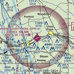
| Sectional chart |
|---|
|
CAUTION: Diagram may not be current

| Airport distance calculator |
|---|
|
|
| Sunrise and sunset |
|---|
|
Times for 21-Apr-2026
| | Local
(UTC-4) | | Zulu
(UTC) |
|---|
| Morning civil twilight | | 06:30 | | 10:30 |
| Sunrise | | 06:56 | | 10:56 |
| Sunset | | 20:07 | | 00:07 |
| Evening civil twilight | | 20:33 | | 00:33 |
|
| Current date and time |
|---|
| Zulu (UTC) | 21-Apr-2026 17:31:45 |
|---|
| Local (UTC-4) | 21-Apr-2026 13:31:45 |
|---|
|
| METAR |
|---|
| KCPP | 211715Z AUTO 05007G12KT 010V070 10SM CLR 22/02 A3036 RMK AO2
|
KIIY
20nm NE | 211715Z AUTO 36004KT 10SM CLR 22/00 A3037 RMK AO2 T02190001
|
|
| TAF |
|---|
KAHN
23nm NW | 211123Z 2112/2212 05003KT P6SM SKC FM211500 07007KT P6SM SKC FM212300 VRB02KT P6SM SKC
|
|
| NOTAMs |
|---|
NOTAMs are issued by the DoD/FAA and will open in a separate window not controlled by AirNav.
|
|


