FAA INFORMATION EFFECTIVE 27 NOVEMBER 2025
Location
| FAA Identifier: | DEQ |
| Lat/Long: | 34-02-49.2000N 094-23-57.7000W
34-02.820000N 094-23.961667W
34.0470000,-94.3993611
(estimated) |
| Elevation: | 354.8 ft. / 108.1 m (surveyed) |
| Variation: | 04E (2000) |
| From city: | 3 miles W of DE QUEEN, AR |
| Time zone: | UTC -6 (UTC -5 during Daylight Saving Time) |
| Zip code: | 71832 |
Airport Operations
| Airport use: | Open to the public |
| Activation date: | 05/1970 |
| Control tower: | no |
| ARTCC: | FORT WORTH CENTER |
| FSS: | JONESBORO FLIGHT SERVICE STATION |
| NOTAMs facility: | DEQ (NOTAM-D service available) |
| Attendance: | UNATNDD |
| Wind indicator: | lighted |
| Segmented circle: | yes |
| Lights: | DUSK-DAWN. ACTVT REIL RWY 08 & 26; PAPI RWY 08 & 26; MIRL RWY 08/26 - CTAF. |
| Beacon: | white-green (lighted land airport)
Operates sunset to sunrise. |
| Taxiway lights: | TWY EXIT SIGNS. |
Airport Communications
| CTAF/UNICOM: | 122.8 |
| WX ASOS: | 134.075 (870-642-7829) |
- APCH/DEP CTL SVC PRVDD BY FORT WORTH ARTCC (ZFW) ON FREQS 123.925/269.475 (TEXARKANA RCAG).
Nearby radio navigation aids
| VOR radial/distance | | VOR name | | Freq | | Var |
|---|
| TXKr326/35.9 | | TEXARKANA VORTAC | | 116.30 | | 07E |
| PGOr161/39.4 | | RICH MOUNTAIN VORTAC | | 113.50 | | 04E |
Airport Services
| Fuel available: | 100LL JET-A
100LL:FUEL AVBL 24 HR SELF SERVE WITH MAJOR CC (100LL & JET A) |
| Parking: | hangars and tiedowns |
| Airframe service: | NONE |
| Powerplant service: | NONE |
Runway Information
Runway 8/26
| Dimensions: | 5001 x 75 ft. / 1524 x 23 m |
| Surface: | asphalt, in good condition |
| Weight bearing capacity: | |
| Runway edge lights: | medium intensity |
| RUNWAY 8 | | RUNWAY 26 |
| Latitude: | 34-02.772677N | | 34-02.866472N |
| Longitude: | 094-24.454073W | | 094-23.469952W |
| Elevation: | 348.8 ft. | | 354.8 ft. |
| Traffic pattern: | left | | left |
| Runway heading: | 079 magnetic, 083 true | | 259 magnetic, 263 true |
| Markings: | nonprecision, in good condition | | nonprecision, in good condition |
| Visual slope indicator: | 2-light PAPI on left (3.00 degrees glide path) | | 2-light PAPI on left (3.00 degrees glide path) |
| Runway end identifier lights: | yes | | yes |
| Touchdown point: | yes, no lights | | yes, no lights |
| Obstructions: | 25 ft. tree, 1075 ft. from runway, 10 ft. right of centerline, 35:1 slope to clear | | 45 ft. trees, 1500 ft. from runway, 400 ft. right of centerline, 28:1 slope to clear
+6 FT FENCE 198 FT FM RY END 100 FT L. |
Airport Ownership and Management from official FAA records
| Ownership: | Publicly-owned |
| Owner: | SEVIER COUNTY
115 N. 3RD STREET
DEQUEEN, AR 71832
Phone 870-642-2425 |
| Manager: | SCOTT SIMMONS
PO BOX 206
DEQUEEN, AR 71832
Phone 870-582-2492
SECONDARY PHONE #: 870-582-5414 |
Additional Remarks
| - | FOR CD CTC FORT WORTH ARTCC AT 817-858-7584. |
Instrument Procedures
NOTE: All procedures below are presented as PDF files. If you need a reader for these files, you should download the free Adobe Reader.NOT FOR NAVIGATION. Please procure official charts for flight.
FAA instrument procedures published for use from 27 November 2025 at 0901Z to 25 December 2025 at 0900Z.
IAPs - Instrument Approach Procedures |
|---|
| RNAV (GPS) RWY 08 | |
download (212KB) |
| NOTE: Special Alternate Minimums apply | |
download (15KB) |
| NOTE: Special Take-Off Minimums/Departure Procedures apply | |
download (401KB) |
Other nearby airports with instrument procedures:
4O4 - Mc Curtain County Regional Airport (24 nm W)
M77 - Howard County Airport (28 nm E)
KMEZ - Mena Intermountain Municipal Airport (31 nm N)
KTXK - Texarkana Regional Airport-Webb Field (41 nm SE)
M18 - Hope Municipal Airport (42 nm SE)
|
|

Road maps at:
MapQuest
Bing
Google
| Aerial photo |
|---|
WARNING: Photo may not be current or correct
 Photo courtesy of the Arkansas Department of Aeronautics
Taken in the Spring of 2007
Photo courtesy of the Arkansas Department of Aeronautics
Taken in the Spring of 2007
Do you have a better or more recent aerial photo of J Lynn Helms Sevier County Airport that you would like to share? If so, please send us your photo.
|
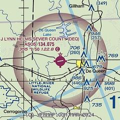
| Sectional chart |
|---|
|
| Airport distance calculator |
|---|
|
|
| Sunrise and sunset |
|---|
|
Times for 04-Dec-2025
| | Local
(UTC-6) | | Zulu
(UTC) |
|---|
| Morning civil twilight | | 06:41 | | 12:41 |
| Sunrise | | 07:09 | | 13:09 |
| Sunset | | 17:07 | | 23:07 |
| Evening civil twilight | | 17:35 | | 23:35 |
|
| Current date and time |
|---|
| Zulu (UTC) | 04-Dec-2025 14:40:32 |
|---|
| Local (UTC-6) | 04-Dec-2025 08:40:32 |
|---|
|
| METAR |
|---|
| KDEQ | 041353Z AUTO 04006KT 10SM OVC070 04/02 A3023 RMK AO2 SLP237 T00440022
|
|
| TAF |
|---|
KTXK
41nm SE | 041120Z 0412/0512 05007KT 6SM -DZ BR OVC007 FM041500 05007KT 4SM -RADZ BR OVC007 TEMPO 0416/0420 2SM -RADZ BR OVC004 FM042200 05007KT 6SM BR OVC010 FM050600 04003KT 4SM BR OVC007
|
|
| NOTAMs |
|---|
NOTAMs are issued by the DoD/FAA and will open in a separate window not controlled by AirNav.
|
|

