FAA INFORMATION EFFECTIVE 09 JULY 2026
Location
| FAA Identifier: | DGW |
| Lat/Long: | 42-47-49.9000N 105-23-09.0000W
42-47.831667N 105-23.150000W
42.7971944,-105.3858333
(estimated) |
| Elevation: | 4932.7 ft. / 1503.5 m (surveyed) |
| Variation: | 11E (2005) |
| From city: | 3 miles N of DOUGLAS, WY |
| Time zone: | UTC -6 (UTC -7 during Standard Time) |
| Zip code: | 82633 |
Airport Operations
| Airport use: | Open to the public |
| Activation date: | 09/1984 |
| Control tower: | no |
| ARTCC: | DENVER CENTER |
| FSS: | CASPER FLIGHT SERVICE STATION |
| NOTAMs facility: | DGW (NOTAM-D service available) |
| Attendance: | MON-FRI 0630-1700, ALL SAT-SUN 0800-1700 |
| Wind indicator: | lighted |
| Segmented circle: | yes |
| Lights: | ACTVT REIL RWYS 11 AND 29; MIRL RWY 05/23 &11/29 DALGT HRS - 122.8. MIRL RWY 05/23 & 11/29 PRESET TO LOW INTST DARK HRS, TO INCR INTST - 122.8. PAPI RWY 11, 23 & 29 OPR CONSLY. |
| Beacon: | white-green (lighted land airport)
Operates sunset to sunrise. |
Airport Communications
| CTAF/UNICOM: | 122.8 |
| WX ASOS: | 135.225 (307-358-4448) |
- APCH/DEP CTL SVC PRVDD BY DENVER ARTCC (ZDV) ON FREQS 135.6/363.025 (LUSK RCAG).
Nearby radio navigation aids
| VOR radial/distance | | VOR name | | Freq | | Var |
|---|
| IIPr304/10.1 | | HIPSHER VOR/DME | | 115.75 | | 12E |
Airport Services
| Fuel available: | 100LL JET-A
100LL:FUEL AFT HRS SEE PHONE NRS POSTED IN TRML LOBBY. CALL OUT FEE WILL APPLY. |
| Parking: | hangars and tiedowns |
| Airframe service: | MAJOR |
| Powerplant service: | MAJOR |
| Bottled oxygen: | NONE |
| Bulk oxygen: | NONE |
Runway Information
Runway 11/29
| Dimensions: | 6534 x 100 ft. / 1992 x 30 m |
| Surface: | asphalt, in good condition |
| Runway edge lights: | medium intensity |
| RUNWAY 11 | | RUNWAY 29 |
| Latitude: | 42-47.929178N | | 42-47.426718N |
| Longitude: | 105-23.594783W | | 105-22.303817W |
| Elevation: | 4909.6 ft. | | 4932.7 ft. |
| Traffic pattern: | left | | left |
| Runway heading: | 107 magnetic, 118 true | | 287 magnetic, 298 true |
| Markings: | nonprecision, in good condition | | nonprecision, in good condition |
| Visual slope indicator: | 2-light PAPI on left (3.00 degrees glide path) | | 2-light PAPI on left (3.00 degrees glide path) |
| Runway end identifier lights: | yes | | yes |
| Touchdown point: | yes, no lights | | yes, no lights |
Runway 5/23
| Dimensions: | 4760 x 75 ft. / 1451 x 23 m |
| Surface: | gravel/dirt, in good condition
ASPH REMOVED & CONVERTED TO A TREATED BASE SFC 2019. |
| Weight bearing capacity: | |
| Runway edge lights: | medium intensity |
| RUNWAY 5 | | RUNWAY 23 |
| Latitude: | 42-47.886825N | | 42-48.194963N |
| Longitude: | 105-23.913627W | | 105-22.935473W |
| Elevation: | 4901.6 ft. | | 4913.8 ft. |
| Traffic pattern: | left | | left |
| Runway heading: | 056 magnetic, 067 true | | 236 magnetic, 247 true |
| Visual slope indicator: | | | 2-light PAPI on left (3.00 degrees glide path) |
| Touchdown point: | yes, no lights | | yes, no lights |
| Obstructions: | none | | 116 ft. hill, 2925 ft. from runway, 175 ft. right of centerline, 23:1 slope to clear |
Airport Ownership and Management from official FAA records
| Ownership: | Publicly-owned |
| Owner: | CONVERSE COUNTY
PO BOX 774
DOUGLAS, WY 82633
Phone 307-358-4924 |
| Manager: | STEVE GOOD
P O BOX 774
DOUGLAS, WY 82633
Phone 307-358-4924 |
Additional Remarks
| - | WILDLIFE ON & INVOF ARPT. |
| - | RETRO-REFLECTIVE MKRS ALG ALL TWYS. |
| - | FOR CD IF UNA TO CTC ON FSS FREQ, CTC DENVER ARTCC AT 303-651-4257. |
Instrument Procedures
NOTE: All procedures below are presented as PDF files. If you need a reader for these files, you should download the free Adobe Reader.NOT FOR NAVIGATION. Please procure official charts for flight.
FAA instrument procedures published for use from 09 July 2026 at 0901Z to 06 August 2026 at 0900Z.
IAPs - Instrument Approach Procedures |
|---|
| RNAV (GPS) RWY 11 | |
download (225KB) |
| RNAV (GPS) RWY 29 | |
download (247KB) |
| VOR RWY 29 | |
download (257KB) |
| NOTE: Special Alternate Minimums apply | |
download (208KB) |
| NOTE: Special Take-Off Minimums/Departure Procedures apply | |
download (223KB) |
Other nearby airports with instrument procedures:
KGUR - Camp Guernsey Airport (43 nm SE)
KCPR - Casper/Natrona County International Airport (48 nm W)
KEAN - Phifer Airfield (49 nm SE)
KTOR - Torrington Municipal Airport (70 nm SE)
KECS - Mondell Field Airport (80 nm NE)
|
|

Road maps at:
MapQuest
Bing
Google
| Aerial photo |
|---|
WARNING: Photo may not be current or correct
 Photo by Mike Terpstra
Photo taken 21-Jul-2011
looking east.
Photo by Mike Terpstra
Photo taken 21-Jul-2011
looking east.
Do you have a better or more recent aerial photo of Converse County Airport that you would like to share? If so, please send us your photo.
|
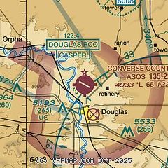
| Sectional chart |
|---|
|
| Airport distance calculator |
|---|
|
|
| Sunrise and sunset |
|---|
|
Times for 19-Jul-2026
| | Local
(UTC-6) | | Zulu
(UTC) |
|---|
| Morning civil twilight | | 05:08 | | 11:08 |
| Sunrise | | 05:41 | | 11:41 |
| Sunset | | 20:34 | | 02:34 |
| Evening civil twilight | | 21:08 | | 03:08 |
|
| Current date and time |
|---|
| Zulu (UTC) | 19-Jul-2026 21:34:25 |
|---|
| Local (UTC-6) | 19-Jul-2026 15:34:25 |
|---|
|
| METAR |
|---|
| KDGW | 192053Z AUTO 31007KT 10SM BKN110 34/08 A3004 RMK AO2 SLP094 T03440083 58014 $
|
|
| TAF |
|---|
KCPR
48nm W | 191720Z 1918/2018 32010KT P6SM FEW120 FM192200 01008KT P6SM SCT100 SCT120 FM200100 06010KT P6SM SCT120 FM200600 32007KT P6SM FEW150 FM201200 26006KT P6SM SKC FM201700 36010G16KT P6SM FEW120
|
|
| NOTAMs |
|---|
NOTAMs are issued by the DoD/FAA and will open in a separate window not controlled by AirNav.
|
|

