FAA INFORMATION EFFECTIVE 07 AUGUST 2025
Location
| FAA Identifier: | DWU |
| Lat/Long: | 38-33-16.0590N 082-44-15.5830W
38-33.267650N 082-44.259717W
38.5544608,-82.7376619
(estimated) |
| Elevation: | 546.7 ft. / 166.6 m (surveyed) |
| Variation: | 05W (1995) |
| From city: | 6 miles NW of ASHLAND, KY |
| Time zone: | UTC -4 (UTC -5 during Standard Time) |
| Zip code: | 41183 |
Airport Operations
| Airport use: | Open to the public |
| Activation date: | 10/1948 |
| Control tower: | no |
| ARTCC: | INDIANAPOLIS CENTER |
| FSS: | LOUISVILLE FLIGHT SERVICE STATION |
| NOTAMs facility: | LOU (NOTAM-D service available) |
| Attendance: | 0800-1800 |
| Wind indicator: | lighted |
| Segmented circle: | yes |
| Lights: | ACTVT REIL RWY 10 & 28; MIRL RWY 10/28 - CTAF. PAPI RWY 10 & 28 ON CONSLY. |
| Beacon: | white-green (lighted land airport)
Operates sunset to sunrise. |
| Landing fee: | yes |
Airport Communications
| CTAF/UNICOM: | 122.8 |
| WX AWOS-3PT: | 132.425 (606-836-2682) |
| HUNTINGTON APPROACH: | 128.4 |
| HUNTINGTON DEPARTURE: | 128.4 |
| CLEARANCE DELIVERY: | 121.7 |
| WX ASOS at HTS (14 nm SE): | PHONE 681-432-1499 |
| WX AWOS-3 at PMH (18 nm N): | 125.175 (740-820-2500) |
Airport Services
| Fuel available: | 100LL JET-A |
| Parking: | hangars and tiedowns |
| Airframe service: | MINOR |
| Powerplant service: | MINOR |
Runway Information
Runway 10/28
| Dimensions: | 5402 x 100 ft. / 1647 x 30 m |
| Surface: | asphalt, in good condition |
| Weight bearing capacity: | | PCN 15 /F/A/X/T | | Single wheel: | 50.5 | | Double wheel: | 72.0 | | Double tandem: | 105.0 |
|
| Runway edge lights: | medium intensity |
| RUNWAY 10 | | RUNWAY 28 |
| Latitude: | 38-33.330928N | | 38-33.204328N |
| Longitude: | 082-44.820628W | | 082-43.698805W |
| Elevation: | 546.5 ft. | | 544.8 ft. |
| Traffic pattern: | left | | left |
| Runway heading: | 103 magnetic, 098 true | | 283 magnetic, 278 true |
| Markings: | nonprecision, in good condition | | nonprecision, in good condition |
| Visual slope indicator: | 2-light PAPI on left (3.00 degrees glide path) | | 2-light PAPI on left (4.00 degrees glide path) |
| Runway end identifier lights: | yes | | yes |
| Touchdown point: | yes, no lights | | yes, no lights |
| Obstructions: | 14 ft. trees, 209 ft. from runway, 177 ft. left of centerline, 1:1 slope to clear | | 18 ft. trees, 230 ft. from runway, 178 ft. left of centerline, 1:1 slope to clear |
Airport Ownership and Management from official FAA records
| Ownership: | Publicly-owned |
| Owner: | ASHLAND REGIONAL AIRPORT BOARD
501 SCOTT ST
WORTHINGTON, KY 41183
Phone (606) 232-1469
DAVID MANSFIELD |
| Manager: | JOHN STINES
501 SCOTT ST
WORTHINGTON, KY 41183
Phone (606) 858-2849 |
Additional Remarks
| A30A-28 | RDO TWR LCTD 10560 FT FM RWY END. |
| - | BIRDS ON & INVOF ARPT. |
| - | FOR CD CTC HUNTINGTON ATCT AT 304-453-2490. |
Instrument Procedures
NOTE: All procedures below are presented as PDF files. If you need a reader for these files, you should download the free Adobe Reader.NOT FOR NAVIGATION. Please procure official charts for flight.
FAA instrument procedures published for use from 07 August 2025 at 0901Z to 04 September 2025 at 0900z.
IAPs - Instrument Approach Procedures |
|---|
| RNAV (GPS) RWY 10 | |
download (236KB) |
| RNAV (GPS) RWY 28 | |
download (240KB) |
| NOTE: Special Alternate Minimums apply | |
download (136KB) |
| NOTE: Special Take-Off Minimums/Departure Procedures apply | |
download (366KB) |
Other nearby airports with instrument procedures:
KHTS - Tri-State Airport/Milton J. Ferguson Field (14 nm SE)
KPMH - Greater Portsmouth Regional Airport (18 nm N)
12V - Ona Airpark (26 nm E)
KJRO - James A Rhodes Airport (27 nm N)
KGAS - Gallia-Meigs Regional Airport (32 nm NE)
|
|

Road maps at:
MapQuest
Bing
Google
| Aerial photo |
|---|
WARNING: Photo may not be current or correct
 Photo courtesy of AirNav, LLC
Photo taken 24-Aug-2014
looking southeast.
Photo courtesy of AirNav, LLC
Photo taken 24-Aug-2014
looking southeast.
Do you have a better or more recent aerial photo of Ashland Regional Airport that you would like to share? If so, please send us your photo.
|
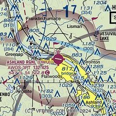
| Sectional chart |
|---|
|
CAUTION: Diagram may not be current

| Airport distance calculator |
|---|
|
|
| Sunrise and sunset |
|---|
|
Times for 20-Aug-2025
| | Local
(UTC-4) | | Zulu
(UTC) |
|---|
| Morning civil twilight | | 06:23 | | 10:23 |
| Sunrise | | 06:51 | | 10:51 |
| Sunset | | 20:18 | | 00:18 |
| Evening civil twilight | | 20:46 | | 00:46 |
|
| Current date and time |
|---|
| Zulu (UTC) | 20-Aug-2025 08:29:07 |
|---|
| Local (UTC-4) | 20-Aug-2025 04:29:07 |
|---|
|
| METAR |
|---|
| KDWU | 200756Z AUTO 00000KT 10SM FEW070 BKN110 23/ A2993 RMK AO2 SLP131 T0233
|
KHTS
14nm SE | 200751Z 00000KT 10SM FEW065 SCT080 SCT100 24/22 A2994 RMK AO2 SLP127 T02390217 $
|
KPMH
18nm N | 200804Z 33002KT 10SM CLR 22/22 A2993 RMK AO2
|
|
| TAF |
|---|
KHTS
14nm SE | 200521Z 2006/2106 00000KT P6SM VCSH SCT050 BKN100 TEMPO 2006/2008 5SM -SHRA FM201200 00000KT P6SM SCT020 BKN080 FM201400 00000KT P6SM VCSH BKN020 FM201700 VRB03KT P6SM BKN030 FM202000 34005KT P6SM SCT030 FM210100 35005KT P6SM FEW100
|
|
| NOTAMs |
|---|
NOTAMs are issued by the DoD/FAA and will open in a separate window not controlled by AirNav.
|
|


