FAA INFORMATION EFFECTIVE 09 JULY 2026
Location
| FAA Identifier: | EDC |
| Lat/Long: | 30-23-50.9753N 097-33-59.0166W
30-23.849588N 097-33.983610W
30.3974931,-97.5663935
(estimated) |
| Elevation: | 620 ft. / 189.0 m (surveyed) |
| Variation: | 05E (2010) |
| From city: | 12 miles NE of AUSTIN, TX |
| Time zone: | UTC -5 (UTC -6 during Standard Time) |
| Zip code: | 78660 |
Airport Operations
| Airport use: | Open to the public |
| Activation date: | 01/1966 |
| Control tower: | yes |
| ARTCC: | HOUSTON CENTER |
| FSS: | SAN ANGELO FLIGHT SERVICE STATION |
| NOTAMs facility: | EDC (NOTAM-D service available) |
| Attendance: | CONTINUOUS |
| Wind indicator: | lighted |
| Segmented circle: | yes |
| Lights: | ACTVT REIL RWYS 13 & 31; MIRL RWY 13/31 - CTAF. |
| Beacon: | white-green (lighted land airport)
Operates sunset to sunrise. |
Airport Communications
| CTAF: | 120.3 |
| UNICOM: | 122.975 |
| WX AWOS-3: | 118.825 (512-616-2967) |
| EXECUTIVE TOWER GROUND: | 119.45 [0700-2200] |
| EXECUTIVE TOWER TOWER: | 120.3 [0700-2200] |
| AUSTIN APPROACH: | 127.225 |
| AUSTIN DEPARTURE: | 127.225 |
| CLEARANCE DELIVERY: | 126.025 ;WHEN EDC TWR CLSD |
| AEROZ DP: | 127.225 |
| BNDIA DP: | 127.225 |
| ELOEL DP: | 127.225 |
| ILEXY DP: | 127.225 |
| MUCKY DP: | 127.225 |
| POTRR STAR: | 127.225 |
| SAYBR DP: | 127.225 |
| WX AWOS-3PT at T74 (12 nm NE): | 119.75 (512-352-4995) |
| WX ASOS at AUS (13 nm SW): | PHONE 512-369-7881 |
| WX AWOS-3PT at GTU (18 nm N): | PHONE 512-869-3430 |
Nearby radio navigation aids
| VOR radial/distance | | VOR name | | Freq | | Var |
|---|
| CWKr295/2.2 | | CENTEX VORTAC | | 112.80 | | 06E |
Airport Services
| Fuel available: | 100LL JET-A+ |
| Parking: | hangars and tiedowns |
| Airframe service: | MAJOR |
| Powerplant service: | MAJOR |
Runway Information
Runway 13/31
| Dimensions: | 6025 x 100 ft. / 1836 x 30 m |
| Surface: | asphalt, in good condition |
| Weight bearing capacity: | |
| Runway edge lights: | medium intensity |
| RUNWAY 13 | | RUNWAY 31 |
| Latitude: | 30-24.216333N | | 30-23.558667N |
| Longitude: | 097-34.407500W | | 097-33.547667W |
| Elevation: | 620.0 ft. | | 596.6 ft. |
| Traffic pattern: | left | | left |
| Displaced threshold: | 600 ft. | | no |
| Markings: | nonprecision, in fair condition | | nonprecision, in fair condition |
| Visual slope indicator: | 4-light PAPI on left (3.00 degrees glide path) | | 4-light PAPI on left (3.00 degrees glide path) |
| Runway end identifier lights: | yes | | yes |
| Touchdown point: | yes, no lights | | yes, no lights |
| Obstructions: | 58 ft. tree, 900 ft. from runway, 400 ft. right of centerline, 12:1 slope to clear
APCH SLOPE 23:1 TO DSPLCD THR. | | none |
Runway 16/34
| Dimensions: | 1550 x 25 ft. / 472 x 8 m |
| Surface: | asphalt/L
EXTSV CRACKING, VEGETATION GROWING THROUGH. |
| Weight bearing capacity: | |
| Operational restrictions: | CLSD INDEFLY. |
| RUNWAY 16 | | RUNWAY 34 |
| Latitude: | 30-23.826333N | | 30-23.578103N |
| Longitude: | 097-34.042667W | | 097-33.971413W |
| Elevation: | 615.0 ft. | | 599.3 ft. |
| Traffic pattern: | left | | left |
| Runway heading: | 161 magnetic, 166 true | | 341 magnetic, 346 true |
| Markings: | , in poor condition | | , in poor condition |
| Touchdown point: | yes, no lights | | yes, no lights |
Airport Ownership and Management from official FAA records
| Ownership: | Privately-owned |
| Owner: | TRAVIS COUNTY FIELD LLC
2916 CARDIFF ROAD
BROOKSHIRE, TX 77423
Phone 512-247-7678 |
| Manager: | REED BRICKEY
6012 AVIATION DR
PFLUGERVILLE, TX 78660
Phone 713-679-4308
RBRICKEY@AUSTINEXECUTIVEAIRPORT.COM |
Additional Remarks
| A58-34 | 10 TREE, 100 FT DSTC, 50 FT R. |
| - | VFR DEPS REQUESTING ATC SVC REMAIN CLEAR OF THE FINAL APCH CRS OF KAUS RWYS 18L & 18R. IF THE ACFT IS INITIALLY EASTBOUND, CTC AUS APCH CTL ON 127.22. IF THE ACFT IS INITIALLY WESTBOUND CTC AUS APCH CTL ON 125.32. AUS CLEAREANCE DELIVERY 126.025. |
| - | RWY 13/31 TWY EDGES ARE MKD BY REFLECTOR POSTS. |
| - | NW END OF RWY 13/31 & TWY A HAS A 16 FT DROP OFF AT END OF PAVEMENT. |
| - | FOR CD CTC AUSTIN APCH AT 512-369-7865. |
Instrument Procedures
NOTE: All procedures below are presented as PDF files. If you need a reader for these files, you should download the free Adobe Reader.NOT FOR NAVIGATION. Please procure official charts for flight.
FAA instrument procedures published for use from 09 July 2026 at 0901Z to 06 August 2026 at 0900Z.
STARs - Standard Terminal Arrivals |
|---|
| BLEWE FIVE **NEW** | |
download (157KB) |
| POTRR TWO (RNAV) **NEW** | |
download (166KB) |
| SZAGI THREE (RNAV) **NEW** | |
download (196KB) |
IAPs - Instrument Approach Procedures |
|---|
| RNAV (GPS) RWY 13 **CHANGED** | |
download (228KB) |
| RNAV (GPS) RWY 31 **CHANGED** | |
download (222KB) |
| NOTE: Special Alternate Minimums apply | |
download (123KB) |
Departure Procedures |
|---|
| AEROZ TWO (RNAV) | |
download (158KB) |
| BNDIA THREE (RNAV) | |
download (148KB) |
| ELOEL THREE (RNAV) | |
download (172KB) |
| ILEXY FOUR (RNAV) | |
download (189KB) |
| MUCKY THREE (RNAV) | |
download (146KB) |
| SAYBR THREE (RNAV) | |
download (156KB) |
| NOTE: Special Take-Off Minimums/Departure Procedures apply | |
download (303KB) |
Other nearby airports with instrument procedures:
T74 - Taylor Municipal Airport (12 nm NE)
KAUS - Austin-Bergstrom International Airport (13 nm SW)
KGTU - Georgetown Executive Airport (18 nm N)
KRYW - Lago Vista TX/Rusty Allen Airport (22 nm W)
3R9 - Lakeway Airpark (22 nm W)
|
|

Road maps at:
MapQuest
Bing
Google
| Aerial photo |
|---|
WARNING: Photo may not be current or correct
 Photo by Ross Nyerges
Photo taken 09-May-2019
looking east.
Photo by Ross Nyerges
Photo taken 09-May-2019
looking east.
Do you have a better or more recent aerial photo of Austin Executive Airport that you would like to share? If so, please send us your photo.
|
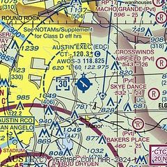
| Sectional chart |
|---|
|
CAUTION: Diagram may not be current

| Airport distance calculator |
|---|
|
|
| Sunrise and sunset |
|---|
|
Times for 02-Aug-2026
| | Local
(UTC-5) | | Zulu
(UTC) |
|---|
| Morning civil twilight | | 06:24 | | 11:24 |
| Sunrise | | 06:50 | | 11:50 |
| Sunset | | 20:23 | | 01:23 |
| Evening civil twilight | | 20:49 | | 01:49 |
|
| Current date and time |
|---|
| Zulu (UTC) | 03-Aug-2026 01:54:10 |
|---|
| Local (UTC-5) | 02-Aug-2026 20:54:10 |
|---|
|
| METAR |
|---|
| KEDC | 030135Z AUTO 09006KT 10SM CLR 31/14 A2984 RMK AO2 T03080135 $
|
KATT
9nm SW | 030051Z AUTO 00000KT 10SM CLR 34/13 A2982 RMK AO2 SLP084 T03390128 $
|
KAUS
10nm SW | 030053Z 08008KT 10SM FEW110 FEW300 34/13 A2980 RMK AO2 SLP079 T03440133 $
|
KT74
12nm NE | 030135Z AUTO 08005KT 10SM CLR 32/14 A2988 RMK AO2
|
KGTU
17nm N | 030055Z 06005KT 10SM CLR 34/14 A2985 RMK AO2 SLP098 T03440139
|
|
| TAF |
|---|
KAUS
10nm SW | 022053Z 0221/0324 05003KT P6SM FEW080 FM030700 22004KT P6SM SKC FM031800 18006KT P6SM SKC
|
|
| NOTAMs |
|---|
NOTAMs are issued by the DoD/FAA and will open in a separate window not controlled by AirNav.
|
|


