FAA INFORMATION EFFECTIVE 07 AUGUST 2025
Location
| FAA Identifier: | ELY |
| Lat/Long: | 39-17-58.8780N 114-50-30.7610W
39-17.981300N 114-50.512683W
39.2996883,-114.8418781
(estimated) |
| Elevation: | 6259.7 ft. / 1908.0 m (surveyed) |
| Variation: | 14E (2005) |
| From city: | 3 miles NE of ELY, NV |
| Time zone: | UTC -7 (UTC -8 during Standard Time) |
| Zip code: | 89301 |
Airport Operations
| Airport use: | Open to the public |
| Activation date: | 11/1938 |
| Control tower: | no |
| ARTCC: | SALT LAKE CITY CENTER |
| FSS: | RENO FLIGHT SERVICE STATION |
| NOTAMs facility: | ELY (NOTAM-D service available) |
| Attendance: | MON-SAT 0800-1700 |
| Wind indicator: | lighted |
| Segmented circle: | yes |
| Lights: | ACTVT REIL RWY 18 & 36; PAPI RWY 12, 18 & 36; HIRL RWY 18/36; MIRL RWY 12/30 - CTAF. |
| Beacon: | white-green (lighted land airport)
Operates sunset to sunrise. |
Airport Communications
| CTAF/UNICOM: | 122.8 |
| WX ASOS: | 120.625 (775-289-4466) |
- APCH/DEP CTL SVC PRVDD BY SALT LAKE ARTCC ( ZLC) ON FREQ 133.45/317.625 (ELY RCAG).
Nearby radio navigation aids
| VOR radial/distance | | VOR name | | Freq | | Var |
|---|
| ELY at field | | ELY VOR/DME | | 113.95 | | 14E |
Airport Services
| Fuel available: | 100LL JET-A
100LL:FUEL AVBL AFT HRS. |
| Parking: | hangars and tiedowns |
| Airframe service: | NONE |
| Powerplant service: | NONE |
| Bottled oxygen: | HIGH |
| Bulk oxygen: | NONE |
Runway Information
Runway 18/36
| Dimensions: | 6017 x 150 ft. / 1834 x 46 m |
| Surface: | asphalt/grooved, in excellent condition |
| Weight bearing capacity: | | Single wheel: | 70.0 | | Double wheel: | 85.0 | | Double tandem: | 130.0 |
|
| Runway edge lights: | high intensity |
| RUNWAY 18 | | RUNWAY 36 |
| Latitude: | 39-18.529180N | | 39-17.566832N |
| Longitude: | 114-50.138678W | | 114-50.442365W |
| Elevation: | 6225.1 ft. | | 6259.7 ft. |
| Traffic pattern: | left | | left |
| Runway heading: | 180 magnetic, 194 true | | 000 magnetic, 014 true |
| Markings: | nonprecision, in good condition | | nonprecision, in good condition |
| Visual slope indicator: | 4-light PAPI on left (3.00 degrees glide path) | | 4-light PAPI on left (3.00 degrees glide path) |
| Runway end identifier lights: | yes | | yes |
| Touchdown point: | yes, no lights | | yes, no lights |
Runway 12/30
| Dimensions: | 4825 x 60 ft. / 1471 x 18 m |
| Surface: | asphalt, in good condition |
| Weight bearing capacity: | |
| Runway edge lights: | medium intensity |
| RUNWAY 12 | | RUNWAY 30 |
| Latitude: | 39-18.205232N | | 39-17.590973N |
| Longitude: | 114-51.114037W | | 114-50.465437W |
| Elevation: | 6239.5 ft. | | 6259.0 ft. |
| Traffic pattern: | left | | left |
| Runway heading: | 127 magnetic, 141 true | | 307 magnetic, 321 true |
| Markings: | nonprecision, in good condition | | numbers only, in good condition |
| Visual slope indicator: | 4-light PAPI on right (3.00 degrees glide path) | | |
| Runway end identifier lights: | no | | no |
| Touchdown point: | yes, no lights | | yes, no lights |
| Obstructions: | none | | 30 ft. pole, 1230 ft. from runway, 10 ft. right of centerline, 20:1 slope to clear |
Airport Ownership and Management from official FAA records
| Ownership: | Publicly-owned |
| Owner: | WHITE PINE COUNTY
801 CLARK ST.
ELY, NV 89301
Phone 775-293-6509 |
| Manager: | BILL CALDERWOOD
1472 MCGILL HIGHWAY
ELY, NV 89315-0437
Phone 775-293-7161
FBO 775-289-8804 CLOSED SUNDAYS; CALL-OUT FEE. |
Additional Remarks
| - | ULTRA-LIGHT ACFT OPS ON AND INVOF ARPT DRG DALGT HRS. |
| - | RWY 12/30 NOT AVBL FOR ACFT OVR 30 PAX SEATS. |
| - | GLD OPS ON AND INVOF ARPT MAY-SEPT. |
| - | FOR CD IF UNA TO CTC ON FSS FREQ, CTC SALT LAKE ARTCC AT 801-320-2568. |
Instrument Procedures
NOTE: All procedures below are presented as PDF files. If you need a reader for these files, you should download the free Adobe Reader.NOT FOR NAVIGATION. Please procure official charts for flight.
FAA instrument procedures published for use from 07 August 2025 at 0901Z to 04 September 2025 at 0900z.
IAPs - Instrument Approach Procedures |
|---|
| RNAV (GPS) RWY 18 **CHANGED** | |
download (406KB) |
| VOR-C **CHANGED** | |
download (427KB) |
| NOTE: Special Alternate Minimums apply **CHANGED** | |
download (143KB) |
|
|---|
| ELY TWO (OBSTACLE) | |
2 pages:
[1] [2] (533KB) |
| NOTE: Special Take-Off Minimums/Departure Procedures apply | |
download (348KB) |
Other nearby airports with instrument procedures:
05U - Eureka Airport (57 nm W)
KENV - Wendover Airport (93 nm NE)
|
|

Road maps at:
MapQuest
Bing
Google
| Aerial photo |
|---|
WARNING: Photo may not be current or correct
 Photo by RV8 Pilot
Photo taken 08-Dec-2018
looking northwest.
Photo by RV8 Pilot
Photo taken 08-Dec-2018
looking northwest.
Do you have a better or more recent aerial photo of Ely Airport/Yelland Field that you would like to share? If so, please send us your photo.
|
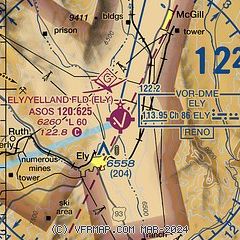
| Sectional chart |
|---|
|
| Airport distance calculator |
|---|
|
|
| Sunrise and sunset |
|---|
|
Times for 03-Sep-2025
| | Local
(UTC-7) | | Zulu
(UTC) |
|---|
| Morning civil twilight | | 05:43 | | 12:43 |
| Sunrise | | 06:11 | | 13:11 |
| Sunset | | 19:07 | | 02:07 |
| Evening civil twilight | | 19:34 | | 02:34 |
|
| Current date and time |
|---|
| Zulu (UTC) | 04-Sep-2025 03:23:07 |
|---|
| Local (UTC-7) | 03-Sep-2025 20:23:07 |
|---|
|
| METAR |
|---|
| KELY | 040253Z AUTO 27009KT 10SM FEW070 BKN085 OVC110 17/08 A3027 RMK AO2 SLP164 T01720078 58004 TSNO
|
|
| TAF |
|---|
| KELY | 031720Z 0318/0418 17008KT P6SM SCT120 FM031900 VRB06G16KT P6SM VCTS BKN090CB FM040200 19008KT P6SM SCT070 BKN100 FM041700 27008KT P6SM VCTS SCT060 BKN090CB
|
|
| NOTAMs |
|---|
NOTAMs are issued by the DoD/FAA and will open in a separate window not controlled by AirNav.
|
|

