FAA INFORMATION EFFECTIVE 27 NOVEMBER 2025
Location
| FAA Identifier: | FFM |
| Lat/Long: | 46-17-03.8220N 096-09-24.0750W
46-17.063700N 096-09.401250W
46.2843950,-96.1566875
(estimated) |
| Elevation: | 1182.4 ft. / 360.4 m (surveyed) |
| Variation: | 05E (1995) |
| From city: | 3 miles W of FERGUS FALLS, MN |
| Time zone: | UTC -6 (UTC -5 during Daylight Saving Time) |
| Zip code: | 56537 |
Airport Operations
| Airport use: | Open to the public |
| Activation date: | 10/1942 |
| Control tower: | no |
| ARTCC: | MINNEAPOLIS CENTER |
| FSS: | PRINCETON FLIGHT SERVICE STATION |
| NOTAMs facility: | FFM (NOTAM-D service available) |
| Attendance: | MON-FRI 0800-1700, ALL SAT 0900-1400
FOR ATTENDANT AFT HRS CALL AMGR. |
| Wind indicator: | lighted |
| Segmented circle: | no |
| Lights: | ACTVT MALSR RWY 31; REIL RWY 13 & 35; PAPI RWY 13 & 31; MIRL RWY 13/31 & 17/35 - CTAF. |
| Beacon: | white-green (lighted land airport)
Operates sunset to sunrise. |
Airport Communications
| CTAF/UNICOM: | 122.8 |
| WX AWOS-3PT: | 119.05 (218-736-7216) |
| WX AWOS-3 at BWP (19 nm W): | 127.875 (701-642-9800) |
| WX AWOS-3 at Y63 (19 nm S): | 118.075 (218-685-6456) |
- APCH/DEP SVC PRVDD BY MINNEAPOLIS ARTCC ON FREQ 126.1/269.2 (ALEXANDRIA RCAG).
- COMMUNICATIONS PRVDD BY PRINCETON RADIO ON FREQ 122.6 (FERGUS FALLS RCO).
Nearby radio navigation aids
| VOR radial/distance | | VOR name | | Freq | | Var |
|---|
| FFM at field | | FERGUS FALLS VOR/DME | | 110.40 | | 05E |
| DTLr197/34.3 | | DETROIT LAKES VOR/DME | | 111.20 | | 02E |
| NDB name | | Hdg/Dist | | Freq | | Var | | ID |
|---|
| HAMRE | | 308/5.6 | | 337 | | 05E | | FF | ..-. ..-. |
Airport Services
| Fuel available: | 100LL JET-A
100LL:FUEL AVBL H24 VIA CREDIT CARD. |
| Parking: | hangars and tiedowns |
| Airframe service: | MINOR |
| Powerplant service: | MINOR |
| Bottled oxygen: | NONE |
| Bulk oxygen: | NONE |
Runway Information
Runway 13/31
| Dimensions: | 5639 x 100 ft. / 1719 x 30 m |
| Surface: | asphalt, in good condition |
| Weight bearing capacity: | | Single wheel: | 60.0 | | Double wheel: | 90.0 |
|
| Runway edge lights: | medium intensity |
| RUNWAY 13 | | RUNWAY 31 |
| Latitude: | 46-17.357220N | | 46-16.722138N |
| Longitude: | 096-09.735963W | | 096-08.760680W |
| Elevation: | 1181.7 ft. | | 1175.6 ft. |
| Traffic pattern: | left | | left |
| Runway heading: | 128 magnetic, 133 true | | 308 magnetic, 313 true |
| Markings: | precision, in fair condition | | precision, in fair condition |
| Visual slope indicator: | 4-light PAPI on left (3.00 degrees glide path) | | 4-light PAPI on left (3.00 degrees glide path) |
| Approach lights: | | | MALSR: 1,400 foot medium intensity approach lighting system with runway alignment indicator lights |
| Runway end identifier lights: | yes | | |
| Touchdown point: | yes, no lights | | yes, no lights |
| Instrument approach: | | | ILS |
Runway 17/35
| Dimensions: | 3299 x 75 ft. / 1006 x 23 m |
| Surface: | asphalt, in fair condition |
| Weight bearing capacity: | | Single wheel: | 16.0 | | Double wheel: | 22.0 |
|
| Runway edge lights: | medium intensity |
| RUNWAY 17 | | RUNWAY 35 |
| Latitude: | 46-17.376030N | | 46-16.833468N |
| Longitude: | 096-09.667915W | | 096-09.657612W |
| Elevation: | 1182.2 ft. | | 1157.7 ft. |
| Traffic pattern: | left | | left |
| Runway heading: | 174 magnetic, 179 true | | 354 magnetic, 359 true |
| Markings: | nonprecision, in fair condition | | nonprecision, in fair condition |
| Runway end identifier lights: | no | | yes |
| Touchdown point: | yes, no lights | | yes, no lights |
Airport Ownership and Management from official FAA records
| Ownership: | Publicly-owned |
| Owner: | CITY OF FERGUS FALLS
112 W WASHINGTON AVE, PO BOX 868
FERGUS FALLS, MN 56537-2568
Phone 218-332-5435 |
| Manager: | SKY CREW SERVICES
4005 STATE HIGHWAY 210 W
FERGUS FALLS, MN 56537-4005
Phone 218-739-3733 |
Additional Remarks
| - | DEER & WATERFOWL ON & INVOF ARPT. |
| - | ULTRALIGHTS ON & INVOF ARPT. ULTRALIGHT PATTERN 1800 FT MSL. |
| - | FOR CD IF UNA TO CTC ON FSS FREQ, CTC MINNEAPOLIS ARTCC AT 651-463-5588. |
Instrument Procedures
NOTE: All procedures below are presented as PDF files. If you need a reader for these files, you should download the free Adobe Reader.NOT FOR NAVIGATION. Please procure official charts for flight.
FAA instrument procedures published for use from 27 November 2025 at 0901Z to 25 December 2025 at 0900Z.
IAPs - Instrument Approach Procedures |
|---|
| ILS OR LOC RWY 31 | |
download (282KB) |
| RNAV (GPS) RWY 13 | |
download (279KB) |
| RNAV (GPS) RWY 31 | |
download (289KB) |
| RNAV (GPS) RWY 35 | |
download (224KB) |
| VOR RWY 13 | |
download (233KB) |
| NOTE: Special Alternate Minimums apply | |
download (175KB) |
| NOTE: Special Take-Off Minimums/Departure Procedures apply | |
download (405KB) |
Other nearby airports with instrument procedures:
KBWP - Harry Stern Airport (19 nm W)
Y63 - Elbow Lake Municipal/Pride of the Prairie Airport (19 nm S)
16D - Perham Municipal Airport (30 nm NE)
KDTL - Detroit Lakes Airport-Wething Field (34 nm N)
KETH - Wheaton Municipal Airport (34 nm SW)
|
|

Road maps at:
MapQuest
Bing
Google
| Aerial photo |
|---|
WARNING: Photo may not be current or correct
 Photo taken 11-Aug-2007
from the southeast looking northwest to the airport with 13-31 in the foreground, 17-35 in the background
Photo taken 11-Aug-2007
from the southeast looking northwest to the airport with 13-31 in the foreground, 17-35 in the background
Do you have a better or more recent aerial photo of Fergus Falls Municipal Airport-Einar Mickelson Field that you would like to share? If so, please send us your photo.
|
| Sectional chart |
|---|
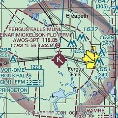
|
| Airport distance calculator |
|---|
|
|
| Sunrise and sunset |
|---|
|
Times for 09-Dec-2025
| | Local
(UTC-6) | | Zulu
(UTC) |
|---|
| Morning civil twilight | | 07:22 | | 13:22 |
| Sunrise | | 07:57 | | 13:57 |
| Sunset | | 16:37 | | 22:37 |
| Evening civil twilight | | 17:12 | | 23:12 |
|
| Current date and time |
|---|
| Zulu (UTC) | 09-Dec-2025 07:16:13 |
|---|
| Local (UTC-6) | 09-Dec-2025 01:16:13 |
|---|
|
| METAR |
|---|
| KFFM | 090655Z AUTO 32018KT 7SM OVC006 M05/M06 A2973 RMK AO2 TSNO
|
KBWP
19nm W | 090655Z AUTO 33014KT 8SM OVC010 M05/M05 A2975 RMK AO2
|
KY63
19nm S | 090655Z AUTO 32013KT 7SM OVC006 M04/M05 A2973 RMK AO2 T10401051
|
|
| TAF |
|---|
KAXN
40nm SE | 090520Z 0906/1006 26010KT 6SM BR OVC006 FM090800 29011KT 6SM BR OVC006 FM091700 18012KT 2SM -SN OVC005 FM092000 20011G17KT 1/2SM SN OVC004 FM100100 34016G26KT 1 1/2SM -SN BR OVC007
|
KFAR
47nm NW | 090526Z 0906/1006 32015G22KT P6SM BKN015 FM090800 VRB05KT P6SM SCT015 FM091700 16012G21KT 2SM -FZRASN OVC008 FM092100 22019G33KT 1 1/2SM -SN BLSN OVC006 WS020/26035KT FM092300 27028G48KT 1/2SM SN BLSN OVC005 WS020/24035KT FM100200 31022G39KT 1SM -SN BLSN OVC007
|
|
| NOTAMs |
|---|
NOTAMs are issued by the DoD/FAA and will open in a separate window not controlled by AirNav.
|
|

