FAA INFORMATION EFFECTIVE 09 JULY 2026
Location
| FAA Identifier: | FMH |
| Lat/Long: | 41-39-32.9000N 070-31-22.1000W
41-39.548333N 070-31.368333W
41.6591389,-70.5228056
(estimated) |
| Elevation: | 130.2 ft. / 39.7 m (surveyed) |
| Variation: | 15W (1980) |
| Time zone: | UTC -4 (UTC -5 during Standard Time) |
| Zip code: | 02542 |
Airport Operations
| Airport use: | Private use. Permission required prior to landing |
| Activation date: | 03/1941 |
| Control tower: | yes |
| ARTCC: | BOSTON CENTER |
| FSS: | BRIDGEPORT FLIGHT SERVICE STATION |
| NOTAMs facility: | FMH (NOTAM-D service available) |
| Attendance: | CONTINUOUS |
| Pattern altitude: | 1100.2 ft. MSL
ROTARY WING 970 FT AGL; FIXED WING CONVL 1470 FT AGL; JET OVHD 1970 FT AGL. |
| Wind indicator: | yes |
| Segmented circle: | no |
| Beacon: | white-green (lighted land airport)
CLEAR SIDE IS SPLIT LIGHT..76... TURNED ON DAYLGT HRS WHEN A/D IS UNDER IFR CONDITIONS. APT BCN PARTIALLY OBSCURED N THRU E ALL ALTS. |
Airport Communications
| ATIS: | 120.475 236.825 |
| WX ASOS: | PHONE 508-968-6562 |
| COAST GUARD GROUND: | 124.15 275.8 |
| COAST GUARD TOWER: | 128.425 291.1 |
| BOSTON APPROACH: | 118.2 |
| BOSTON DEPARTURE: | 118.2 |
| ARMY OPS: | 122.85 |
| ARNG OPS: | 138.5 341.675 46.85 |
| CG OPS: | 381.8X ;CAPE COD AIR |
| EMERG: | 121.5 243.0 |
| WX ASOS at HYA (11 nm E): | PHONE 508-862-2601 |
| WX ASOS at MVY (16 nm S): | 126.25 (508-696-6988) |
| WX ASOS at PYM (18 nm NW): | 135.625 (508-319-1421) |
| WX ASOS at EWB (20 nm W): | 126.85 (508-992-0195) |
Nearby radio navigation aids
| VOR radial/distance | | VOR name | | Freq | | Var |
|---|
| MVYr029/16.3 | | MARTHAS VINEYARD VOR/DME | | 114.50 | | 15W |
| LFVr241/30.5 | | MARCONI VOR/DME | | 114.70 | | 16W |
| ACKr330/31.8 | | NANTUCKET VOR/DME | | 116.20 | | 15W |
| NDB name | | Hdg/Dist | | Freq | | Var | | ID |
|---|
| NAUSET | | 281/24.1 | | 279 | | 16W | | CQX | -.-. --.- -..- |
| PROVINCETOWN | | 225/28.0 | | 389 | | 16W | | PVC | .--. ...- -.-. |
Airport Services
| Fuel available: | J5 |
| Parking: | hangars |
| Airframe service: | NONE |
| Powerplant service: | NONE |
| Bottled oxygen: | NONE |
| Bulk oxygen: | LOW |
Runway Information
Runway 14/32
| Dimensions: | 9501 x 150 ft. / 2896 x 46 m |
| Surface: | asphalt/concrete
FIRST 2800 FT RWY 14 & FIRST 500 FT RWY 32 CONC; MID PORTION ASPH. |
| Weight bearing capacity: | |
| Runway edge lights: | high intensity |
| RUNWAY 14 | | RUNWAY 32 |
| Latitude: | 41-40.046437N | | 41-39.095678N |
| Longitude: | 070-32.296803W | | 070-30.640153W |
| Elevation: | 130.2 ft. | | 110.4 ft. |
| Traffic pattern: | left | | left |
| Runway heading: | 142 magnetic, 127 true | | 322 magnetic, 307 true |
| Markings: | precision, in good condition | | precision, in good condition |
| Visual slope indicator: | 4-light PAPI on left (3.00 degrees glide path) | | 4-light PAPI on left (3.00 degrees glide path) |
| RVR equipment: | rollout | | touchdown |
| Approach lights: | | | MALSR: 1,400 foot medium intensity approach lighting system with runway alignment indicator lights |
| Runway end identifier lights: | yes | | no |
| Touchdown point: | yes, no lights | | yes, no lights |
| Instrument approach: | | | ILS/DME |
Runway 5/23
| Dimensions: | 8000 x 150 ft. / 2438 x 46 m |
| Surface: | asphalt/concrete
FIRST 350 FT RWY 05 CONC; REMAINING 7650 FT ASPH. |
| Weight bearing capacity: | |
| Runway edge lights: | high intensity |
| RUNWAY 5 | | RUNWAY 23 |
| Latitude: | 41-39.008235N | | 41-40.032850N |
| Longitude: | 070-31.801988W | | 070-30.698145W |
| Elevation: | 110.5 ft. | | 125.5 ft. |
| Traffic pattern: | left | | left |
| Runway heading: | 054 magnetic, 039 true | | 234 magnetic, 219 true |
| Markings: | precision, in good condition | | precision, in good condition |
| Visual slope indicator: | 4-light PAPI on left (3.00 degrees glide path) | | 4-light PAPI on left (3.00 degrees glide path) |
| RVR equipment: | rollout | | touchdown |
| Approach lights: | | | MALSR: 1,400 foot medium intensity approach lighting system with runway alignment indicator lights |
| Runway end identifier lights: | yes | | no |
| Touchdown point: | yes, no lights | | yes, no lights |
| Instrument approach: | | | ILS/DME |
Airport Ownership and Management from official FAA records
| Ownership: | Unknown (CG) |
| Owner: | US COAST GUARD
3172 HERBERT RD
BUZZARDS BAY, MA 02542 |
| Manager: | TONY HYLINSKI
3172 HERBERT RD, BUILDING 3172
BUZZARDS BAY, MA 02542
Phone 508-968-6674
ALTN FONE 508-968-6673. ANTHONY.P.HYLINSKI@USCG.MIL. |
Additional Remarks
| - | RSTD: ANG RAMP UNUSBL. NO PPR FOR MIL/LAW ENFORCEMENT/MED FLT. CTC ARPT MGMT C508-968-6674 24 HR PRIOR IF PRKG/RON (EXCLD ACTIVE MEDEVAC). NO CIV LDG WO PPR FM ARPT MGMT. NO TSNT SVC INCL FUEL. |
| - | ARNG: PPR FOR ARNG RAMP, LTD FUEL AVBL: CTC OPS C339-202-9533. OPR 1200-2200Z++ MON-FRI, LTD SVC AVBL SAT-SUN WITH PRIOR COORDN. CTC BOSOX OPS 10 MIN PRIOR TO ARR ON 341.675, 138.5, 46.85. FLT BRIEFING RQRD PRIOR TO OPS IN R-4101. CTC OSA F/W DET C339-202-9629/9533 TO COORD JOSAC PAX ARR/DEP. |
| - | USCG: PPR FOR USCG RAMP, LTD SVC AVBL WITH PRIOR COORDN C508-968-6360/6361, DSN 557-6360/6361 OR C800-673-1056. ARR ACFT CTC USCG OPS (CAPEAIR) 345.0, 122.975 OR 164.55 15 MIN PRIOR TO ARR. |
| - | BRG STRENGTH RWY 05-23 & 14-32: ST175. |
| - | SEE FLIP AP/1 SUPPLEMENTARY ARPT RMK & AP/1A. |
| - | MISC: PPR IF ACN EXCEEDS PUBLD PCN. CTC ARPT MGMT C508-968-6674/6673 FOR APVL. |
| - | TGL OPS FOR ACFT OVR 200000 LBS PROHIBITED. |
| - | NS ABTMT - OFFL BUS 0300-1200Z++. |
| - | CAUTION: EXTSV BIRD ACT ALL QUADS. CK ATIS FOR UAS ACT IN CLASS D ASP. NON-STD OBST LGTD 368 FT TWRS 4 NM NNE OF ARPT. |
| - | NON-STD OBSTN LGTD 368 FT TWRS NE OF ARPT. |
Instrument Procedures
NOTE: All procedures below are presented as PDF files. If you need a reader for these files, you should download the free Adobe Reader.NOT FOR NAVIGATION. Please procure official charts for flight.
FAA instrument procedures published for use from 09 July 2026 at 0901Z to 06 August 2026 at 0900Z.
IAPs - Instrument Approach Procedures |
|---|
| ILS Z OR LOC Z RWY 23 **CHANGED** | |
download (316KB) |
| ILS Z OR LOC Z RWY 32 **CHANGED** | |
download (283KB) |
| RNAV (GPS) RWY 05 **CHANGED** | |
download (266KB) |
| RNAV (GPS) RWY 14 **CHANGED** | |
download (271KB) |
| RNAV (GPS) RWY 23 **CHANGED** | |
download (291KB) |
| RNAV (GPS) RWY 32 **CHANGED** | |
download (285KB) |
| COPTER ILS Y OR LOC Y RWY 23 **CHANGED** | |
download (306KB) |
| COPTER ILS Y OR LOC Y RWY 32 **CHANGED** | |
download (290KB) |
| NOTE: Special Alternate Minimums apply **CHANGED** | |
download (149KB) |
| NOTE: Special Take-Off Minimums/Departure Procedures apply | |
download (428KB) |
Other nearby airports with instrument procedures:
5B6 - Falmouth Airpark (4 nm S)
KHYA - Cape Cod Gateway Airport (11 nm E)
KMVY - Martha's Vineyard Airport (16 nm S)
KPYM - Plymouth Municipal Airport (18 nm NW)
KEWB - New Bedford Regional Airport (20 nm W)
|
|

Road maps at:
MapQuest
Bing
Google
| Aerial photo |
|---|
WARNING: Photo may not be current or correct
 Photo courtesy of AirNav, LLC
Photo taken 24-Aug-2012
looking north.
Photo courtesy of AirNav, LLC
Photo taken 24-Aug-2012
looking north.
Do you have a better or more recent aerial photo of Cape Cod Coast Guard Air Station that you would like to share? If so, please send us your photo.
|
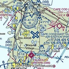
| Sectional chart |
|---|
|
 Download PDF
of official airport diagram from the FAA
| Airport distance calculator |
|---|
|
|
| Sunrise and sunset |
|---|
|
Times for 02-Aug-2026
| | Local
(UTC-4) | | Zulu
(UTC) |
|---|
| Morning civil twilight | | 05:07 | | 09:07 |
| Sunrise | | 05:38 | | 09:38 |
| Sunset | | 19:58 | | 23:58 |
| Evening civil twilight | | 20:30 | | 00:30 |
|
| Current date and time |
|---|
| Zulu (UTC) | 03-Aug-2026 02:08:44 |
|---|
| Local (UTC-4) | 02-Aug-2026 22:08:44 |
|---|
|
| METAR |
|---|
KFMH
2nm S | 030156Z 16009KT 10SM OVC005 24/23 A2994
|
KHYA
11nm E | 030156Z 12006KT 10SM OVC005 23/22 A2991 RMK AO2 SLP130 T02280217
|
KMVY
16nm S | 030153Z 15009KT 9SM BKN008 BKN016 OVC039 22/22 A2992 RMK AO2 SLP131 T02220217
|
KPYM
18nm NW | 030152Z AUTO VRB03KT 10SM OVC008 23/22 A2991 RMK AO2 CIG 006V011 SLP130 T02280222 $
|
KEWB
19nm W | 030153Z 17006KT 10SM OVC005 23/23 A2990 RMK AO2 RAE02 SLP126 P0000 T02330228
|
|
| TAF |
|---|
KFMH
2nm S | 021746Z 0218/0318 20008KT P6SM SCT015 BKN120 FM030100 17010KT P6SM BKN008 OVC050 FM030300 18010KT 4SM -SHRA BR OVC004 FM030700 21013G22KT 5SM -SHRA BR OVC005 WS020/21040KT FM031400 21015G32KT 4SM -SHRA BR OVC007 WS020/21040KT PROB30 0315/0318 2SM TSRA OVC007CB
|
KHYA
11nm E | 021747Z 0218/0318 19010G18KT P6SM SCT015 BKN120 FM030100 17010KT P6SM BKN008 OVC050 FM030300 18010KT 4SM -SHRA BR OVC004 FM030700 21013G22KT 5SM -SHRA BR OVC005 WS020/21040KT FM031400 21015G32KT 4SM -SHRA BR OVC007 WS020/21040KT PROB30 0315/0318 2SM TSRA OVC007CB
|
|
| NOTAMs |
|---|
NOTAMs are issued by the DoD/FAA and will open in a separate window not controlled by AirNav.
|
|


