FAA INFORMATION EFFECTIVE 19 MARCH 2026
Location
| FAA Identifier: | FWA |
| Lat/Long: | 40-58-42.5000N 085-11-42.6000W
40-58.708333N 085-11.710000W
40.9784722,-85.1951667
(estimated) |
| Elevation: | 814.5 ft. / 248.3 m (surveyed) |
| Variation: | 06W (2020) |
| From city: | 7 miles SW of FORT WAYNE, IN |
| Time zone: | UTC -4 (UTC -5 during Standard Time) |
| Zip code: | 46809 |
Airport Operations
| Airport use: | Open to the public |
| Activation date: | 01/1943 |
| Control tower: | yes |
| ARTCC: | CHICAGO CENTER |
| FSS: | TERRE HAUTE FLIGHT SERVICE STATION |
| NOTAMs facility: | FWA (NOTAM-D service available) |
| Attendance: | 0500-2300
AFT HR SVC - 260-747-2624. |
| Wind indicator: | lighted |
| Segmented circle: | no |
| Beacon: | white-green (lighted land airport)
ATC-CTL |
| Fire and rescue: | ARFF index B |
| Airline operations: | ARFF INDEX C AVBL UPON REQ - 260-747-2624. |
| International operations: | US CUSTOMS USER FEE ARPT. |
Airport Communications
| UNICOM: | 122.95 |
| ATIS: | 121.25 360.825 |
| WX ASOS: | PHONE 260-209-0224 |
| FORT WAYNE GROUND: | 121.9 348.6 |
| FORT WAYNE TOWER: | 119.1 269.325 |
| FORT WAYNE APPROACH: | 127.2 ;SW/NW OF ACTIVE RWY 132.15 ;SE/NE OF ACTIVE RWY 282.325 ;SE/NE OF ACTIVE RWY 284.6 ;SW/NW OF ACTIVE RWY 135.325 |
| FORT WAYNE DEPARTURE: | 127.2 ;SW/NW OF ACTIVE RWY 132.15 ;SE/NE OF ACTIVE RWY 282.325 ;SE/NE OF ACTIVE RWY 284.6 ;SW/NW OF ACTIVE RWY 135.325 |
| CLEARANCE DELIVERY: | 124.75 |
| CLASS C: | 127.2 ;SW/NW OF ACTIVE RWY 132.15 ;SE/NE OF ACTIVE RWY 282.325 ;SE/NE OF ACTIVE RWY 284.6 ;SW/NW OF ACTIVE RWY |
| COMD POST: | 138.625 |
| EMERG: | 121.5 243.0 |
| IC: | 127.2 ;SW/NW OF ACTIVE RWY 284.6 ;SW/NW OF ACTIVE RWY |
| SFA: | 369.2 398.2 |
| WX AWOS-3 at SMD (10 nm N): | 124.55 (260-490-4030) |
| WX AWOS-3PT at HHG (14 nm SW): | 126.575 (260-454-1927) |
Nearby radio navigation aids
| VOR radial/distance | | VOR name | | Freq | | Var |
|---|
| FWA at field | | FORT WAYNE VORTAC | | 117.80 | | 06W |
| OLKr143/(21.1) | | WEBSTER LAKE VOR | | 110.40 | | 03W |
| MZZr040/36.5 | | MARION VOR/DME | | 108.60 | | 03W |
Airport Services
| Fuel available: | 100LL JET-A JET-A+
100LL:NC-100LL, A - CALLOUT FEE 0400-1000Z++. |
| Parking: | hangars and tiedowns |
| Airframe service: | MAJOR |
| Powerplant service: | MAJOR |
| Bottled oxygen: | HIGH |
Runway Information
Runway 5/23
| Dimensions: | 11981 x 150 ft. / 3652 x 46 m |
| Surface: | asphalt/concrete/grooved, in good condition |
| Weight bearing capacity: | | Single wheel: | 120.0 | | Double wheel: | 203.0 | | Double tandem: | 357.0 | | Dual double tandem: | 847.0 |
|
| Runway edge lights: | high intensity |
| RUNWAY 5 | | RUNWAY 23 |
| Latitude: | 40-57.761188N | | 40-59.174025N |
| Longitude: | 085-12.761525W | | 085-10.944580W |
| Elevation: | 814.5 ft. | | 798.5 ft. |
| Traffic pattern: | left | | left |
| Runway heading: | 050 magnetic, 044 true | | 230 magnetic, 224 true |
| Declared distances: | TORA:11981 TODA:11981 ASDA:11981 LDA:11981 | | TORA:11981 TODA:11981 ASDA:11981 LDA:11981 |
| Markings: | precision, in good condition | | nonprecision, in good condition |
| Visual slope indicator: | | | 4-light PAPI on left (3.00 degrees glide path) |
| RVR equipment: | touchdown, midfield, rollout | | touchdown, midfield, rollout |
| Approach lights: | ALSF2: standard 2,400 foot high intensity approach lighting system with centerline sequenced flashers (category II or III) | | |
| Runway end identifier lights: | | | yes |
| Centerline lights: | yes | | yes |
| Touchdown point: | yes, lighted | | yes, no lights |
| Instrument approach: | ILS | | |
| Obstructions: | none | | 23 ft. rr, 800 ft. from runway, 585 ft. left of centerline, 34:1 slope to clear |
Runway 14/32
| Dimensions: | 8002 x 150 ft. / 2439 x 46 m |
| Surface: | asphalt/concrete/grooved, in good condition |
| Weight bearing capacity: | | Single wheel: | 120.0 | | Double wheel: | 189.0 | | Double tandem: | 326.0 | | Dual double tandem: | 799.0 |
|
| Runway edge lights: | high intensity |
| RUNWAY 14 | | RUNWAY 32 |
| Latitude: | 40-59.611170N | | 40-58.683440N |
| Longitude: | 085-12.219772W | | 085-10.984880W |
| Elevation: | 801.6 ft. | | 796.4 ft. |
| Traffic pattern: | left | | left |
| Runway heading: | 141 magnetic, 135 true | | 321 magnetic, 315 true |
| Declared distances: | TORA:8001 TODA:8001 ASDA:8001 LDA:8001 | | TORA:8001 TODA:8001 ASDA:8001 LDA:8001 |
| Markings: | nonprecision, in good condition | | precision, in good condition |
| Visual slope indicator: | 4-light PAPI on left (3.00 degrees glide path) | | 4-light PAPI on left (3.00 degrees glide path) |
| RVR equipment: | rollout | | touchdown |
| Approach lights: | | | MALSR: 1,400 foot medium intensity approach lighting system with runway alignment indicator lights |
| Runway end identifier lights: | yes | | |
| Touchdown point: | yes, no lights | | yes, no lights |
| Instrument approach: | | | ILS/DME |
| Obstructions: | 100 ft. tree, 3672 ft. from runway, 809 ft. right of centerline, 34:1 slope to clear | | 26 ft. rr, 1084 ft. from runway, 625 ft. right of centerline |
Runway 9/27
| Dimensions: | 4001 x 75 ft. / 1220 x 23 m |
| Surface: | asphalt/concrete, in fair condition |
| Weight bearing capacity: | | Single wheel: | 100.0 | | Double wheel: | 190.0 | | Double tandem: | 215.0 | | Dual double tandem: | 430.0 |
|
| Operational restrictions: | RWY 09/27 NOT AVBL FOR PART 121/PART 380 OPS WITH SKED PAX CARRYING OPS MORE THAN 9 PAX SEATS AND NON-SKED PAX CARRYING OPS MORE THAN 30 PAX SEATS. NO PART 121/PART 380 OPS EXC FOR TAX. |
| RUNWAY 9 | | RUNWAY 27 |
| Latitude: | 40-58.552198N | | 40-58.551135N |
| Longitude: | 085-11.926940W | | 085-11.057822W |
| Elevation: | 798.4 ft. | | 793.4 ft. |
| Traffic pattern: | left | | left |
| Runway heading: | 096 magnetic, 090 true | | 276 magnetic, 270 true |
| Declared distances: | TORA:4001 TODA:4001 ASDA:4001 LDA:4001 | | TORA:4001 TODA:4001 ASDA:4001 LDA:4001 |
| Markings: | basic, in good condition | | basic, in good condition |
| Touchdown point: | yes, no lights | | yes, no lights |
Airport Ownership and Management from official FAA records
| Ownership: | Publicly-owned |
| Owner: | FT WAYNE/ALLEN CO ARPT AUTH
3801 WEST FERGUSON ROAD, SUITE 209
FORT WAYNE, IN 46809
Phone 260-747-4146 |
| Manager: | SCOTT D. HINDERMAN
3801 WEST FERGUSON ROAD, SUITE 209
FORT WAYNE, IN 46809
Phone 260-747-4146 |
Additional Remarks
| A39-05/23 | PCR VALUE: 820/R/B/W/T |
| A39-09/27 | PCR VALUE: 779/R/B/W/T |
| A39-14/32 | PCR VALUE: 1089/R/B/W/T |
| E60-32 | BAK-12(B) (1332 FT). |
| E60-14 | HOOK BAK-12B(B) (1650 FT). |
| - | BIRDS ON & INVOF ARPT. |
| - | ANG: PRK RAMP NSTD MRK INCL SOLID WHITE WINGTIP CLNC LINES BOTH SIDES OF TXL LCTD BTN E & W PRK ROWS, E & W OF BLDG 800 & MULT WHITE BOXES FOR ACFT GRD EQPT & MUNITIONS STORAGE AREA. |
| - | ANG: UNUSE PAVEMENT FOR TAX LCTD CNTR OF APN WEST OF RSTD AREA - OPS FOR INFO. |
| - | A-GEAR FOR LCL 122FW ONLY, PPR DSN 778-3202/3203 C800-842-3104 EXTN 202/203. |
| - | TWY M & EAST RAMP MIL USE ONLY; OTR BY REQUEST - ANG 260-478-3202. |
| - | TWY B ARM/DEARM AREA RSTRD TO MIL ACFT. |
| - | TWY B/B, 1/B, 2/E & K CLSD TO WINGSPAN 79 FT OR GTR & WITH DUAL WHEEL TYPE LNDG GEAR IN EXCESS OF 50000 LB. |
Instrument Procedures
NOTE: All procedures below are presented as PDF files. If you need a reader for these files, you should download the free Adobe Reader.NOT FOR NAVIGATION. Please procure official charts for flight.
FAA instrument procedures published for use from 19 March 2026 at 0901Z to 16 April 2026 at 0900Z.
IAPs - Instrument Approach Procedures |
|---|
| ILS OR LOC RWY 05 | |
download (270KB) |
| ILS OR LOC RWY 32 | |
download (268KB) |
| ILS RWY 05 (CAT II) | |
download (228KB) |
| RNAV (GPS) RWY 05 | |
download (220KB) |
| RNAV (GPS) RWY 14 | |
download (190KB) |
| RNAV (GPS) RWY 23 | |
download (235KB) |
| RNAV (GPS) RWY 32 | |
download (208KB) |
| VOR OR TACAN RWY 05 | |
download (220KB) |
| VOR OR TACAN RWY 14 | |
download (213KB) |
| VOR OR TACAN RWY 23 | |
download (234KB) |
| Radar Approach Procedures available | |
download (165KB) |
| NOTE: Special Alternate Minimums apply | |
download (148KB) |
| NOTE: Special Take-Off Minimums/Departure Procedures apply | |
download (235KB) |
Other nearby airports with instrument procedures:
KSMD - Smith Field Airport (10 nm N)
KHHG - Huntington Municipal Airport (14 nm SW)
KGWB - Auburn/Dekalb Executive Airport (21 nm N)
KVNW - Van Wert County Airport (27 nm E)
C62 - Kendallville Municipal Airport (30 nm N)
|
|

Road maps at:
MapQuest
Bing
Google
| Aerial photo |
|---|
WARNING: Photo may not be current or correct
 Photo by AirNav, LLC
Photo taken 30-Sep-2010
looking northeast.
Photo by AirNav, LLC
Photo taken 30-Sep-2010
looking northeast.
Do you have a better or more recent aerial photo of Fort Wayne International Airport that you would like to share? If so, please send us your photo.
|
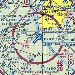
| Sectional chart |
|---|
|
 Download PDF
of official airport diagram from the FAA
| Airport distance calculator |
|---|
|
|
| Sunrise and sunset |
|---|
|
Times for 26-Mar-2026
| | Local
(UTC-4) | | Zulu
(UTC) |
|---|
| Morning civil twilight | | 07:08 | | 11:08 |
| Sunrise | | 07:35 | | 11:35 |
| Sunset | | 19:58 | | 23:58 |
| Evening civil twilight | | 20:25 | | 00:25 |
|
| Current date and time |
|---|
| Zulu (UTC) | 26-Mar-2026 14:42:14 |
|---|
| Local (UTC-4) | 26-Mar-2026 10:42:14 |
|---|
|
| METAR |
|---|
| KFWA | 261354Z 22020G27KT 10SM SCT250 19/14 A2980 RMK AO2 PK WND 21027/1354 SLP090 T01890139
|
KSMD
10nm N | 261415Z AUTO 23012G23KT 10SM CLR 21/15 A2982 RMK A01
|
KHHG
14nm SW | 261415Z AUTO 22014G22KT 10SM CLR 20/14 A2983 RMK AO2 T01950138
|
|
| TAF |
|---|
| KFWA | 261120Z 2612/2712 22018G26KT P6SM BKN190 FM262200 29015G24KT 5SM -SHRA BKN030 PROB30 2622/2624 1SM -TSRA OVC008CB FM270100 01016G23KT 2SM -RA OVC008 FM270500 02015G22KT 4SM -RA OVC015 FM270900 03015KT P6SM BKN025
|
|
| NOTAMs |
|---|
NOTAMs are issued by the DoD/FAA and will open in a separate window not controlled by AirNav.
|
|


