FAA INFORMATION EFFECTIVE 09 JULY 2026
Location
| FAA Identifier: | GEU |
| Lat/Long: | 33-31-36.9000N 112-17-42.5000W
33-31.615000N 112-17.708333W
33.5269167,-112.2951389
(estimated) |
| Elevation: | 1071.3 ft. / 326.5 m (surveyed) |
| Variation: | 12E (1995) |
| From city: | 6 miles W of GLENDALE, AZ |
| Time zone: | UTC -7 (year round; does not observe DST) |
| Zip code: | 85307 |
Airport Operations
| Airport use: | Open to the public |
| Activation date: | 06/1986 |
| Control tower: | yes |
| ARTCC: | ALBUQUERQUE CENTER |
| FSS: | PRESCOTT FLIGHT SERVICE STATION |
| NOTAMs facility: | GEU (NOTAM-D service available) |
| Attendance: | 0630-1930 |
| Pattern altitude: | 2101.3 ft. MSL
TPA HIGH PERFORMANCE 1530 FT AGL, HELICOPTER/ULTRALIGHTS 630 FT AGL. |
| Wind indicator: | lighted |
| Segmented circle: | yes |
| Lights: | WHEN ATCT CLSD ACTVT REIL RWY 01 & 19; PAPI RWY 01 & 19; MIRL RWY 01/19 - 121.00. |
| Beacon: | white-green (lighted land airport)
Operates sunset to sunrise. |
Airport Communications
| CTAF: | 121.0 |
| UNICOM: | 122.95 |
| ATIS: | 119.425 |
| WX AWOS-3: | PHONE 623-877-8609 |
| GLENDALE GROUND: | 118.0 [0600-2030 MON-FRI; 0700-1900 SAT & SUN] |
| GLENDALE TOWER: | 121.0 [0600-2030 MON-FRI; 0700-1900 SAT & SUN] |
| LUKE APPROACH: | 118.15 ;NORTH |
| PHOENIX APPROACH: | 120.7 |
| LUKE DEPARTURE: | 118.15 ;NORTH |
| PHOENIX DEPARTURE: | 120.7 |
| DSERT STAR: | 120.7 |
| SUNSS STAR: | 124.1 |
| WX ASOS at DVT (14 nm NE): | 126.5 (480-308-1230) |
| WX ASOS at PHX (15 nm E): | PHONE 602-551-6092 |
- EMERGENCY FREQUENCY 121.5 NOT MONITORED BY ATCT.
- COMMUNICATIONS PRVDD BY PRESCOTT RADIO ON FREQ 122.2 (PHOENIX RCO).
Nearby radio navigation aids
| VOR radial/distance | | VOR name | | Freq | | Var |
|---|
| PXRr277/17.2 | | PHOENIX VORTAC | | 115.60 | | 12E |
| BXKr067/26.9 | | BUCKEYE VORTAC | | 110.60 | | 14E |
| IWAr280/34.9 | | WILLIE VORTAC | | 113.30 | | 13E |
| GBNr015/39.2 | | GILA BEND VORTAC | | 116.60 | | 14E |
Airport Services
| Fuel available: | 100LL JET-A1+
100LL:SELF SERV AVBL H24.
A1+:JET A 0630-1930; FEE AFT HR - 623-877-3333. |
| Parking: | tiedowns |
| Airframe service: | MAJOR |
| Powerplant service: | MAJOR |
| Bottled oxygen: | LOW |
Runway Information
Runway 1/19
| Dimensions: | 7150 x 100 ft. / 2179 x 30 m |
| Surface: | asphalt, in good condition |
| Weight bearing capacity: | | Single wheel: | 40.0 | | Double wheel: | 60.0 |
|
| Runway edge lights: | medium intensity |
| RUNWAY 1 | | RUNWAY 19 |
| Latitude: | 33-31.083590N | | 33-32.145793N |
| Longitude: | 112-18.012923W | | 112-17.402403W |
| Elevation: | 1041.4 ft. | | 1071.3 ft. |
| Traffic pattern: | right | | left |
| Runway heading: | 014 magnetic, 026 true | | 194 magnetic, 206 true |
| Displaced threshold: | 701 ft. | | 1001 ft. |
| Declared distances: | TORA:7150 TODA:7150 ASDA:6980 LDA:6279 | | TORA:7150 TODA:7150 ASDA:7116 LDA:6115 |
| Markings: | basic, in good condition | | nonprecision, in good condition |
| Visual slope indicator: | 2-light PAPI on left (3.00 degrees glide path) | | 2-light PAPI on left (3.00 degrees glide path) |
| Runway end identifier lights: | yes | | yes |
| Touchdown point: | yes, no lights | | yes, no lights |
| Obstructions: | 13 ft. road, 201 ft. from runway, 150 ft. right of centerline
+13 FT ROAD 0-200 FT FM RWY END 150 FT R. | | 6 ft. fence, 201 ft. from runway, 150 ft. right of centerline
+12 FT BLAST FENCE 95 FT FM RWY END BOTH SIDES. |
Airport Ownership and Management from official FAA records
| Ownership: | Publicly-owned |
| Owner: | CITY OF GLENDALE
5850 W GLENDALE AVE.
GLENDALE, AZ 85301
Phone 623-930-2188 |
| Manager: | MATTHEW SMITH
6801 N. GLEN HARBOR BLVD, SUITE 201
GLENDALE, AZ 85307
Phone 623-930-2188
623-930-2188 FM 0800-1700; 602-980-0433 FM 0600-2000. |
Additional Remarks
| A30A-01 | PREFERRED FOR NOISE ABATEMENT. |
| - | MIL JET TFC 5 MI W. COYOTES & BIRDS ON & INVOF ARPT. |
| - | UNMKD & UNLGT PWR LINES 1/4 MI W PARL TO RWY. |
| - | TGL DISCOURAGED BTN 2200-0600. |
| - | AVOID NOISE SENSITIVE AREA N & SE; NOISE ABATEMENT PROC - AMGR. |
| - | HEL PAT WEST NA SS-SR. |
| - | FOR CD WHEN ATCT CLSD, CTC PHOENIX APCH AT 602-306-2565. |
Instrument Procedures
NOTE: All procedures below are presented as PDF files. If you need a reader for these files, you should download the free Adobe Reader.NOT FOR NAVIGATION. Please procure official charts for flight.
FAA instrument procedures published for use from 09 July 2026 at 0901Z to 06 August 2026 at 0900Z.
STARs - Standard Terminal Arrivals |
|---|
| DSERT TWO (RNAV) **NEW** | |
2 pages:
[1] [2] (311KB) |
| SUNSS EIGHT **NEW** | |
download (237KB) |
IAPs - Instrument Approach Procedures |
|---|
| RNAV (GPS) RWY 01 **CHANGED** | |
download (243KB) |
| RNAV (GPS) RWY 19 **CHANGED** | |
download (232KB) |
| NOTE: Special Alternate Minimums apply | |
download (143KB) |
Departure Procedures |
|---|
| BNYRD SIX (RNAV) | |
download (160KB) |
| FTHLS SIX (RNAV) | |
download (216KB) |
| GLENDALE ONE | |
download (178KB) |
| IZZZO EIGHT (RNAV) | |
download (213KB) |
| JUDTH SEVEN (RNAV) | |
download (158KB) |
| KATMN SIX (RNAV) | |
download (161KB) |
| LALUZ SIX (RNAV) | |
download (221KB) |
| MAYSA SEVEN (RNAV) | |
download (159KB) |
| SNOBL SIX (RNAV) | |
download (221KB) |
| YOTES SIX (RNAV) | |
download (185KB) |
|
|---|
| DRAKE TWO (OBSTACLE) (RNAV) | |
download (207KB) |
| NOTE: Special Take-Off Minimums/Departure Procedures apply | |
download (392KB) |
Other nearby airports with instrument procedures:
KLUF - Luke Air Force Base (4 nm W)
KGYR - Phoenix Goodyear Airport (7 nm SW)
KDVT - Phoenix Deer Valley Airport (14 nm NE)
KPHX - Phoenix Sky Harbor International Airport (15 nm E)
KSDL - Scottsdale Airport (20 nm E)
|
|

Road maps at:
MapQuest
Bing
Google
| Aerial photo |
|---|
WARNING: Photo may not be current or correct
 Photo by Vicki Eifert
Photo taken 01-Jun-2017
looking south.
Photo by Vicki Eifert
Photo taken 01-Jun-2017
looking south.
Do you have a better or more recent aerial photo of Glendale Regional Airport that you would like to share? If so, please send us your photo.
|
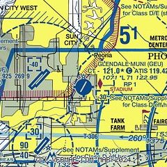
| Sectional chart |
|---|
|
 Download PDF
of official airport diagram from the FAA
| Airport distance calculator |
|---|
|
|
| Sunrise and sunset |
|---|
|
Times for 26-Jul-2026
| | Local
(UTC-7) | | Zulu
(UTC) |
|---|
| Morning civil twilight | | 05:11 | | 12:11 |
| Sunrise | | 05:38 | | 12:38 |
| Sunset | | 19:33 | | 02:33 |
| Evening civil twilight | | 20:01 | | 03:01 |
|
| Current date and time |
|---|
| Zulu (UTC) | 27-Jul-2026 06:57:27 |
|---|
| Local (UTC-7) | 26-Jul-2026 23:57:27 |
|---|
|
| METAR |
|---|
| KGEU | 270147Z 19010KT 10SM FEW340 42/14 A2974 RMK LAST
|
KLUF
4nm W | 270555Z AUTO 21011KT 10SM CLR 39/14 A2981 RMK AO2 SLP075 T03920142 10438 20389 50015 $
|
KGYR
8nm SW | 270347Z 22012KT 10SM FEW100 SCT250 41/18 A2980 RMK LAST
|
KPHX
13nm SE | 270651Z 28015KT 10SM SCT250 39/15 A2982 RMK AO2 SLP073 T03890150 404330328 $
|
KDVT
15nm NE | 270653Z AUTO 32004KT 10SM CLR 36/17 A2987 RMK AO2 SLP082 T03610167 404220289
|
KSDL
20nm E | 270653Z AUTO 26007KT 10SM CLR 37/16 A2987 RMK AO2 SLP083 T03720156 404220300 $
|
|
| TAF |
|---|
KPHX
13nm SE | 270522Z 2706/2812 26012KT P6SM FEW150 SCT250 FM271200 25007KT P6SM FEW150 FEW250 FM272100 27011G19KT P6SM FEW150 FEW250
|
KDVT
15nm NE | 270522Z 2706/2806 23010KT P6SM FEW150 SCT250 FM271200 20005KT P6SM FEW150 SCT250 FM271900 24010G18KT P6SM FEW150 FEW250
|
KSDL
20nm E | 270522Z 2706/2806 23005KT P6SM FEW150 SCT250 FM271100 VRB04KT P6SM FEW150 SCT250 FM271700 25008KT P6SM FEW150 FEW250
|
|
| NOTAMs |
|---|
NOTAMs are issued by the DoD/FAA and will open in a separate window not controlled by AirNav.
|
|


