FAA INFORMATION EFFECTIVE 09 JULY 2026
Location
| FAA Identifier: | IKV |
| Lat/Long: | 41-41-28.8485N 093-33-58.8569W
41-41.480808N 093-33.980948W
41.6913468,-93.5663491
(estimated) |
| Elevation: | 909.9 ft. / 277.3 m (surveyed) |
| Variation: | 03E (2000) |
| From city: | 1 mile SE of ANKENY, IA |
| Time zone: | UTC -5 (UTC -6 during Standard Time) |
| Zip code: | 50021 |
Airport Operations
| Airport use: | Open to the public |
| Activation date: | 02/1994 |
| Control tower: | no |
| ARTCC: | MINNEAPOLIS CENTER |
| FSS: | FORT DODGE FLIGHT SERVICE STATION |
| NOTAMs facility: | IKV (NOTAM-D service available) |
| Attendance: | 0600-2100 |
| Wind indicator: | lighted |
| Segmented circle: | yes |
| Lights: | ACTVT PAPI RY 4/22; MIRL RWYS 04/22 & 18/36; REIL RWYS 4 & 18/36 - CTAF |
| Beacon: | white-green (lighted land airport)
Operates sunset to sunrise. |
Airport Communications
| CTAF: | 122.9 |
| WX AWOS-3: | 119.175 (515-965-5764) |
| DES MOINES APPROACH: | 123.9 |
| DES MOINES DEPARTURE: | 123.9 |
| CLEARANCE DELIVERY: | 126.65 |
| WX ASOS at DSM (10 nm SW): | 119.55 (515-218-1035) |
| WX ASOS at AMW (18 nm N): | 132.025 (515-233-2611) |
- FREQ 122.900 IS ALSO USED AS UNICOM.
Nearby radio navigation aids
| VOR radial/distance | | VOR name | | Freq | | Var |
|---|
| DSMr007/15.7 | | DES MOINES VORTAC | | 117.50 | | 07E |
| TNUr252/21.2 | | NEWTON VOR/DME | | 112.50 | | 03E |
Airport Services
| Fuel available: | 100LL JET-A |
| Parking: | hangars and tiedowns |
| Airframe service: | MAJOR |
| Powerplant service: | MAJOR |
| Bottled oxygen: | HIGH |
| Bulk oxygen: | HIGH |
Runway Information
Runway 18/36
| Dimensions: | 5500 x 100 ft. / 1676 x 30 m |
| Surface: | concrete, in excellent condition |
| Weight bearing capacity: | | PCN 12 /R/B/W/U | | Single wheel: | 30.0 | | Double wheel: | 40.0 |
|
| Runway edge lights: | medium intensity |
| RUNWAY 18 | | RUNWAY 36 |
| Latitude: | 41-41.859098N | | 41-40.953477N |
| Longitude: | 093-33.949378W | | 093-33.949608W |
| Elevation: | 903.4 ft. | | 887.8 ft. |
| Traffic pattern: | left | | right |
| Runway heading: | 177 magnetic, 180 true | | 357 magnetic, 360 true |
| Markings: | nonprecision, in good condition | | precision, in good condition |
| Visual slope indicator: | 2-light PAPI on left (3.00 degrees glide path) | | 2-light PAPI on left (3.00 degrees glide path) |
| Runway end identifier lights: | yes | | yes |
| Touchdown point: | yes, no lights | | yes, no lights |
| Instrument approach: | | | ILS/DME |
| Obstructions: | 49 ft. tree, 2025 ft. from runway, 144 ft. left of centerline, 37:1 slope to clear | | 20 ft. tree, 355 ft. from runway, 267 ft. right of centerline, 7:1 slope to clear
47 FT TREE 177 FT FM TWY END 283 FT R OF CNTRLN, 7:1 APCH SLOPE. |
Runway 4/22
| Dimensions: | 4200 x 75 ft. / 1280 x 23 m |
| Surface: | concrete, in excellent condition |
| Weight bearing capacity: | | PCN 12 /R/B/W/U | | Single wheel: | 30.0 | | Double wheel: | 40.0 |
|
| Runway edge lights: | medium intensity |
| RUNWAY 4 | | RUNWAY 22 |
| Latitude: | 41-41.333868N | | 41-41.822877N |
| Longitude: | 093-34.348403W | | 093-33.695857W |
| Elevation: | 909.9 ft. | | 902.4 ft. |
| Traffic pattern: | right | | left |
| Runway heading: | 042 magnetic, 045 true | | 222 magnetic, 225 true |
| Declared distances: | TORA:4200 TODA:4200 ASDA:4200 LDA:4200 | | TORA:4200 TODA:4200 ASDA:4200 LDA:4200 |
| Markings: | nonprecision, in good condition | | nonprecision, in good condition |
| Visual slope indicator: | 2-light PAPI on left (4.00 degrees glide path) | | 2-light PAPI on left (3.00 degrees glide path) |
| Runway end identifier lights: | yes | | yes |
| Touchdown point: | yes, no lights | | yes, no lights |
| Obstructions: | 31 ft. tree, 981 ft. from runway, 100 ft. left of centerline, 25:1 slope to clear | | 56 ft. trees, 1178 ft. from runway, 146 ft. left of centerline, 17:1 slope to clear |
Airport Ownership and Management from official FAA records
| Ownership: | Publicly-owned |
| Owner: | POLK COUNTY AVIATION AUTH
410 WEST 1ST STREET
ANKENY, IA 50023
Phone 515-965-6400 |
| Manager: | DAVE KALWISHKY
3700 SE CONVENIENCE BOULEVARD
ANKENY, IA 50023
Phone 515-965-6428 |
Additional Remarks
| - | EXEC 1 AVIATION - (515) 965-1020. |
| - | AMGR REQ USE OF PREFERENTIAL RY 18 WHEN WINDS ARE LESS THAN 5 KNOTS. |
| - | FOR CD CTC DES MOINES ATCT ON 126.65 OR CALL 515-974- 8016. |
Instrument Procedures
NOTE: All procedures below are presented as PDF files. If you need a reader for these files, you should download the free Adobe Reader.NOT FOR NAVIGATION. Please procure official charts for flight.
FAA instrument procedures published for use from 09 July 2026 at 0901Z to 06 August 2026 at 0900Z.
IAPs - Instrument Approach Procedures |
|---|
| ILS OR LOC RWY 36 | |
download (224KB) |
| RNAV (GPS) RWY 18 | |
download (224KB) |
| RNAV (GPS) RWY 22 | |
download (193KB) |
| RNAV (GPS) RWY 36 | |
download (215KB) |
| NOTE: Special Alternate Minimums apply | |
download (43KB) |
| NOTE: Special Take-Off Minimums/Departure Procedures apply | |
download (245KB) |
Other nearby airports with instrument procedures:
KDSM - Des Moines International Airport (10 nm SW)
KAMW - Ames Municipal Airport (18 nm N)
KTNU - Newton Municipal Airport-Earl Johnson Field (24 nm E)
KBNW - Boone Municipal Airport (25 nm NW)
KPRO - Perry Municipal Airport (28 nm W)
|
|

Road maps at:
MapQuest
Bing
Google
| Aerial photo |
|---|
WARNING: Photo may not be current or correct
 Photo by Trey Buttriss
Photo taken 12-May-2008
Photo by Trey Buttriss
Photo taken 12-May-2008
Do you have a better or more recent aerial photo of Ankeny Regional Airport that you would like to share? If so, please send us your photo.
|
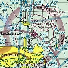
| Sectional chart |
|---|
|
CAUTION: Diagram may not be current

| Airport distance calculator |
|---|
|
|
| Sunrise and sunset |
|---|
|
Times for 20-Jul-2026
| | Local
(UTC-5) | | Zulu
(UTC) |
|---|
| Morning civil twilight | | 05:26 | | 10:26 |
| Sunrise | | 05:58 | | 10:58 |
| Sunset | | 20:43 | | 01:43 |
| Evening civil twilight | | 21:16 | | 02:16 |
|
| Current date and time |
|---|
| Zulu (UTC) | 20-Jul-2026 11:19:30 |
|---|
| Local (UTC-5) | 20-Jul-2026 06:19:30 |
|---|
|
| METAR |
|---|
| KIKV | 201055Z AUTO VRB03KT 10SM CLR 23/21 A2989 RMK AO2
|
KDSM
10nm SW | 201054Z 16006KT 6SM BR FEW060 23/20 A2988 RMK AO2 SLP109 T02280200 $
|
KAMW
18nm N | 201053Z AUTO 14004KT 4SM BR CLR 21/20 A2987 RMK AO2 SLP105 T02060200
|
|
| TAF |
|---|
KDSM
10nm SW | 200520Z 2006/2106 14005KT P6SM BKN220 FM201000 18007KT P6SM SCT040 BKN150 FM201700 23011G22KT P6SM FEW040 PROB30 2102/2106 5SM -TSRA BKN050CB
|
|
| NOTAMs |
|---|
NOTAMs are issued by the DoD/FAA and will open in a separate window not controlled by AirNav.
|
|


