FAA INFORMATION EFFECTIVE 09 JULY 2026
Location
| FAA Identifier: | IXA |
| Lat/Long: | 36-19-47.2500N 077-38-06.8310W
36-19.787500N 077-38.113850W
36.3297917,-77.6352308
(estimated) |
| Elevation: | 144.3 ft. / 44.0 m (surveyed) |
| Variation: | 10W (2010) |
| From city: | 8 miles S of ROANOKE RAPIDS, NC |
| Time zone: | UTC -4 (UTC -5 during Standard Time) |
| Zip code: | 27839 |
Airport Operations
| Airport use: | Open to the public |
| Activation date: | 02/2009 |
| Control tower: | no |
| ARTCC: | WASHINGTON CENTER |
| FSS: | RALEIGH FLIGHT SERVICE STATION |
| NOTAMs facility: | IXA (NOTAM-D service available) |
| Attendance: | SUN 1200-1700, ALL MON-SAT 0800-1700
UNATNDD NEW YEARS DAY, EASTER, JULY 4, THANKSGIVING, CHRISTMAS.
FOR SVC AFT HRS CTC 252-578-3774. |
| Wind indicator: | lighted |
| Segmented circle: | yes |
| Lights: | ACTVT MALSR RWY 20; REIL RWY 02; PAPI RWY 02 & 20; HIRL RWY 02/20 - CTAF. |
| Beacon: | white-green (lighted land airport)
Operates sunset to sunrise. |
Airport Communications
| CTAF/UNICOM: | 123.075 |
| WX AWOS-3PT: | 119.975 (252-583-3446) |
- APCH/DEP SVC PRVDD BY WASHINGTON ARTCC ON FREQS 132.025/290.425 (LAWRENCEVILLE RCAG).
Nearby radio navigation aids
| VOR radial/distance | | VOR name | | Freq | | Var |
|---|
| TYIr014/21.4 | | TAR RIVER VORTAC | | 117.80 | | 05W |
| NDB name | | Hdg/Dist | | Freq | | Var | | ID |
|---|
| ALWOOD | | 350/39.5 | | 230 | | 09W | | AQE | .- --.- . |
Airport Services
| Fuel available: | 100LL JET-A1+
100LL:100LL AND JET-A FUEL AVBL 24 HRS SELF SERVICE W/ CREDIT CARD. |
| Parking: | tiedowns |
Runway Information
Runway 2/20
| Dimensions: | 5500 x 100 ft. / 1676 x 30 m |
| Surface: | asphalt, in excellent condition |
| Weight bearing capacity: | | Single wheel: | 45.0 | | Double wheel: | 65.0 |
|
| Runway edge lights: | high intensity |
| RUNWAY 2 | | RUNWAY 20 |
| Latitude: | 36-19.339608N | | 36-20.235387N |
| Longitude: | 077-38.199315W | | 077-38.028367W |
| Elevation: | 140.7 ft. | | 138.8 ft. |
| Traffic pattern: | left | | left |
| Runway heading: | 019 magnetic, 009 true | | 199 magnetic, 189 true |
| Markings: | nonprecision, in good condition | | precision, in good condition |
| Visual slope indicator: | 2-light PAPI on left (3.00 degrees glide path) | | 2-light PAPI on left (3.00 degrees glide path) |
| Approach lights: | | | MALSR: 1,400 foot medium intensity approach lighting system with runway alignment indicator lights |
| Runway end identifier lights: | yes | | no |
| Touchdown point: | yes, no lights | | yes, no lights |
| Obstructions: | 26 ft. trees, 890 ft. from runway, 217 ft. left of centerline, 26:1 slope to clear | | 25 ft. trees, 1590 ft. from runway, 148 ft. left of centerline, 31:1 slope to clear |
Airport Ownership and Management from official FAA records
| Ownership: | Publicly-owned |
| Owner: | HALIFAX-NORTHAMPTON RGNL ARPT AUTH
10 NORTH KING ST.
HALIFAX, NC 27839
Phone 252-583-1131 |
| Manager: | FRED DRAPER
700 GREGORY FARM RD.
HALIFAX, NC 27839
Phone 252-583-3492 |
Additional Remarks
| - | BIRDS ON & INVOF ARPT. |
| - | AGRICULTURE EQUIP OCNLY ADJ TO RWY 02/20. |
| - | FOR CD CTC WASHINGTON ARTCC AT 703-771-3587. |
Instrument Procedures
NOTE: All procedures below are presented as PDF files. If you need a reader for these files, you should download the free Adobe Reader.NOT FOR NAVIGATION. Please procure official charts for flight.
FAA instrument procedures published for use from 09 July 2026 at 0901Z to 06 August 2026 at 0900Z.
IAPs - Instrument Approach Procedures |
|---|
| RNAV (GPS) RWY 02 | |
download (218KB) |
| RNAV (GPS) RWY 20 | |
download (221KB) |
| NOTE: Special Alternate Minimums apply | |
download (168KB) |
| NOTE: Special Take-Off Minimums/Departure Procedures apply | |
download (363KB) |
Other nearby airports with instrument procedures:
KASJ - Tri-County Airport at Henry Joyner Field (23 nm E)
KEMV - Emporia-Greensville Regional Airport (23 nm N)
KETC - Tarboro-Edgecombe Airport (24 nm S)
KLVL - Brunswick County Airport (28 nm N)
KAVC - Mecklenburg-Brunswick Regional Airport (30 nm NW)
|
|
| Aerial photo |
|---|
WARNING: Photo may not be current or correct

Do you have a better or more recent aerial photo of Halifax/Northampton Regional Airport that you would like to share? If so, please send us your photo.
|
| Sectional chart |
|---|
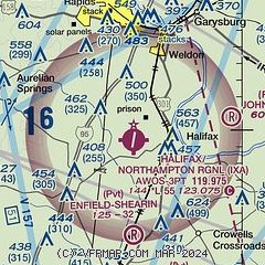
|
| Airport distance calculator |
|---|
|
|
| Sunrise and sunset |
|---|
|
Times for 28-Jul-2026
| | Local
(UTC-4) | | Zulu
(UTC) |
|---|
| Morning civil twilight | | 05:46 | | 09:46 |
| Sunrise | | 06:15 | | 10:15 |
| Sunset | | 20:19 | | 00:19 |
| Evening civil twilight | | 20:48 | | 00:48 |
|
| Current date and time |
|---|
| Zulu (UTC) | 28-Jul-2026 04:48:13 |
|---|
| Local (UTC-4) | 28-Jul-2026 00:48:13 |
|---|
|
| METAR |
|---|
| KIXA | 280435Z AUTO 00000KT 7SM CLR 21/21 A2982 RMK AO2
|
|
| TAF |
|---|
KRWI
32nm SW | 271720Z 2718/2818 VRB04KT P6SM FEW025 SCT100 TEMPO 2809/2812 4SM BR FEW025 FM281200 22009KT P6SM FEW050 BKN250
|
|
| NOTAMs |
|---|
NOTAMs are issued by the DoD/FAA and will open in a separate window not controlled by AirNav.
|
|

