FAA INFORMATION EFFECTIVE 16 APRIL 2026
Location
| FAA Identifier: | JEF |
| Lat/Long: | 38-35-28.2250N 092-09-22.1210W
38-35.470417N 092-09.368683W
38.5911736,-92.1561447
(estimated) |
| Elevation: | 549.4 ft. / 167.5 m (surveyed) |
| Variation: | 01W (2025) |
| From city: | 2 miles NE of JEFFERSON CITY, MO |
| Time zone: | UTC -5 (UTC -6 during Standard Time) |
| Zip code: | 65043 |
Airport Operations
| Airport use: | Open to the public |
| Activation date: | 02/1949 |
| Control tower: | yes |
| ARTCC: | KANSAS CITY CENTER |
| FSS: | COLUMBIA FLIGHT SERVICE STATION |
| NOTAMs facility: | JEF (NOTAM-D service available) |
| Attendance: | 0630-2030 |
| Wind indicator: | lighted |
| Segmented circle: | no |
| Lights: | WHEN ATCT CLSD ACTVT MALSR RWY 30; REIL RWYS 9, 12, 27; HIRL RWY 12/30; & TWY A LGTS - CTAF. VASI RWYS 12 & 30 OPR CONSLY. |
| Beacon: | white-green (lighted land airport)
Operates sunset to sunrise. |
Airport Communications
| CTAF: | 125.6 |
| UNICOM: | 122.95 |
| WX ASOS: | 133.625 (573-635-9266) |
| JEFFERSON CITY GROUND: | 121.7 [0600-2130] |
| JEFFERSON CITY TOWER: | 125.6 41.95FM [0600-2130] |
| MIZZU APPROACH: | 124.375 |
| MIZZU DEPARTURE: | 124.375 |
| ARNG OPS: | 142.4 242.4 41.65 |
| NG OPS: | 118.55 |
| WX ASOS at COU (14 nm N): | 128.45 (573-488-3025) |
Nearby radio navigation aids
| VOR radial/distance | | VOR name | | Freq | | Var |
|---|
| COUr168/13.5 | | COLUMBIA VOR/DME | | 110.20 | | 00E |
| HLVr176/31.4 | | HALLSVILLE VORTAC | | 114.20 | | 06E |
| VIHr315/33.7 | | VICHY VOR/DME | | 117.70 | | 06E |
| SHYr032/39.1 | | SUNSHINE VOR/DME | | 108.40 | | 00E |
| NDB name | | Hdg/Dist | | Freq | | Var | | ID |
|---|
| ALGOA | | 304/4.7 | | 397 | | 01W | | JE | .--- . |
Airport Services
| Fuel available: | 100LL JET-A
100LL:AVBL FROM 0630 - 2030 Z++. |
| Parking: | hangars and tiedowns |
| Airframe service: | MAJOR |
| Powerplant service: | MAJOR |
| Bottled oxygen: | HIGH/LOW |
| Bulk oxygen: | NONE |
Runway Information
Runway 12/30
| Dimensions: | 6000 x 100 ft. / 1829 x 30 m |
| Surface: | concrete/grooved, in excellent condition |
| Weight bearing capacity: | | PCN 32 /R/D/W/T | | Single wheel: | 85.0 | | Double wheel: | 104.0 | | Double tandem: | 168.0 |
|
| Runway edge lights: | high intensity |
| RUNWAY 12 | | RUNWAY 30 |
| Latitude: | 38-35.744125N | | 38-35.212682N |
| Longitude: | 092-09.830682W | | 092-08.768802W |
| Elevation: | 547.2 ft. | | 547.3 ft. |
| Traffic pattern: | left | | left |
| Runway heading: | 124 magnetic, 123 true | | 304 magnetic, 303 true |
| Markings: | precision, in good condition | | precision, in good condition |
| Visual slope indicator: | 4-box VASI on left (3.50 degrees glide path) | | 4-box VASI on left (3.00 degrees glide path) |
| Approach lights: | | | MALSR: 1,400 foot medium intensity approach lighting system with runway alignment indicator lights |
| Runway end identifier lights: | yes | | |
| Touchdown point: | yes, no lights | | yes, no lights |
| Instrument approach: | | | ILS/DME |
Runway 9/27
| Dimensions: | 3401 x 75 ft. / 1037 x 23 m |
| Surface: | concrete, in good condition |
| Weight bearing capacity: | | PCN 11 /R/D/W/T | | Single wheel: | 33.5 | | Double wheel: | 44.0 |
|
| Runway edge lights: | medium intensity |
| RUNWAY 9 | | RUNWAY 27 |
| Latitude: | 38-35.461637N | | 38-35.450932N |
| Longitude: | 092-09.847242W | | 092-09.133418W |
| Elevation: | 546.3 ft. | | 545.9 ft. |
| Traffic pattern: | left | | left |
| Runway heading: | 092 magnetic, 091 true | | 272 magnetic, 271 true |
| Markings: | basic, in good condition | | basic, in good condition |
| Visual slope indicator: | 4-light PAPI on left (3.00 degrees glide path) | | 4-light PAPI on left (3.00 degrees glide path) |
| Runway end identifier lights: | yes | | yes |
| Touchdown point: | yes, no lights | | yes, no lights |
| Obstructions: | 23 ft. hangar, 600 ft. from runway, 230 ft. left of centerline, 17:1 slope to clear | | 53 ft. trees, 1127 ft. from runway, 75 ft. both sides of centerline, 17:1 slope to clear |
Airport Ownership and Management from official FAA records
| Ownership: | Publicly-owned |
| Owner: | CITY OF JEFFERSON
320 E. MCCARTY ST.
JEFFERSON CITY, MO 65101
Phone 573-634-6469 |
| Manager: | ERIC BOWERS
320 E. MCCARTY ST.
JEFFERSON CITY, MO 65101
Phone 573-634-6469 |
Additional Remarks
| - | LIGHT TO MODERATE BIRD ACTVTY INVOF ARPT. |
| - | ENTRANCES TO E & S HANGARS, NOT VISIBLE BY TWR. |
| - | ARFF AVBL WITH PPR 24 HOURS 573-634-6469. |
| - | FOR CD CTC MIZZOU APCH AT 417-868-5620/5619. |
Instrument Procedures
NOTE: All procedures below are presented as PDF files. If you need a reader for these files, you should download the free Adobe Reader.NOT FOR NAVIGATION. Please procure official charts for flight.
FAA instrument procedures published for use from 16 April 2026 at 0901Z to 14 May 2026 at 0900Z.
IAPs - Instrument Approach Procedures |
|---|
| ILS OR LOC RWY 30 | |
download (282KB) |
| RNAV (GPS) RWY 12 | |
download (226KB) |
| RNAV (GPS) RWY 30 | |
download (315KB) |
| NOTE: Special Alternate Minimums apply | |
download (145KB) |
| NOTE: Special Take-Off Minimums/Departure Procedures apply | |
download (425KB) |
Other nearby airports with instrument procedures:
KCOU - Columbia Regional Airport (14 nm N)
KFTT - Elton Hensley Memorial Airport (16 nm NE)
H79 - Eldon Model Airpark (24 nm SW)
KVER - Jesse Viertel Memorial Airport (33 nm NW)
KVIH - Rolla National Airport (33 nm SE)
|
|

Road maps at:
MapQuest
Bing
Google
| Aerial photo |
|---|
WARNING: Photo may not be current or correct
 Photo by Gary Baitinger
Photo taken 23-Nov-2015
looking west.
Photo by Gary Baitinger
Photo taken 23-Nov-2015
looking west.
Do you have a better or more recent aerial photo of Jefferson City Memorial Airport that you would like to share? If so, please send us your photo.
|
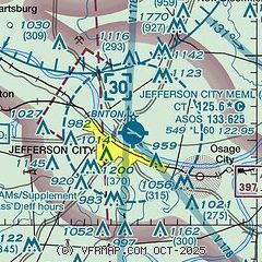
| Sectional chart |
|---|
|
 Download PDF
of official airport diagram from the FAA
| Airport distance calculator |
|---|
|
|
| Sunrise and sunset |
|---|
|
Times for 06-May-2026
| | Local
(UTC-5) | | Zulu
(UTC) |
|---|
| Morning civil twilight | | 05:38 | | 10:38 |
| Sunrise | | 06:07 | | 11:07 |
| Sunset | | 20:04 | | 01:04 |
| Evening civil twilight | | 20:33 | | 01:33 |
|
| Current date and time |
|---|
| Zulu (UTC) | 06-May-2026 13:33:01 |
|---|
| Local (UTC-5) | 06-May-2026 08:33:01 |
|---|
|
| METAR |
|---|
| KJEF | 061253Z 00000KT 10SM BKN065 OVC080 09/07 A3002 RMK AO2 SLP158 T00890067
|
KCOU
14nm N | 061254Z 35003KT 10SM SCT075 OVC100 08/05 A3001 RMK AO2 SLP163 T00830050
|
|
| TAF |
|---|
| KJEF | 061120Z 0612/0712 VRB04KT P6SM OVC080 FM061600 33006KT P6SM BKN080 FM070000 VRB04KT P6SM BKN250
|
KCOU
14nm N | 061120Z 0612/0712 VRB04KT P6SM OVC080 FM061600 33007KT P6SM BKN080 FM070000 VRB04KT P6SM BKN250
|
|
| NOTAMs |
|---|
NOTAMs are issued by the DoD/FAA and will open in a separate window not controlled by AirNav.
|
|


