FAA INFORMATION EFFECTIVE 09 JULY 2026
Location
| FAA Identifier: | LBT |
| Lat/Long: | 34-36-35.3200N 079-03-34.3790W
34-36.588667N 079-03.572983W
34.6098111,-79.0595497
(estimated) |
| Elevation: | 124.6 ft. / 38.0 m (surveyed) |
| Variation: | 08W (2000) |
| From city: | 3 miles W of LUMBERTON, NC |
| Time zone: | UTC -4 (UTC -5 during Standard Time) |
| Zip code: | 28358 |
Airport Operations
| Airport use: | Open to the public |
| Activation date: | 01/1943 |
| Control tower: | no |
| ARTCC: | WASHINGTON CENTER |
| FSS: | RALEIGH FLIGHT SERVICE STATION |
| NOTAMs facility: | LBT (NOTAM-D service available) |
| Attendance: | SAT-SUN 1000-1700, ALL MON-FRI 0800-1700
UNATNDD CHRISTMAS & THANKSGIVING. |
| Wind indicator: | lighted |
| Segmented circle: | yes |
| Lights: | ACTVT REIL RWY 05 & 23; PAPI RWY 05 & 23; MIRL RWY 05/23 - CTAF. |
| Beacon: | white-green (lighted land airport)
Operates sunset to sunrise. |
Airport Communications
| CTAF/UNICOM: | 122.8 |
| WX ASOS: | 134.775 (910-739-7120) |
| FAYETTEVILLE APPROACH: | 133.0 |
| FAYETTEVILLE DEPARTURE: | 133.0 |
| WX ASOS at MEB (19 nm NW): | 134.125 (910-844-5338) |
Nearby radio navigation aids
| VOR radial/distance | | VOR name | | Freq | | Var |
|---|
| FAYr206/24.3 | | FAYETTEVILLE VOR/DME | | 114.85 | | 04W |
| FLOr056/37.2 | | FLORENCE VORTAC | | 115.20 | | 03W |
| NDB name | | Hdg/Dist | | Freq | | Var | | ID |
|---|
| JIGEL | | 053/5.5 | | 384 | | 08W | | JB | .--- -... |
Airport Services
| Fuel available: | 100LL JET-A1+ MOGAS
A1+:PPR FOR JET A FUEL AFTER HRS, CALL AMGR 910-608-1219.
100LL:100LL FUEL 24 HR CREDIT CARD SVC AVBL. |
| Parking: | hangars and tiedowns |
| Airframe service: | MAJOR |
| Powerplant service: | MAJOR |
| Bottled oxygen: | NONE |
| Bulk oxygen: | NONE |
Runway Information
Runway 5/23
| Dimensions: | 5505 x 150 ft. / 1678 x 46 m |
| Surface: | asphalt, in excellent condition |
| Weight bearing capacity: | | PCN 22 /F/C/X/T | | Single wheel: | 15.0 | | Double wheel: | 80.0 |
|
| Runway edge lights: | medium intensity |
| RUNWAY 5 | | RUNWAY 23 |
| Latitude: | 34-36.256428N | | 34-36.896825N |
| Longitude: | 079-04.038800W | | 079-03.261107W |
| Elevation: | 123.2 ft. | | 123.1 ft. |
| Traffic pattern: | left | | left |
| Runway heading: | 053 magnetic, 045 true | | 233 magnetic, 225 true |
| Displaced threshold: | 162 ft. | | no |
| Markings: | precision, in good condition | | precision, in good condition |
| Visual slope indicator: | 4-light PAPI on left (3.00 degrees glide path) | | 2-light PAPI on left (3.20 degrees glide path) |
| Runway end identifier lights: | yes | | yes |
| Touchdown point: | yes, no lights | | yes, no lights |
| Instrument approach: | ILS | | |
| Obstructions: | 103 ft. trees, 3498 ft. from runway, 79 ft. left of centerline, 32:1 slope to clear
APCH RATIO 26:1 AT DSPLCD THR. | | 77 ft. trees, 1776 ft. from runway, 259 ft. left of centerline, 20:1 slope to clear
61 FT TREES 0-200 FT FM THR OFFSET 306 FT LEFT. |
Runway 13/31
| Dimensions: | 5007 x 75 ft. / 1526 x 23 m |
| Surface: | asphalt, in good condition |
| Weight bearing capacity: | |
| RUNWAY 13 | | RUNWAY 31 |
| Latitude: | 34-36.838298N | | 34-36.365472N |
| Longitude: | 079-03.897517W | | 079-03.079217W |
| Elevation: | 123.8 ft. | | 121.3 ft. |
| Traffic pattern: | left | | left |
| Runway heading: | 133 magnetic, 125 true | | 313 magnetic, 305 true |
| Displaced threshold: | no | | 590 ft. |
| Markings: | nonprecision, in good condition | | nonprecision, in good condition |
| Touchdown point: | yes, no lights | | yes, no lights |
| Obstructions: | 48 ft. trees, 476 ft. from runway, 174 ft. left of centerline, 5:1 slope to clear
9 FT FENCE 100 FT TO 200 FT FM THR OFFSET 240 FT L AND R OF CNTRLN. | | 53 ft. trees, 279 ft. from runway, 216 ft. right of centerline, 1:1 slope to clear
15 FT ROAD 170 FT FM THR BOTH SIDES AND 10 FT FENCE 154 FT FM THR BOTH SIDES. |
Airport Ownership and Management from official FAA records
| Ownership: | Publicly-owned |
| Owner: | CITY OF LUMBERTON
P. O. BOX 1388
LUMBERTON, NC 28359
Phone 910-671-3800 |
| Manager: | GARY LEWIS
163 AIRPORT BLVD
LUMBERTON, NC 28358
Phone 910-739-6480 |
Additional Remarks
| - | RWYS 05/23 & 13/31 NO LN OF SIGHT BTN RWY ENDS. |
| - | DEER & BIRDS ON & INVOF ARPT. |
| - | FARMING OPS NEAR RWYS AND TWYS. |
| - | FOR CD CTC WASHINGTON ARTCC AT 703-771-3587. |
Instrument Procedures
NOTE: All procedures below are presented as PDF files. If you need a reader for these files, you should download the free Adobe Reader.NOT FOR NAVIGATION. Please procure official charts for flight.
FAA instrument procedures published for use from 09 July 2026 at 0901Z to 06 August 2026 at 0900Z.
IAPs - Instrument Approach Procedures |
|---|
| ILS OR LOC RWY 05 | |
download (254KB) |
| RNAV (GPS) RWY 05 | |
download (243KB) |
| RNAV (GPS) RWY 13 | |
download (232KB) |
| RNAV (GPS) RWY 23 | |
download (256KB) |
| NOTE: Special Alternate Minimums apply | |
download (39KB) |
| NOTE: Special Take-Off Minimums/Departure Procedures apply | |
download |
Other nearby airports with instrument procedures:
KDLC - Dillon County Airport (18 nm SW)
KMEB - Laurinburg/Maxton Airport (19 nm NW)
KEYF - Curtis L Brown Jr. Field Airport (24 nm E)
KFAY - Fayetteville Regional Airport/Grannis Field (25 nm N)
5W4 - P K Airpark (25 nm N)
|
|

Road maps at:
MapQuest
Bing
Google
| Aerial photo |
|---|
WARNING: Photo may not be current or correct
 Photo by Mr. Bobby Jones
Photo taken 07-Jul-2014
looking northwest.
Photo by Mr. Bobby Jones
Photo taken 07-Jul-2014
looking northwest.
Do you have a better or more recent aerial photo of Lumberton Regional Airport that you would like to share? If so, please send us your photo.
|
| Sectional chart |
|---|
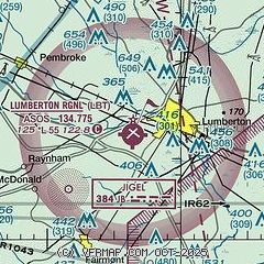
|
CAUTION: Diagram may not be current

| Airport distance calculator |
|---|
|
|
| Sunrise and sunset |
|---|
|
Times for 17-Jul-2026
| | Local
(UTC-4) | | Zulu
(UTC) |
|---|
| Morning civil twilight | | 05:48 | | 09:48 |
| Sunrise | | 06:17 | | 10:17 |
| Sunset | | 20:28 | | 00:28 |
| Evening civil twilight | | 20:57 | | 00:57 |
|
| Current date and time |
|---|
| Zulu (UTC) | 18-Jul-2026 02:53:41 |
|---|
| Local (UTC-4) | 17-Jul-2026 22:53:41 |
|---|
|
| METAR |
|---|
| KLBT | 180156Z AUTO 00000KT 10SM CLR 28/24 A3001 RMK AO2 SLP159 T02830244
|
KMEB
18nm NW | 180152Z AUTO 19006KT 10SM CLR 28/24 A3001 RMK AO2 SLP160 T02830239
|
|
| TAF |
|---|
| KLBT | 171720Z 1718/1818 VRB04KT P6SM SCT050 FM172000 18006KT P6SM SKC
|
|
| NOTAMs |
|---|
NOTAMs are issued by the DoD/FAA and will open in a separate window not controlled by AirNav.
|
|


