FAA INFORMATION EFFECTIVE 09 JULY 2026
Location
| FAA Identifier: | LFK |
| Lat/Long: | 31-14-02.5000N 094-45-00.0000W
31-14.041667N 094-45.000000W
31.2340278,-94.7500000
(estimated) |
| Elevation: | 295.6 ft. / 90.1 m (surveyed) |
| Variation: | 02E (2020) |
| From city: | 7 miles SW of LUFKIN, TX |
| Time zone: | UTC -5 (UTC -6 during Standard Time) |
| Zip code: | 75941 |
Airport Operations
| Airport use: | Open to the public |
| Activation date: | 08/1944 |
| Control tower: | no |
| ARTCC: | HOUSTON CENTER |
| FSS: | MONTGOMERY COUNTY FLIGHT SERVICE STATION |
| NOTAMs facility: | LFK (NOTAM-D service available) |
| Attendance: | MON-FRI 0700-1900, ALL SAT-SUN 0900-1900 |
| Wind indicator: | lighted |
| Segmented circle: | yes |
| Lights: | DUSK-DAWN. MIRL RWYS 07/25 & 16/34 PRESET MED INTST; TO INCR INTST AND ACTVT MALSR RWY 07 - CTAF. |
| Beacon: | white-green (lighted land airport)
Operates sunset to sunrise. |
Airport Communications
| CTAF/UNICOM: | 123.0 |
| WX ASOS: | 120.625 (936-308-0974) |
- UNICOM MNT FM 0700-1900.
- APCH/DEP CTL SVC PRVDD BY HOUSTON ARTCC (ZHU) ON FREQS 125.175/285.575 (LUFKIN RCAG).
Nearby radio navigation aids
| VOR radial/distance | | VOR name | | Freq | | Var |
|---|
| LFKr333/4.6 | | LUFKIN VORTAC | | 112.10 | | 05E |
| NDB name | | Hdg/Dist | | Freq | | Var | | ID |
|---|
| FLUFY | | 075/4.0 | | 350 | | 02E | | LF | .-.. ..-. |
Airport Services
| Fuel available: | 100LL JET-A+
100LL:SVC FEE CHRGD FOR FUEL AFT 1900; CALL 936-635-1542. |
| Parking: | hangars and tiedowns |
| Airframe service: | MAJOR |
| Powerplant service: | MAJOR |
| Bottled oxygen: | NONE |
| Bulk oxygen: | NONE |
Runway Information
Runway 7/25
| Dimensions: | 5400 x 100 ft. / 1646 x 30 m |
| Surface: | asphalt, in good condition |
| Weight bearing capacity: | | Single wheel: | 60.0 | | Double wheel: | 90.0 |
|
| Runway edge lights: | medium intensity |
| RUNWAY 7 | | RUNWAY 25 |
| Latitude: | 31-14.056552N | | 31-14.283272N |
| Longitude: | 094-45.446372W | | 094-44.444000W |
| Elevation: | 284.1 ft. | | 295.6 ft. |
| Traffic pattern: | left | | left |
| Runway heading: | 073 magnetic, 075 true | | 253 magnetic, 255 true |
| Markings: | precision, in poor condition | | nonprecision, in poor condition |
| Visual slope indicator: | | | 4-light PAPI on left (3.00 degrees glide path) |
| Approach lights: | MALSR: 1,400 foot medium intensity approach lighting system with runway alignment indicator lights | | |
| Touchdown point: | yes, no lights | | yes, no lights |
| Instrument approach: | ILS | | |
| Obstructions: | 90 ft. tree, 3320 ft. from runway, 210 ft. left of centerline, 34:1 slope to clear | | 75 ft. trees, 530 ft. from runway, 530 ft. both sides of centerline, 4:1 slope to clear |
Runway 16/34
| Dimensions: | 4311 x 100 ft. / 1314 x 30 m
296 FT PAVED SWY NW END. |
| Surface: | asphalt, in fair condition |
| Weight bearing capacity: | |
| Runway edge lights: | medium intensity |
| RUNWAY 16 | | RUNWAY 34 |
| Latitude: | 31-14.214337N | | 31-13.545077N |
| Longitude: | 094-45.207448W | | 094-44.927635W |
| Elevation: | 289.2 ft. | | 273.6 ft. |
| Traffic pattern: | left | | left |
| Runway heading: | 158 magnetic, 160 true | | 338 magnetic, 340 true |
| Displaced threshold: | no | | 107 ft. |
| Markings: | nonprecision, in fair condition | | nonprecision, in fair condition |
| Visual slope indicator: | 4-box VASI on left (3.00 degrees glide path) | | 4-box VASI on left (3.00 degrees glide path) |
| Runway end identifier lights: | no | | no |
| Touchdown point: | yes, no lights | | yes, no lights |
| Obstructions: | 63 ft. tree, 656 ft. from runway, 190 ft. right of centerline, 7:1 slope to clear | | 53 ft. trees, 855 ft. from runway, 170 ft. left of centerline, 12:1 slope to clear
OBSTN CLNC 20:1 TO DSPLCD THR. |
Airport Ownership and Management from official FAA records
| Ownership: | Publicly-owned |
| Owner: | ANGELINA COUNTY
COUNTY COURTHOUSE
LUFKIN, TX 75901
Phone 936-634-5413 |
| Manager: | GARY LETNEY
800 AIRPORT BLVD.
DIBOLL, TX 75941
Phone 936-634-7511 |
Additional Remarks
| - | RWY 34 100 FT X 199 FT PAVED SAFETY AREA. |
| - | FOR CD IF UNA TO CTC ON FSS FREQ, CTC HOUSTON ARTCC AT 281-230-5622. |
Instrument Procedures
NOTE: All procedures below are presented as PDF files. If you need a reader for these files, you should download the free Adobe Reader.NOT FOR NAVIGATION. Please procure official charts for flight.
FAA instrument procedures published for use from 09 July 2026 at 0901Z to 06 August 2026 at 0900Z.
IAPs - Instrument Approach Procedures |
|---|
| ILS OR LOC RWY 07 **CHANGED** | |
download (201KB) |
| RNAV (GPS) RWY 07 **CHANGED** | |
download (188KB) |
| RNAV (GPS) RWY 16 **CHANGED** | |
download (181KB) |
| RNAV (GPS) RWY 25 **CHANGED** | |
download (191KB) |
| RNAV (GPS) RWY 34 **CHANGED** | |
download (182KB) |
| VOR RWY 16 **CHANGED** | |
download (183KB) |
| VOR RWY 34 **CHANGED** | |
download (199KB) |
| NOTE: Special Alternate Minimums apply | |
download (56KB) |
| NOTE: Special Take-Off Minimums/Departure Procedures apply | |
download (111KB) |
Other nearby airports with instrument procedures:
KOCH - Nacogdoches A L Mangham Jr. Regional Airport (21 nm N)
KDKR - Houston County Airport (34 nm W)
00R - Livingston Municipal Airport (36 nm SW)
KJAS - Jasper County Airport-Bell Field (42 nm SE)
KJSO - Cherokee County Airport (45 nm NW)
|
|

Road maps at:
MapQuest
Bing
Google
| Aerial photo |
|---|
WARNING: Photo may not be current or correct

Do you have a better or more recent aerial photo of Angelina County Airport that you would like to share? If so, please send us your photo.
|
| Sectional chart |
|---|
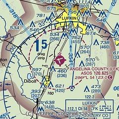
|
| Airport distance calculator |
|---|
|
|
| Sunrise and sunset |
|---|
|
Times for 15-Jul-2026
| | Local
(UTC-5) | | Zulu
(UTC) |
|---|
| Morning civil twilight | | 05:59 | | 10:59 |
| Sunrise | | 06:26 | | 11:26 |
| Sunset | | 20:24 | | 01:24 |
| Evening civil twilight | | 20:51 | | 01:51 |
|
| Current date and time |
|---|
| Zulu (UTC) | 15-Jul-2026 11:10:27 |
|---|
| Local (UTC-5) | 15-Jul-2026 06:10:27 |
|---|
|
| METAR |
|---|
| KLFK | 151053Z AUTO 16005KT 10SM BKN120 22/21 A3009 RMK AO2 SLP184 T02220211 $
|
|
| TAF |
|---|
| KLFK | 150545Z 1506/1606 VRB03KT P6SM OVC110 FM151500 VRB04KT P6SM BKN035 BKN120 BKN250 FM151900 20009KT P6SM VCTS BKN050CB BKN100 BKN250 FM160300 14003KT P6SM SCT100 BKN250
|
|
| NOTAMs |
|---|
NOTAMs are issued by the DoD/FAA and will open in a separate window not controlled by AirNav.
|
|


