FAA INFORMATION EFFECTIVE 15 MAY 2025
Location
| FAA Identifier: | MEJ |
| Lat/Long: | 37-16-43.2302N 100-21-23.2404W
37-16.720503N 100-21.387340W
37.2786751,-100.3564557
(estimated) |
| Elevation: | 2527 ft. / 770.2 m (surveyed) |
| Variation: | 08E (2000) |
| From city: | 1 mile W of MEADE, KS |
| Time zone: | UTC -5 (UTC -6 during Standard Time) |
| Zip code: | 67864 |
Airport Operations
| Airport use: | Open to the public |
| Activation date: | 06/1948 |
| Control tower: | no |
| ARTCC: | KANSAS CITY CENTER |
| FSS: | WICHITA FLIGHT SERVICE STATION |
| NOTAMs facility: | ICT (NOTAM-D service available) |
| Attendance: | MON-FRI 0800-1700 |
| Wind indicator: | lighted |
| Segmented circle: | yes |
| Lights: | ACTVT REIL RWY 17 & 35; PAPI RWY 17 & 35; MIRL RWY 17/35 - CTAF. |
| Beacon: | white-green (lighted land airport)
Operates sunset to sunrise. |
Airport Communications
| CTAF/UNICOM: | 122.8 |
| WX AWOS-3PT: | 119.425 (620-518-2544) |
- APCH/DEP CTL SVC PRVDD BY KANSAS CITY ARTCC (ZKC) ON FREQS 134.0/257.625 (LIBERAL RCAG).
Nearby radio navigation aids
| VOR radial/distance | | VOR name | | Freq | | Var |
|---|
| DDCr198/38.2 | | DODGE CITY VORTAC | | 108.20 | | 08E |
Airport Services
| Fuel available: | 100LL
100LL:24 HR SELF SVC. |
| Parking: | hangars and tiedowns |
| Airframe service: | MAJOR |
| Powerplant service: | MAJOR |
| Bottled oxygen: | NONE |
| Bulk oxygen: | NONE |
Runway Information
Runway 17/35
| Dimensions: | 4800 x 75 ft. / 1463 x 23 m |
| Surface: | concrete, in fair condition |
| Weight bearing capacity: | |
| Runway edge lights: | medium intensity |
| RUNWAY 17 | | RUNWAY 35 |
| Latitude: | 37-17.032073N | | 37-16.242767N |
| Longitude: | 100-21.376605W | | 100-21.313772W |
| Elevation: | 2518.1 ft. | | 2503.5 ft. |
| Traffic pattern: | left | | left |
| Runway heading: | 168 magnetic, 176 true | | 348 magnetic, 356 true |
| Markings: | nonprecision, in good condition | | nonprecision, in good condition |
| Visual slope indicator: | 2-light PAPI on left (3.00 degrees glide path) | | 2-light PAPI on left (3.00 degrees glide path) |
| Runway end identifier lights: | yes | | yes |
| Touchdown point: | yes, no lights | | yes, no lights |
| Obstructions: | 10 ft. road, 575 ft. from runway, 37:1 slope to clear | | 10 ft. road, 500 ft. from runway, 30:1 slope to clear |
Runway 8/26
| Dimensions: | 2085 x 85 ft. / 636 x 26 m |
| Surface: | turf, in good condition |
| RUNWAY 8 | | RUNWAY 26 |
| Latitude: | 37-16.910947N | | 37-16.912768N |
| Longitude: | 100-21.699352W | | 100-21.269410W |
| Elevation: | 2527.0 ft. | | 2510.7 ft. |
| Traffic pattern: | left | | left |
| Runway heading: | 082 magnetic, 090 true | | 262 magnetic, 270 true |
| Markings: | none, in good condition | | none, in good condition |
| Touchdown point: | yes, no lights | | yes, no lights |
| Obstructions: | 17 ft. road, 284 ft. from runway, 16:1 slope to clear | | none |
Airport Ownership and Management from official FAA records
| Ownership: | Publicly-owned |
| Owner: | CITY OF MEADE
PO BOX 338
MEADE, KS 67864
Phone 620-873-2091
CITY ADMINISTRATOR/AIRPORT MGR. |
| Manager: | DEAN CORDES
PO BOX 338
MEADE, KS 67864
Phone 620-873-2091
CRAIG STRATTON, BRINGHAM FLYING SVC-FBO 620-873-5191. |
Additional Remarks
| - | TWY 'B' CLSD PERMLY. |
| - | FOR CD CTC KANSAS CITY ARTCC AT 913-254-8508. |
Instrument Procedures
NOTE: All procedures below are presented as PDF files. If you need a reader for these files, you should download the free Adobe Reader.NOT FOR NAVIGATION. Please procure official charts for flight.
FAA instrument procedures published for use from 15 May 2025 at 0901Z to 13 June 2025 at 0900z.
IAPs - Instrument Approach Procedures |
|---|
| RNAV (GPS) RWY 17 | |
download (181KB) |
| RNAV (GPS) RWY 35 | |
download (190KB) |
| NOTE: Special Take-Off Minimums/Departure Procedures apply | |
download (147KB) |
Other nearby airports with instrument procedures:
KLBL - Liberal Mid-America Regional Airport (32 nm SW)
KDDC - Dodge City Regional Airport (35 nm NE)
KGCK - Garden City Regional Airport (43 nm NW)
KBFK - Buffalo Municipal Airport (43 nm SE)
K79 - Jetmore Municipal Airport (48 nm NE)
|
|

Road maps at:
MapQuest
Bing
Google
| Aerial photo |
|---|
WARNING: Photo may not be current or correct
 Photo by Von Rothenberge
Photo taken 14-Aug-2010
looking north.
Photo by Von Rothenberge
Photo taken 14-Aug-2010
looking north.
Do you have a better or more recent aerial photo of Meade Municipal Airport that you would like to share? If so, please send us your photo.
|
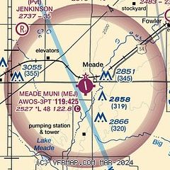
| Sectional chart |
|---|
|
| Airport distance calculator |
|---|
|
|
| Sunrise and sunset |
|---|
|
Times for 27-May-2025
| | Local
(UTC-5) | | Zulu
(UTC) |
|---|
| Morning civil twilight | | 05:56 | | 10:56 |
| Sunrise | | 06:26 | | 11:26 |
| Sunset | | 20:51 | | 01:51 |
| Evening civil twilight | | 21:22 | | 02:22 |
|
| Current date and time |
|---|
| Zulu (UTC) | 27-May-2025 20:26:14 |
|---|
| Local (UTC-5) | 27-May-2025 15:26:14 |
|---|
|
| METAR |
|---|
K19S
26nm NW | 272015Z AUTO 00000KT 10SM SCT019 BKN027 OVC036 17/12 A3018 RMK AO2 T01670122
|
KLBL
33nm SW | 272020Z AUTO 04006KT 10SM BKN029 OVC040 18/12 A3017 RMK AO2 PNO $
|
KDDC
35nm NE | 271952Z AUTO 03008KT 7SM BKN024 OVC032 17/12 A3017 RMK AO2 SLP205 T01720122
|
KGCK
42nm NW | 271954Z 14005KT 10SM SCT019 OVC038 16/12 A3017 RMK AO2 SLP204 T01560117
|
KHQG
49nm W | 272015Z AUTO 07005KT 10SM BKN047 19/12 A3016 RMK AO2
|
|
| TAF |
|---|
KLBL
33nm SW | 271720Z 2718/2818 36007KT P6SM SCT013 OVC035 FM272000 11005KT P6SM BKN035 FM280800 12009KT 1 1/2SM BR BKN007 PROB30 2809/2813 3/4SM -SHRA OVC004 FM281500 14008KT 5SM BR OVC005
|
KDDC
35nm NE | 271720Z 2718/2818 02006KT P6SM BKN012 OVC020 FM272300 07005KT P6SM BKN035 FM280700 13005KT 2SM BR BKN003 PROB30 2809/2814 1/2SM -TSRA BR OVC001CB FM281400 14006KT 2SM BR VCSH OVC004
|
|
| NOTAMs |
|---|
NOTAMs are issued by the DoD/FAA and will open in a separate window not controlled by AirNav.
|
|


