FAA INFORMATION EFFECTIVE 25 DECEMBER 2025
Location
| FAA Identifier: | MHT |
| Lat/Long: | 42-55-58.1000N 071-26-08.7000W
42-55.968333N 071-26.145000W
42.9328056,-71.4357500
(estimated) |
| Elevation: | 266.4 ft. / 81.2 m (surveyed) |
| Variation: | 15W (2020) |
| From city: | 3 miles S of MANCHESTER, NH |
| Time zone: | UTC -5 (UTC -4 during Daylight Saving Time) |
| Zip code: | 03103 |
Airport Operations
| Airport use: | Open to the public |
| Activation date: | 09/1943 |
| Control tower: | yes |
| ARTCC: | BOSTON CENTER |
| FSS: | BANGOR FLIGHT SERVICE STATION |
| NOTAMs facility: | MHT (NOTAM-D service available) |
| Attendance: | CONTINUOUS |
| Wind indicator: | lighted |
| Segmented circle: | no |
| Lights: | SS-SR |
| Beacon: | white-green (lighted land airport)
Operates sunset to sunrise. |
| Landing fee: | yes |
| Fire and rescue: | ARFF index C |
| International operations: | US CUSTOMS USER FEE ARPT. |
Airport Communications
| UNICOM: | 122.95 |
| ATIS: | 119.55 |
| WX ASOS: | 119.55 (603-626-6902) |
| MANCHESTER GROUND: | 121.9 |
| MANCHESTER TOWER: | 121.3 239.025 |
| BOSTON APPROACH: | 124.9 |
| BOSTON DEPARTURE: | 124.9 |
| CLEARANCE DELIVERY: | 135.9 |
| CLASS C: | 124.9 ;MANCHESTER/CONCORD AREA 125.05 ;NH SEACOAST AREA 134.75 ;NH LAKES REGION |
| EMERG: | 121.5 243.0 |
| WX AWOS-3PT at ASH (10 nm S): | 125.1 (603-578-0473) |
| WX ASOS at CON (16 nm N): | 132.325 (603-451-1106) |
| WX ASOS at LWM (19 nm SE): | PHONE 978-687-8017 |
- NOTE: FREQS 124.9 AND 305.4 ARE PHYSICALLY LCTD IN THE BOSTON ARTCC; FREQ 127.75 IS LCTD AT THE RADAR SITE AT NASHUA, NH.
- SAID IN USE. OPERATE TRANSPONDERS WITH ALTITUDE REPORTING MODE AND ADS-B (IF EQUIPPED) ENABLED ON ALL AIRPORT SURFACES.
Nearby radio navigation aids
| VOR radial/distance | | VOR name | | Freq | | Var |
|---|
| CONr175/18.3 | | CONCORD VOR/DME | | 112.90 | | 15W |
| GDMr064/35.9 | | GARDNER VOR/DME | | 116.95 | | 14W |
| BOSr346/39.7 | | BOSTON VOR/DME | | 112.70 | | 16W |
| NDB name | | Hdg/Dist | | Freq | | Var | | ID |
|---|
| FITZY | | 060/5.8 | | 209 | | 15W | | MJ | -- .--- |
| EPSOM | | 192/11.2 | | 216 | | 16W | | CO | -.-. --- |
| ROLLINS | | 253/31.7 | | 260 | | 16W | | ESG | . ... --. |
Airport Services
| Fuel available: | 100LL JET-A |
| Parking: | hangars and tiedowns |
| Airframe service: | MAJOR |
| Powerplant service: | MAJOR |
| Bottled oxygen: | HIGH |
| Bulk oxygen: | NONE |
Runway Information
Runway 17/35
| Dimensions: | 9250 x 150 ft. / 2819 x 46 m |
| Surface: | asphalt/grooved, in fair condition |
| Weight bearing capacity: | | Single wheel: | 200.0 | | Double wheel: | 300.0 | | Double tandem: | 350.0 |
|
| Runway edge lights: | high intensity |
| RUNWAY 17 | | RUNWAY 35 |
| Latitude: | 42-56.505947N | | 42-55.109308N |
| Longitude: | 071-26.374118W | | 071-25.548638W |
| Elevation: | 216.1 ft. | | 266.4 ft. |
| Traffic pattern: | left | | left |
| Runway heading: | 172 magnetic, 157 true | | 352 magnetic, 337 true |
| Displaced threshold: | 336 ft. | | 850 ft. |
| Declared distances: | TORA:9250 TODA:9250 ASDA:9250 LDA:8914 | | TORA:9250 TODA:9250 ASDA:8500 LDA:7650 |
| Markings: | precision, in good condition | | precision, in good condition |
| Visual slope indicator: | 4-light PAPI on right (3.10 degrees glide path) | | 4-light PAPI on left (3.00 degrees glide path) |
| RVR equipment: | touchdown, midfield, rollout | | touchdown, midfield, rollout |
| Approach lights: | MALSR: 1,400 foot medium intensity approach lighting system with runway alignment indicator lights | | ALSF2: standard 2,400 foot high intensity approach lighting system with centerline sequenced flashers (category II or III) |
| Runway end identifier lights: | no | | no |
| Centerline lights: | yes | | yes |
| Touchdown point: | yes, lighted | | yes, lighted |
| Instrument approach: | ILS/DME | | ILS/DME |
| Obstructions: | 71 ft. pole, 2600 ft. from runway, 125 ft. left of centerline, 34:1 slope to clear | | 53 ft. bldg, 3025 ft. from runway, 75 ft. right of centerline |
Runway 6/24
| Dimensions: | 7651 x 150 ft. / 2332 x 46 m |
| Surface: | asphalt/grooved, in fair condition |
| Weight bearing capacity: | | Single wheel: | 200.0 | | Double wheel: | 300.0 | | Double tandem: | 350.0 |
|
| Runway edge lights: | high intensity |
| RUNWAY 6 | | RUNWAY 24 |
| Latitude: | 42-55.697483N | | 42-56.627172N |
| Longitude: | 071-26.943640W | | 071-25.787302W |
| Elevation: | 220.9 ft. | | 241.5 ft. |
| Traffic pattern: | left | | left |
| Runway heading: | 057 magnetic, 042 true | | 237 magnetic, 222 true |
| Displaced threshold: | 442 ft. | | no |
| Declared distances: | TORA:7650 TODA:7650 ASDA:7650 LDA:7208 | | TORA:7650 TODA:7650 ASDA:6850 LDA:6850 |
| Markings: | precision, in good condition | | nonprecision, in good condition |
| Visual slope indicator: | 4-light PAPI on left (3.00 degrees glide path)
PAPI UNUSBL BYD 6 DEGS R OF CNTRLN. | | 4-light PAPI on left (3.00 degrees glide path) |
| RVR equipment: | touchdown, rollout | | touchdown, rollout |
| Runway end identifier lights: | yes | | yes |
| Centerline lights: | yes | | yes |
| Touchdown point: | yes, no lights | | yes, no lights |
| Instrument approach: | ILS | | |
| Obstructions: | 61 ft. trees, 2667 ft. from runway, 470 ft. left of centerline, 40:1 slope to clear | | 52 ft. trees, 1500 ft. from runway, 75 ft. left of centerline, 25:1 slope to clear |
Airport Ownership and Management from official FAA records
| Ownership: | Publicly-owned |
| Owner: | CITY OF MANCHESTER
CITY HALL
MANCHESTER, NH 03101
Phone 603-624-6539 |
| Manager: | THOMAS J. MALAFRONTE
1 AIRPORT RD SUITE 300
MANCHESTER, NH 03103
Phone 603-624-6539 |
Additional Remarks
| A39-06/24 | PCR VALUE: 700/F/C/X/T |
| A39-17/35 | PCR VALUE: 700/F/C/X/T |
| E60-06 | ENGINEERED MATERIALS ARRESTING SYSTEM (EMAS) 300 FT IN LENGTH BY 170 FT IN WIDTH LCTD AT THE DER 06. |
| - | AIR CARRIER ACFT ONLY PERMITTED TO OPR ON AIRLINE TERMINAL RAMP. |
| - | JET ACFT TAXIING WB ACRS RWY 17/35 AT TWY E MUST USE CTN & LOW SETTINGS DUE TO LGT ACFT PRKG ON E RAMP. |
| - | NO TAXIING BTWN PUSHED BACK ACFT & THE AIRLINE TERMINAL OR CARGO RAMPS. |
| - | AIR CARRIERS EXCLUDED FM OPERATING ON TWY L. |
| - | TWY A SAFETY AREA S OF TWY E TO TWY A2 IS 65 FT. |
| - | ACFT WITH WINGSPAN GREATER THAN 145 FT RSTRD FM TWY G AND TWY N. |
| - | AMMON RAMP RSTRD TO ACFT WITH WINGSPAN LESS THAN 118 FT. ACFT ARE REQ TO MNTN TAXILANE CNTRLN TO AVOID PARKED GA ACFT TIEDOWNS. ACFT WITH WINGSPAN 118 FT OR GTR REQ GND CREW ASSISTANCE FOR TAXI & PRKG. |
| - | NO TGLS PERMITTED DURG SNOW REMOVAL OPNS. |
| - | NOISE ABATEMENT PROCEDURES: TURBOJET ACFT SHOULD EXPECT A RIGHT TURN WHEN DEPARTING RY 17. |
| - | ACFT NOT PERMITTED TO TAXI BETWEEN AIRLINE TERMINAL BLDG & ACFT THAT HAVE PUSHED BACK OR ARE TAXIING ON TWY G OR N. |
Instrument Procedures
NOTE: All procedures below are presented as PDF files. If you need a reader for these files, you should download the free Adobe Reader.NOT FOR NAVIGATION. Please procure official charts for flight.
FAA instrument procedures published for use from 25 December 2025 at 0901z to 22 January 2026 at 0900z.
STARs - Standard Terminal Arrivals |
|---|
| ROZZE TWO (RNAV) | |
2 pages:
[1] [2] (347KB) |
IAPs - Instrument Approach Procedures |
|---|
| ILS OR LOC RWY 06 | |
download (246KB) |
| ILS OR LOC RWY 17 | |
download (243KB) |
| ILS OR LOC RWY 35 | |
download (249KB) |
| ILS RWY 35 (SA CAT I) | |
download (239KB) |
| ILS RWY 35 (CAT II - III) | |
download (235KB) |
| RNAV (RNP) Z RWY 17 | |
download (230KB) |
| RNAV (RNP) Z RWY 35 | |
download (232KB) |
| RNAV (GPS) RWY 06 | |
download (259KB) |
| RNAV (GPS) RWY 24 | |
download (219KB) |
| RNAV (GPS) Y RWY 17 | |
download (222KB) |
| RNAV (GPS) Y RWY 35 | |
download (321KB) |
| NOTE: Special Alternate Minimums apply | |
download (129KB) |
Departure Procedures |
|---|
| MANCHESTER ONE | |
download (213KB) |
| PPORT FOUR (RNAV) | |
download (221KB) |
| NOTE: Special Take-Off Minimums/Departure Procedures apply | |
download (488KB) |
Other nearby airports with instrument procedures:
KASH - Boire Field Airport (10 nm S)
KCON - Concord Municipal Airport (16 nm N)
KLWM - Lawrence Municipal Airport (19 nm SE)
KAFN - Jaffrey Airfield Silver Ranch (26 nm W)
KFIT - Fitchburg Municipal Airport (27 nm SW)
|
|

Road maps at:
MapQuest
Bing
Google
| Aerial photo |
|---|
WARNING: Photo may not be current or correct
 Photo by Nick Tognacci
Photo taken 30-Nov-2014
at 16,000 feet, in a PC12, while looking north.
Photo by Nick Tognacci
Photo taken 30-Nov-2014
at 16,000 feet, in a PC12, while looking north.
Do you have a better or more recent aerial photo of Manchester Boston Regional Airport that you would like to share? If so, please send us your photo.
|
| Sectional chart |
|---|
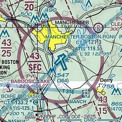
|
CAUTION: Diagram may not be current
 Download PDF
of official airport diagram from the FAA
| Airport distance calculator |
|---|
|
|
| Sunrise and sunset |
|---|
|
Times for 13-Jan-2026
| | Local
(UTC-5) | | Zulu
(UTC) |
|---|
| Morning civil twilight | | 06:44 | | 11:44 |
| Sunrise | | 07:16 | | 12:16 |
| Sunset | | 16:33 | | 21:33 |
| Evening civil twilight | | 17:05 | | 22:05 |
|
| Current date and time |
|---|
| Zulu (UTC) | 13-Jan-2026 16:40:28 |
|---|
| Local (UTC-5) | 13-Jan-2026 11:40:28 |
|---|
|
| METAR |
|---|
| KMHT | 131553Z VRB04KT 10SM CLR 03/M05 A2998 RMK AO2 SLP169 T00331050
|
KASH
11nm S | 131556Z VRB04KT 10SM CLR 03/M05 A2999 RMK AO2 SLP158 T00331050
|
KCON
16nm N | 131551Z AUTO 24005KT 10SM CLR 04/M04 A2997 RMK AO2 SLP154 T00391039 $
|
KLWM
19nm SE | 131554Z 23008KT 10SM CLR 04/M04 A3001 RMK AO2 SLP163 T00391044
|
|
| TAF |
|---|
| KMHT | 131134Z 1312/1412 22009KT P6SM SCT250 FM132100 17009KT P6SM BKN100
|
KCON
16nm N | 131134Z 1312/1412 23009KT P6SM SCT250 FM132100 18009KT P6SM BKN100
|
|
| NOTAMs |
|---|
NOTAMs are issued by the DoD/FAA and will open in a separate window not controlled by AirNav.
|
|


