FAA INFORMATION EFFECTIVE 09 JULY 2026
Location
| FAA Identifier: | MTJ |
| Lat/Long: | 38-30-35.3000N 107-53-39.3000W
38-30.588333N 107-53.655000W
38.5098056,-107.8942500
(estimated) |
| Elevation: | 5758.5 ft. / 1755.2 m (surveyed) |
| Variation: | 12E (1995) |
| From city: | 1 mile NW of MONTROSE, CO |
| Time zone: | UTC -6 (UTC -7 during Standard Time) |
| Zip code: | 81401 |
Airport Operations
| Airport use: | Open to the public |
| Activation date: | 09/1946 |
| Control tower: | no |
| ARTCC: | DENVER CENTER |
| FSS: | DENVER FLIGHT SERVICE STATION |
| NOTAMs facility: | MTJ (NOTAM-D service available) |
| Attendance: | DEC16-MAR31 0500-2100, APR1-DEC15 0530-2100 |
| Wind indicator: | lighted |
| Segmented circle: | yes |
| Lights: | ACTVT MALSR RWY 17; REIL RWY 31 & 35; HIRL RWY 13/31 & 17/35 - CTAF. |
| Beacon: | white-green (lighted land airport)
Operates sunset to sunrise. |
| Fire and rescue: | ARFF index B |
| Airline operations: | UNSKED ACR OPS MORE THAN 30 PAX SEATS 24 HR PPR - AMGR. |
Airport Communications
| CTAF/UNICOM: | 122.8 |
| WX ASOS: | 135.225 (970-249-1534) |
| WX AWOS-3 at AJZ (18 nm NW): | 134.0 (970-874-3251) |
- APCH/DEP CTLSVC PRVDD BY DENVER ARTCC (ZDV) ON 127.1(GRAND MESA/A/ RCAG & MONTROSE RCAG) 343.65 (MESA/A RCAG).
Nearby radio navigation aids
| VOR radial/distance | | VOR name | | Freq | | Var |
|---|
| MTJ at field | | MONTROSE VOR/DME | | 117.10 | | 12E |
| ETLr019/33.0 | | CONES VOR/DME | | 116.95 | | 12E |
Airport Services
| Fuel available: | 100LL JET-A+ |
| Parking: | hangars and tiedowns |
| Airframe service: | MAJOR |
| Powerplant service: | MAJOR |
| Bottled oxygen: | HIGH |
| Bulk oxygen: | HIGH |
Runway Information
Runway 17/35
| Dimensions: | 10000 x 150 ft. / 3048 x 46 m |
| Surface: | asphalt/grooved, in good condition |
| Weight bearing capacity: | | Single wheel: | 75.0 | | Double wheel: | 190.0 | | Double tandem: | 265.0 |
|
| Runway edge lights: | high intensity |
| Operational restrictions: | RCMDD FOR APCH SPD MORE THAN 121 KT. |
| RUNWAY 17 | | RUNWAY 35 |
| Latitude: | 38-31.789898N | | 38-30.142865N |
| Longitude: | 107-53.564392W | | 107-53.557750W |
| Elevation: | 5693.7 ft. | | 5734.1 ft. |
| Traffic pattern: | left | | left |
| Runway heading: | 168 magnetic, 180 true | | 348 magnetic, 360 true |
| Declared distances: | TORA:10000 TODA:10000 ASDA:10000 LDA:10000 | | TORA:10000 TODA:10000 ASDA:10000 LDA:10000 |
| Markings: | precision, in good condition | | precision, in good condition |
| Visual slope indicator: | 4-light PAPI on left (3.00 degrees glide path) | | 4-light PAPI on left (3.00 degrees glide path) |
| Approach lights: | MALSR: 1,400 foot medium intensity approach lighting system with runway alignment indicator lights | | |
| Runway end identifier lights: | no | | yes |
| Touchdown point: | yes, no lights | | yes, no lights |
| Instrument approach: | LOC/GS | | |
Runway 13/31
| Dimensions: | 7510 x 100 ft. / 2289 x 30 m |
| Surface: | asphalt/grooved, in good condition |
| Weight bearing capacity: | | Single wheel: | 65.0 | | Double wheel: | 90.0 | | Double tandem: | 150.0 |
|
| Runway edge lights: | high intensity |
| Operational restrictions: | RCMDD FOR APCH SPD LESS THAN 121 KT. |
| RUNWAY 13 | | RUNWAY 31 |
| Latitude: | 38-30.553458N | | 38-29.614005N |
| Longitude: | 107-54.291427W | | 107-53.267497W |
| Elevation: | 5698.5 ft. | | 5758.5 ft. |
| Traffic pattern: | left | | left |
| Runway heading: | 127 magnetic, 139 true | | 307 magnetic, 319 true |
| Declared distances: | TORA:7510 TODA:7510 ASDA:7510 LDA:7510 | | TORA:7510 TODA:7510 ASDA:7510 LDA:7510 |
| Markings: | nonprecision, in good condition | | nonprecision, in good condition |
| Visual slope indicator: | 4-box VASI on left (3.00 degrees glide path) | | 4-box VASI on left (3.00 degrees glide path) |
| Runway end identifier lights: | no | | yes |
| Touchdown point: | yes, no lights | | yes, no lights |
| Obstructions: | 41 ft. tree, 2050 ft. from runway, 575 ft. right of centerline, 45:1 slope to clear
THREE MKD & LGTD POLES 1.5 MI NW RWY END. | | none |
Airport Ownership and Management from official FAA records
| Ownership: | Publicly-owned |
| Owner: | MONTROSE COUNTY
161 S. TOWNSEND
MONTROSE, CO 81401
Phone 970-249-7755 |
| Manager: | LLOYD ARNOLD
2100 AIRPORT ROAD
MONTROSE, CO 81401
Phone 970-249-3433
970-249-3203 EXT 5811. |
Additional Remarks
| A39-13/31 | PCR VALUE: 290/F/D/X/T |
| A39-17/35 | PCR VALUE: 770/F/D/X/T |
| A30A-35 | PREFERRED TKOF RWY. |
| A30A-13 | PREFERRED LNDG RWY. |
| A30A-31 | PREFERRED TKOF RWY. |
| A30A-17 | PREFERRED LNDG RWY. |
| - | FOR CD, IFUN TO CTC ON DENVER ARTCC APP/DEP CTL FREQ, CTC DENVER ARTCC AT 303-651-4257. |
| - | BIRDS & WILDLIFE ON & INVOF ARPT. |
| - | ACR ACES TRML RAMP VIA TWY C; OUBD TFC TWY D. |
| - | RAMP CNCTR ADJ TO T HNGR ROW CLSD INDEF; TWY E & E6 CLSD EXC WINGSPAN LESS THAN 78 FT. |
| - | TWY B LTD TO SNGL WHEEL MAX 80000 LB; DBL WHEEL MAX 105000 LB; DBL TAND WHEEL MAX 170000 LB. |
Instrument Procedures
NOTE: All procedures below are presented as PDF files. If you need a reader for these files, you should download the free Adobe Reader.NOT FOR NAVIGATION. Please procure official charts for flight.
FAA instrument procedures published for use from 09 July 2026 at 0901Z to 06 August 2026 at 0900Z.
IAPs - Instrument Approach Procedures |
|---|
| ILS OR LOC RWY 17 | |
download (371KB) |
| RNAV (GPS) RWY 13 | |
download (315KB) |
| RNAV (GPS) RWY 17 | |
download (330KB) |
| RNAV (GPS) RWY 35 | |
download (464KB) |
| VOR RWY 13 | |
download (328KB) |
| NOTE: Special Alternate Minimums apply | |
download (144KB) |
Departure Procedures |
|---|
| BLUE MESA THREE | |
download (172KB) |
| BRICK FOUR | |
download (152KB) |
|
|---|
| MONTROSE TWO (OBSTACLE) | |
download (283KB) |
| NOTE: Special Take-Off Minimums/Departure Procedures apply | |
download (105KB) |
Other nearby airports with instrument procedures:
KAJZ - Blake Field Airport (18 nm NW)
KTEX - Telluride Regional Airport (33 nm S)
KAIB - Hopkins Field Airport (35 nm SW)
KGUC - Gunnison-Crested Butte Regional Airport (45 nm E)
KGJT - Grand Junction Regional Airport (47 nm NW)
|
|

Road maps at:
MapQuest
Bing
Google
| Aerial photo |
|---|
WARNING: Photo may not be current or correct

Do you have a better or more recent aerial photo of Montrose Regional Airport that you would like to share? If so, please send us your photo.
|
| Sectional chart |
|---|
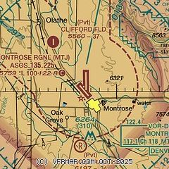
|
| Airport distance calculator |
|---|
|
|
| Sunrise and sunset |
|---|
|
Times for 13-Jul-2026
| | Local
(UTC-6) | | Zulu
(UTC) |
|---|
| Morning civil twilight | | 05:28 | | 11:28 |
| Sunrise | | 05:59 | | 11:59 |
| Sunset | | 20:35 | | 02:35 |
| Evening civil twilight | | 21:06 | | 03:06 |
|
| Current date and time |
|---|
| Zulu (UTC) | 14-Jul-2026 02:26:20 |
|---|
| Local (UTC-6) | 13-Jul-2026 20:26:20 |
|---|
|
| METAR |
|---|
| KMTJ | 140153Z AUTO 23009G16KT 10SM FEW120 28/08 A3020 RMK AO2 RAE20 SLP127 P0000 T02830083
|
KAJZ
18nm NW | 140215Z AUTO 17011G15KT 10SM CLR 32/07 A3013 RMK AO2 T03180072
|
|
| TAF |
|---|
| KMTJ | 131720Z 1318/1418 34007KT P6SM SCT120 FM140000 14007KT P6SM SCT120
|
|
| NOTAMs |
|---|
NOTAMs are issued by the DoD/FAA and will open in a separate window not controlled by AirNav.
|
|


