FAA INFORMATION EFFECTIVE 30 OCTOBER 2025
Location
| FAA Identifier: | OWP |
| Lat/Long: | 36-10-31.0000N 096-09-06.6000W
36-10.516667N 096-09.110000W
36.1752778,-96.1518333
(estimated) |
| Elevation: | 892.2 ft. / 271.9 m (surveyed) |
| Variation: | 02E (2025) |
| From city: | 3 miles NW of SAND SPRINGS, OK |
| Time zone: | UTC -6 (UTC -5 during Daylight Saving Time) |
| Zip code: | 74063 |
Airport Operations
| Airport use: | Open to the public |
| Activation date: | 06/1970 |
| Control tower: | no |
| ARTCC: | KANSAS CITY CENTER |
| FSS: | MC ALESTER FLIGHT SERVICE STATION |
| NOTAMs facility: | MLC (NOTAM-D service available) |
| Attendance: | MON-SAT 0800-1700, ALL SUN 1000-1700
ARPT UNATENDED THANKSGIVING, CHRISTMAS & NEW YEAR'S DAY. FOR ASSISTANCE AND FOR ARPT ATTENDANT AFT HRS CALL 918-638-6895. |
| Wind indicator: | lighted |
| Segmented circle: | yes |
| Lights: | ACTVT ODALS RWY 35; MIRL RWY 17/35 - CTAF. PAPI RWY 17 & 35 ON CONSLY. |
| Beacon: | white-green (lighted land airport)
Operates sunset to sunrise. |
Airport Communications
| CTAF/UNICOM: | 122.7 |
| WX AWOS-3T: | 118.325 (918-246-2635) |
| TULSA APPROACH: | 124.0 |
| TULSA DEPARTURE: | 124.0 |
| WX ASOS at RVS (11 nm SE): | 126.5 (918-299-0740) |
| WX ASOS at TUL (13 nm E): | PHONE 539-399-0187 |
Nearby radio navigation aids
| VOR radial/distance | | VOR name | | Freq | | Var |
|---|
| TULr258/17.7 | | TULSA VORTAC | | 114.40 | | 08E |
| OKMr326/32.1 | | OKMULGEE VOR/DME | | 114.90 | | 08E |
| NDB name | | Hdg/Dist | | Freq | | Var | | ID |
|---|
| OILLR | | 287/13.6 | | 338 | | 03E | | TU | - ..- |
Airport Services
| Fuel available: | 100LL
100LL:FUEL AVBL 24 HRS WITH MAJOR CREDIT CARD. |
| Parking: | tiedowns |
| Airframe service: | NONE |
| Powerplant service: | NONE |
| Bottled oxygen: | NONE |
| Bulk oxygen: | NONE |
Runway Information
Runway 17/35
| Dimensions: | 5799 x 100 ft. / 1768 x 30 m |
| Surface: | asphalt, in good condition |
| Weight bearing capacity: | | Single wheel: | 30.0 | | Double wheel: | 58.0 |
|
| Runway edge lights: | medium intensity |
| RUNWAY 17 | | RUNWAY 35 |
| Latitude: | 36-10.992920N | | 36-10.040312N |
| Longitude: | 096-09.157657W | | 096-09.063043W |
| Elevation: | 889.0 ft. | | 890.1 ft. |
| Traffic pattern: | left
RIGHT TFC FOR HELIS. | | left |
| Runway heading: | 173 magnetic, 175 true | | 353 magnetic, 355 true |
| Markings: | nonprecision, in good condition | | nonprecision, in good condition |
| Visual slope indicator: | 4-light PAPI on left (3.00 degrees glide path) | | 4-light PAPI on left (3.00 degrees glide path)
PAPI UNUSBL BYD 8 DEGS LEFT, RIGHT OF RCL. |
| Approach lights: | | | ODALS: omnidirectional approach lighting system |
| Runway end identifier lights: | | | no |
| Touchdown point: | yes, no lights | | yes, no lights |
| Obstructions: | 14 ft. trees, 566 ft. from runway, 264 ft. left of centerline, 26:1 slope to clear | | none |
Airport Ownership and Management from official FAA records
| Ownership: | Publicly-owned |
| Owner: | CITY OF SAND SPRINGS
CITY HALL, 100 E. BROADWAY
SAND SPRINGS, OK 74063
Phone 918-246-2500 |
| Manager: | KEN MADISON
3200 N AIRPORT RD
SAND SPRINGS, OK 74063
Phone 918-246-2605
AFT HRS OR EMER: 918-638-6895. |
Additional Remarks
| - | DEER INVOF ARPT. |
| - | HELICOPTER TRNG WEST TWY & WEST RAMP. |
| - | FOR CD CTC TULSA APCH AT 918-831-6714/6720. |
Instrument Procedures
NOTE: All procedures below are presented as PDF files. If you need a reader for these files, you should download the free Adobe Reader.NOT FOR NAVIGATION. Please procure official charts for flight.
FAA instrument procedures published for use from 30 October 2025 at 0901Z to 27 November 2025 at 0900Z.
IAPs - Instrument Approach Procedures |
|---|
| RNAV (GPS) RWY 17 | |
download (290KB) |
| RNAV (GPS) RWY 35 | |
download (288KB) |
| NOTE: Special Alternate Minimums apply | |
download (147KB) |
| NOTE: Special Alternate Minimums apply | |
download (147KB) |
| NOTE: Special Take-Off Minimums/Departure Procedures apply | |
download (394KB) |
Other nearby airports with instrument procedures:
KRVS - Tulsa Riverside Airport (11 nm SE)
KTUL - Tulsa International Airport (13 nm E)
3F7 - Jones Memorial Airport (26 nm SW)
KOKM - Okmulgee Regional Airport/Paul and Betty Abbott Field (32 nm S)
KCUH - Cushing Municipal Airport (33 nm SW)
|
|

Road maps at:
MapQuest
Bing
Google
| Aerial photo |
|---|
WARNING: Photo may not be current or correct
 Photo by Derrick Dunegan CFII
Photo taken 10-May-2018
looking northeast.
Photo by Derrick Dunegan CFII
Photo taken 10-May-2018
looking northeast.
Do you have a better or more recent aerial photo of William R Pogue Municipal Airport that you would like to share? If so, please send us your photo.
|
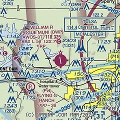
| Sectional chart |
|---|
|
CAUTION: Diagram may not be current

| Airport distance calculator |
|---|
|
|
| Sunrise and sunset |
|---|
|
Times for 06-Nov-2025
| | Local
(UTC-6) | | Zulu
(UTC) |
|---|
| Morning civil twilight | | 06:27 | | 12:27 |
| Sunrise | | 06:53 | | 12:53 |
| Sunset | | 17:23 | | 23:23 |
| Evening civil twilight | | 17:50 | | 23:50 |
|
| Current date and time |
|---|
| Zulu (UTC) | 06-Nov-2025 11:03:27 |
|---|
| Local (UTC-6) | 06-Nov-2025 05:03:27 |
|---|
|
| METAR |
|---|
| KOWP | 061055Z AUTO 00000KT 10SM BKN048 10/06 A3009 RMK AO2 T01000063
|
KRVS
11nm SE | 061053Z AUTO 02003KT 10SM OVC050 12/08 A3007 RMK AO2 SLP188 T01170083
|
KTUL
13nm E | 061053Z 33003KT 10SM BKN050 10/07 A3008 RMK AO2 SLP182 T01000072
|
|
| TAF |
|---|
KRVS
11nm SE | 060520Z 0606/0706 02004KT P6SM SKC WS002/02028KT FM061200 00000KT P6SM SCT020 FM061500 16005KT P6SM BKN030 FM061800 17010G21KT P6SM SCT040 FM062300 18008KT P6SM SCT250
|
KTUL
13nm E | 060520Z 0606/0706 36005KT P6SM SKC WS002/02028KT FM061200 12004KT P6SM SCT020 FM061500 16006KT P6SM BKN030 FM061800 16012G24KT P6SM SCT040 FM062300 17011KT P6SM SCT250
|
|
| NOTAMs |
|---|
NOTAMs are issued by the DoD/FAA and will open in a separate window not controlled by AirNav.
|
|


