FAA INFORMATION EFFECTIVE 27 NOVEMBER 2025
Location
| FAA Identifier: | PGR |
| Lat/Long: | 36-03-49.7000N 090-30-33.1000W
36-03.828333N 090-30.551667W
36.0638056,-90.5091944
(estimated) |
| Elevation: | 290.2 ft. / 88.5 m (surveyed) |
| Variation: | 01E (1995) |
| From city: | 1 mile NW of PARAGOULD, AR |
| Time zone: | UTC -6 (UTC -5 during Daylight Saving Time) |
| Zip code: | 72450 |
Airport Operations
| Airport use: | Open to the public |
| Activation date: | 07/1958 |
| Control tower: | no |
| ARTCC: | MEMPHIS CENTER |
| FSS: | JONESBORO FLIGHT SERVICE STATION |
| NOTAMs facility: | JBR (NOTAM-D service available) |
| Attendance: | MON-FRI 0700-1600
FOR SVC AFT HRS CALL 870-450-7599 FEE CHARGED. |
| Pattern altitude: | 1099.2 ft. MSL |
| Wind indicator: | lighted |
| Segmented circle: | yes |
| Lights: | ACTVT MIRL RY 04/22, REIL & PAPI RYS 04 & 22 - CTAF. |
| Beacon: | white-green (lighted land airport)
Operates sunset to sunrise. |
Airport Communications
| CTAF/UNICOM: | 122.8 |
| WX ASOS at JBR (15 nm SW): | 118.525 (870-932-4010) |
- APCH/DEP SVC PRVDD BY MEMPHIS ARTCC ON FREQS 120.075/289.4 (WALNUT RIDGE RCAG).
Nearby radio navigation aids
| VOR radial/distance | | VOR name | | Freq | | Var |
|---|
| JBRr019/12.0 | | JONESBORO VOR/DME | | 115.85 | | 00W |
| ARGr093/21.7 | | WALNUT RIDGE VORTAC | | 114.50 | | 04E |
Airport Services
| Fuel available: | 100LL JET-A
100LL:24 HR SELF SVC FUEL AVBL WITH CREDIT CARD (100LL & JET A) |
| Parking: | tiedowns |
| Bottled oxygen: | NONE |
| Bulk oxygen: | NONE |
Runway Information
Runway 4/22
| Dimensions: | 4500 x 75 ft. / 1372 x 23 m |
| Surface: | asphalt, in good condition |
| Weight bearing capacity: | |
| Runway edge lights: | medium intensity |
| RUNWAY 4 | | RUNWAY 22 |
| Latitude: | 36-03.518135N | | 36-04.029503N |
| Longitude: | 090-30.797417W | | 090-30.135667W |
| Elevation: | 289.6 ft. | | 285.0 ft. |
| Traffic pattern: | left | | left |
| Runway heading: | 045 magnetic, 046 true | | 225 magnetic, 226 true |
| Displaced threshold: | 489 ft. | | 148 ft. |
| Markings: | nonprecision, in fair condition | | nonprecision, in fair condition |
| Visual slope indicator: | 2-light PAPI on left (3.00 degrees glide path) | | 2-light PAPI on left (4.00 degrees glide path) |
| Runway end identifier lights: | yes | | yes |
| Touchdown point: | yes, no lights | | yes, no lights |
| Obstructions: | 28 ft. road, 180 ft. from runway
ROAD 180 FT & EXTENDS INTO RY PROTECTION ZONE. | | 13 ft. road, 460 ft. from runway, 200 ft. left of centerline, 20:1 slope to clear
OPEN DITCH 55 FT WIDE; 10 FT DEEP 138 FT FM THLD CROSSING. |
Runway 8/26
| Dimensions: | 2792 x 100 ft. / 851 x 30 m |
| Surface: | turf, in fair condition |
| Operational restrictions: | SOFT WHEN WET. |
| RUNWAY 8 | | RUNWAY 26 |
| Latitude: | 36-03.912450N | | 36-03.920783N |
| Longitude: | 090-30.973083W | | 090-30.406400W |
| Elevation: | 283.0 ft. | | 279.0 ft. |
| Traffic pattern: | left | | left |
| Runway heading: | 088 magnetic, 089 true | | 268 magnetic, 269 true |
| Markings: | NSTD, in good condition | | NSTD, in good condition |
| Touchdown point: | yes, no lights | | yes, no lights |
| Obstructions: | 40 ft. pline, 1300 ft. from runway, 50 ft. right of centerline, 32:1 slope to clear | | 40 ft. trees, 1750 ft. from runway, 43:1 slope to clear |
Airport Ownership and Management from official FAA records
| Ownership: | Publicly-owned |
| Owner: | CITY OF PARAGOULD
301 WEST COURT
PARAGOULD, AR 72450
Phone 870-239-7510 |
| Manager: | ROGER SLAYTON
305 AIRPORT ROAD
PARAGOULD, AR 72450
Phone 870-239-7505 |
Additional Remarks
| - | UNLGTD TOWER 250 FT AGL .17 MILES ESE AER 04. |
| - | WILDLIFE ON & INVOF OF RY AND TWY. |
| - | FOR CD CTC MEMPHIS ARTCC AT 901-368-8453/8449. |
Instrument Procedures
NOTE: All procedures below are presented as PDF files. If you need a reader for these files, you should download the free Adobe Reader.NOT FOR NAVIGATION. Please procure official charts for flight.
FAA instrument procedures published for use from 27 November 2025 at 0901Z to 25 December 2025 at 0900Z.
IAPs - Instrument Approach Procedures |
|---|
| RNAV (GPS) RWY 04 | |
download (201KB) |
| RNAV (GPS) RWY 22 | |
download (184KB) |
| VOR RWY 04 | |
download (219KB) |
| NOTE: Special Take-Off Minimums/Departure Procedures apply | |
download (379KB) |
Other nearby airports with instrument procedures:
KJBR - Jonesboro Municipal Airport (15 nm SW)
KMXA - Manila Municipal Airport (20 nm SE)
KARG - Walnut Ridge Regional Airport (20 nm W)
4M9 - Corning Municipal Airport (22 nm N)
M70 - Pocahontas Municipal Airport (24 nm NW)
|
|

Road maps at:
MapQuest
Bing
Google
| Aerial photo |
|---|
WARNING: Photo may not be current or correct
 Photo courtesy of the Arkansas Department of Aeronautics
Taken in the Spring of 2007
Photo courtesy of the Arkansas Department of Aeronautics
Taken in the Spring of 2007
Do you have a better or more recent aerial photo of Kirk Field Airport that you would like to share? If so, please send us your photo.
|
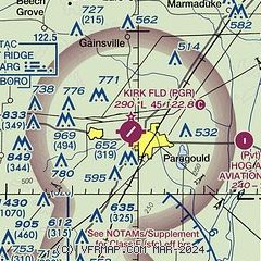
| Sectional chart |
|---|
|
| Airport distance calculator |
|---|
|
|
| Sunrise and sunset |
|---|
|
Times for 20-Dec-2025
| | Local
(UTC-6) | | Zulu
(UTC) |
|---|
| Morning civil twilight | | 06:41 | | 12:41 |
| Sunrise | | 07:10 | | 13:10 |
| Sunset | | 16:50 | | 22:50 |
| Evening civil twilight | | 17:18 | | 23:18 |
|
| Current date and time |
|---|
| Zulu (UTC) | 20-Dec-2025 22:20:55 |
|---|
| Local (UTC-6) | 20-Dec-2025 16:20:55 |
|---|
|
| METAR |
|---|
KJBR
15nm SW | 202153Z AUTO 26004KT 10SM OVC031 14/08 A2994 RMK AO2 SLP138 T01440083 $
|
KARG
20nm W | 202156Z AUTO 25008KT 10SM FEW023 14/09 A2995 RMK AO2 SLP144 T01390089 $
|
K4M9
22nm N | 202155Z AUTO 22008KT 10SM CLR 13/11 A2995 RMK A01
|
KTKX
25nm NE | 202155Z AUTO 00000KT 10SM OVC031 14/10 A2993 RMK AO2
|
|
| TAF |
|---|
KJBR
15nm SW | 201913Z 2019/2118 21012G20KT P6SM SCT030 TEMPO 2019/2022 BKN030 FM202200 20006KT P6SM BKN035 TEMPO 2022/2101 BKN025 FM210100 34005KT P6SM BKN040 FM210500 03014G22KT P6SM SCT045
|
|
| NOTAMs |
|---|
NOTAMs are issued by the DoD/FAA and will open in a separate window not controlled by AirNav.
|
|

