FAA INFORMATION EFFECTIVE 19 MARCH 2026
Location
| FAA Identifier: | PHG |
| Lat/Long: | 39-44-08.4440N 099-19-03.1090W
39-44.140733N 099-19.051817W
39.7356789,-99.3175303
(estimated) |
| Elevation: | 1910.1 ft. / 582.2 m (surveyed) |
| Variation: | 05E (2020) |
| From city: | 1 mile S of PHILLIPSBURG, KS |
| Time zone: | UTC -5 (UTC -6 during Standard Time) |
| Zip code: | 67661 |
Airport Operations
| Airport use: | Open to the public |
| Activation date: | 03/1943 |
| Control tower: | no |
| ARTCC: | DENVER CENTER |
| FSS: | WICHITA FLIGHT SERVICE STATION |
| NOTAMs facility: | ICT (NOTAM-D service available) |
| Attendance: | MON-FRI 0930-1730 |
| Wind indicator: | lighted |
| Segmented circle: | yes |
| Lights: | ACTVT REIL RWY 13 & 31; PAPI RWY 13 & 31; MIRL RWY 13/31 - CTAF. |
| Beacon: | white-green (lighted land airport)
Operates sunset to sunrise. |
Airport Communications
| CTAF/UNICOM: | 122.8 |
| WX AWOS-3PT: | 119.125 (785-543-8960) |
- APCH/DEP CTL SVC PRVDD BY DENVER ARTCC (ZDV) ON FREQS 132.7/226.675 (HILL CITY RCAG).
Airport Services
| Fuel available: | 100LL JET-A |
| Parking: | hangars and tiedowns |
| Bottled oxygen: | NONE |
| Bulk oxygen: | NONE |
Runway Information
Runway 13/31
| Dimensions: | 5101 x 60 ft. / 1555 x 18 m |
| Surface: | concrete, in excellent condition |
| Weight bearing capacity: | |
| Runway edge lights: | medium intensity |
| RUNWAY 13 | | RUNWAY 31 |
| Latitude: | 39-44.459732N | | 39-43.791040N |
| Longitude: | 099-19.335960W | | 099-18.677200W |
| Elevation: | 1910.1 ft. | | 1885.4 ft. |
| Traffic pattern: | left | | left |
| Runway heading: | 138 magnetic, 143 true | | 318 magnetic, 323 true |
| Markings: | nonprecision, in good condition | | nonprecision, in good condition |
| Visual slope indicator: | 2-light PAPI on left (3.00 degrees glide path)
RWY 13 PAPI UNUSBL BYD 8 DEGS L AND R OF CNTRLN. | | 2-light PAPI on left (3.00 degrees glide path) |
| Runway end identifier lights: | yes | | yes |
| Touchdown point: | yes, no lights | | yes, no lights |
| Obstructions: | none | | 40 ft. trees, marked, 1228 ft. from runway, 100 ft. right of centerline, 25:1 slope to clear |
Runway 3/21
| Dimensions: | 1755 x 150 ft. / 535 x 46 m |
| Surface: | turf, in excellent condition |
| Runway edge markings: | MKD WITH RED AND WHITE WOOD "L" SHAPED MKRS. |
| RUNWAY 3 | | RUNWAY 21 |
| Latitude: | 39-44.069027N | | 39-44.301552N |
| Longitude: | 099-19.294583W | | 099-19.072047W |
| Elevation: | 1892.6 ft. | | 1901.3 ft. |
| Traffic pattern: | left | | left |
| Runway heading: | 031 magnetic, 036 true | | 211 magnetic, 216 true |
| Markings: | NSTD | | NSTD |
| Touchdown point: | yes, no lights | | yes, no lights |
Airport Ownership and Management from official FAA records
| Ownership: | Publicly-owned |
| Owner: | CITY OF PHILLIPSBURG
CITY HALL, 945 2ND ST
PHILLIPSBURG, KS 67661
Phone 785-543-5424 |
| Manager: | TIMOTHY DRIGGS
BOX 447
PHILLIPSBURG, KS 67661
Phone 785-543-5234
AFT HRS CALL 1-785-543-1941. |
Additional Remarks
| - | PUBLIC PHONE 24 HRS ACCESS. |
| - | FOR CD CTC DENVER ARTCC AT 303-651-4257. |
Instrument Procedures
NOTE: All procedures below are presented as PDF files. If you need a reader for these files, you should download the free Adobe Reader.NOT FOR NAVIGATION. Please procure official charts for flight.
FAA instrument procedures published for use from 19 March 2026 at 0901Z to 16 April 2026 at 0900Z.
IAPs - Instrument Approach Procedures |
|---|
| RNAV (GPS) RWY 13 | |
download (256KB) |
| RNAV (GPS) RWY 31 | |
download (243KB) |
| NOTE: Special Take-Off Minimums/Departure Procedures apply | |
download (356KB) |
Other nearby airports with instrument procedures:
4D9 - Alma Municipal Airport (23 nm N)
KRCP - Rooks County Regional Airport (23 nm S)
K82 - Smith Center Municipal Airport (24 nm E)
KNRN - Norton Municipal Airport (27 nm W)
KHLC - Hill City Municipal Airport (32 nm SW)
|
|

Road maps at:
MapQuest
Bing
Google
| Aerial photo |
|---|
WARNING: Photo may not be current or correct
 Photo taken 23-Jul-2006
Do you have a better or more recent aerial photo of Phillipsburg Municipal Airport that you would like to share? If so, please send us your photo.
|
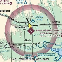
| Sectional chart |
|---|
|
| Airport distance calculator |
|---|
|
|
| Sunrise and sunset |
|---|
|
Times for 15-Apr-2026
| | Local
(UTC-5) | | Zulu
(UTC) |
|---|
| Morning civil twilight | | 06:33 | | 11:33 |
| Sunrise | | 07:01 | | 12:01 |
| Sunset | | 20:14 | | 01:14 |
| Evening civil twilight | | 20:42 | | 01:42 |
|
| Current date and time |
|---|
| Zulu (UTC) | 16-Apr-2026 01:50:10 |
|---|
| Local (UTC-5) | 15-Apr-2026 20:50:10 |
|---|
|
| METAR |
|---|
| KPHG | 160135Z AUTO 23003KT 10SM CLR 20/M04 A2976 RMK AO2
|
|
| NOTAMs |
|---|
NOTAMs are issued by the DoD/FAA and will open in a separate window not controlled by AirNav.
|
|

