FAA INFORMATION EFFECTIVE 17 APRIL 2025
Location
| FAA Identifier: | PYN |
| Lat/Long: | 37-07-34.0950N 090-42-48.7030W
37-07.568250N 090-42.811717W
37.1261375,-90.7135286
(estimated) |
| Elevation: | 466.4 ft. / 142.2 m (surveyed) |
| Variation: | 02E (1985) |
| From city: | 2 miles SW of PIEDMONT, MO |
| Time zone: | UTC -5 (UTC -6 during Standard Time) |
| Zip code: | 63957 |
Airport Operations
| Airport use: | Open to the public |
| Activation date: | 10/1975 |
| Control tower: | no |
| ARTCC: | MEMPHIS CENTER |
| FSS: | SAINT LOUIS FLIGHT SERVICE STATION |
| NOTAMs facility: | STL (NOTAM-D service available) |
| Attendance: | UNATNDD |
| Wind indicator: | lighted |
| Segmented circle: | no |
| Lights: | MIRL RY 03/21 PRESET ON MED INTST & REIL RYS 03 & 21 OPER DUSK-0200; TO INCR INTST MIRL RY 03/21 ACTVT - CTAF. AFT 0200 ACTVT MIRL RY 03/21 & REIL RYS 03 & 21 - CTAF. |
| Beacon: | white-green (lighted land airport)
Operates sunset to sunrise. |
Airport Communications
| CTAF/UNICOM: | 122.8 |
| WX AWOS-3PT: | 118.475 (573-223-2796) |
Airport Services
| Fuel available: | 100LL |
| Parking: | tiedowns |
| Bottled oxygen: | NONE |
| Bulk oxygen: | NONE |
Runway Information
Runway 3/21
| Dimensions: | 3296 x 60 ft. / 1005 x 18 m |
| Surface: | asphalt, in good condition |
| Weight bearing capacity: | |
| Runway edge lights: | medium intensity |
| RUNWAY 3 | | RUNWAY 21 |
| Latitude: | 37-07.338525N | | 37-07.797975N |
| Longitude: | 090-42.992615W | | 090-42.630815W |
| Elevation: | 457.2 ft. | | 466.4 ft. |
| Traffic pattern: | right | | left |
| Runway heading: | 030 magnetic, 032 true | | 210 magnetic, 212 true |
| Markings: | nonprecision, in good condition | | nonprecision, in good condition |
| Runway end identifier lights: | yes | | yes |
| Touchdown point: | yes, no lights | | yes, no lights |
| Obstructions: | 102 ft. trees, 1360 ft. from runway, 250 ft. left and right of centerline, 11:1 slope to clear | | 38 ft. trees, 830 ft. from runway, 12 ft. left of centerline, 16:1 slope to clear |
Airport Ownership and Management from official FAA records
| Ownership: | Publicly-owned |
| Owner: | CITY OF PIEDMONT
115 W. GREEN STREET, P.O. BOX 25
PIEDMONT, MO 63957
Phone 573-223-7660 |
| Manager: | BILL MCMURRY
115 W GREEN ST BOX 25
PIEDMONT, MO 63957
Phone 573-223-4528 |
Additional Remarks
| - | LAST 35 FT OF TURNAROUND AT SE TWY NOT USBL; PILOTS OF LOW WING ACFT USE CARE. |
| - | BIRDS & WILDLIFE ON & INVOF ARPT. |
| - | FOR CD CTC MEMPHIS ARTCC AT 901-368-8453/8449. |
Instrument Procedures
There are no published instrument procedures at KPYN.
Some nearby airports with instrument procedures:
KPOF - Poplar Bluff Regional Business Airport (28 nm SE)
H88 - A Paul Vance Fredericktown Regional Airport (35 nm NE)
KFAM - Farmington Regional Airport (40 nm N)
KDXE - Dexter Municipal Airport (43 nm SE)
4M9 - Corning Municipal Airport (43 nm S)
|
|

Road maps at:
MapQuest
Bing
Google
| Aerial photo |
|---|
WARNING: Photo may not be current or correct

Do you have a better or more recent aerial photo of Piedmont Municipal Airport that you would like to share? If so, please send us your photo.
|
| Sectional chart |
|---|
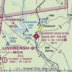
|
| Airport distance calculator |
|---|
|
|
| Sunrise and sunset |
|---|
|
Times for 03-May-2025
| | Local
(UTC-5) | | Zulu
(UTC) |
|---|
| Morning civil twilight | | 05:39 | | 10:39 |
| Sunrise | | 06:07 | | 11:07 |
| Sunset | | 19:52 | | 00:52 |
| Evening civil twilight | | 20:21 | | 01:21 |
|
| Current date and time |
|---|
| Zulu (UTC) | 03-May-2025 18:09:58 |
|---|
| Local (UTC-5) | 03-May-2025 13:09:58 |
|---|
|
| METAR |
|---|
KPOF
29nm SE | 031753Z AUTO 33013G18KT 10SM FEW037 SCT044 BKN075 18/09 A2990 RMK AO2 SLP122 60001 T01830094 10189 20139 58002
|
KFAM
41nm N | 031756Z AUTO 33008G17KT 10SM SCT032 BKN065 OVC085 15/08 A2992 RMK AO2 SLP139 60000 T01500078 10150 20111 58003
|
K4M9
43nm S | 031755Z AUTO 33010KT 300V010 10SM 18/12 A2992 RMK A01
|
KMAW
47nm SE | 031755Z AUTO 32014KT 10SM SCT034 SCT080 19/11 A2991 RMK AO1
|
|
| NOTAMs |
|---|
NOTAMs are issued by the DoD/FAA and will open in a separate window not controlled by AirNav.
|
|


