FAA INFORMATION EFFECTIVE 27 NOVEMBER 2025
Location
| FAA Identifier: | RBW |
| Lat/Long: | 32-55-15.7460N 080-38-26.1230W
32-55.262433N 080-38.435383W
32.9210406,-80.6405897
(estimated) |
| Elevation: | 100.9 ft. / 30.8 m (surveyed) |
| Variation: | 05W (1990) |
| From city: | 2 miles NE of WALTERBORO, SC |
| Time zone: | UTC -5 (UTC -4 during Daylight Saving Time) |
| Zip code: | 29488 |
Airport Operations
| Airport use: | Open to the public |
| Activation date: | 10/1937 |
| Control tower: | no |
| ARTCC: | JACKSONVILLE CENTER |
| FSS: | ANDERSON FLIGHT SERVICE STATION |
| NOTAMs facility: | AND (NOTAM-D service available) |
| Attendance: | 0830-1800 |
| Wind indicator: | lighted, (WIND INDCR) SUPPLRY LGTD WINDCONES RWY 23 AND MIDFIELD. |
| Segmented circle: | no |
| Lights: | ODALS RWY 23; REILS RWY 23; PAPI RWY 05 & 23; MIRLS RWY 05/23 - OPR CONSLY FM DUSK-2200. FM 2200 TO DAWN ACTVT ODALS RWY 23; MIRLS RWY 05/23 - CTAF. |
| Beacon: | white-green (lighted land airport)
Operates sunset to sunrise. |
Airport Communications
| CTAF/UNICOM: | 122.8 |
| WX AWOS-3PT: | 118.725 (843-538-3575) |
| CHARLESTON APPROACH: | 120.7 [OPR 1100-0300Z++ MON-FRI, 1300-2100Z++ SAT-SUN, CLSD FED HOL, AND ACC FAMILY DAYS.] |
| CHARLESTON DEPARTURE: | 120.7 [OPR 1100-0300Z++ MON-FRI, 1300-2100Z++ SAT-SUN, CLSD FED HOL, AND ACC FAMILY DAYS.] |
| WX AWOS-3 at DYB (20 nm NE): | 119.575 (843-821-8403) |
Nearby radio navigation aids
| VOR radial/distance | | VOR name | | Freq | | Var |
|---|
| CHSr278/30.4 | | CHARLESTON VORTAC | | 113.50 | | 05W |
| ALDr100/(33.3) | | ALLENDALE VOR | | 116.70 | | 01W |
Airport Services
| Fuel available: | 100LL JET-A
A:FOR AFT HRS SVC CALL 843-549-2549.
100LL:100LL SELF-SVC FUEL AVBL 24 HRS. |
| Parking: | hangars and tiedowns |
| Airframe service: | MAJOR |
| Powerplant service: | MAJOR |
| Bottled oxygen: | NONE |
| Bulk oxygen: | NONE |
Runway Information
Runway 5/23
| Dimensions: | 6002 x 100 ft. / 1829 x 30 m |
| Surface: | asphalt/concrete, in good condition |
| Weight bearing capacity: | | PCN 26 /F/B/X/T | | Single wheel: | 70.0 | | Double wheel: | 101.0 |
|
| Runway edge lights: | medium intensity |
| RUNWAY 5 | | RUNWAY 23 |
| Latitude: | 32-54.943338N | | 32-55.654585N |
| Longitude: | 080-38.720747W | | 080-37.904650W |
| Elevation: | 89.4 ft. | | 100.9 ft. |
| Traffic pattern: | left | | left |
| Runway heading: | 049 magnetic, 044 true | | 229 magnetic, 224 true |
| Declared distances: | TORA:6002 TODA:6002 ASDA:6002 LDA:6002 | | TORA:6002 TODA:6002 ASDA:5977 LDA:5977 |
| Markings: | nonprecision, in good condition | | precision, in good condition |
| Visual slope indicator: | 2-light PAPI on left (3.50 degrees glide path) | | 2-light PAPI on left (3.00 degrees glide path) |
| Approach lights: | | | ODALS: omnidirectional approach lighting system |
| Runway end identifier lights: | no | | yes |
| Touchdown point: | yes, no lights | | yes, no lights |
| Instrument approach: | | | ILS/DME |
| Obstructions: | 82 ft. trees, 1999 ft. from runway, 265 ft. right of centerline, 21:1 slope to clear | | 83 ft. trees, 2527 ft. from runway, 823 ft. left of centerline, 28:1 slope to clear |
Runway 17/35
| Dimensions: | 5705 x 100 ft. / 1739 x 30 m |
| Surface: | asphalt/concrete, in excellent condition |
| Weight bearing capacity: | | PCN 10 /F/B/X/T | | Single wheel: | 33.5 | | Double wheel: | 50.5 |
|
| RUNWAY 17 | | RUNWAY 35 |
| Latitude: | 32-55.679600N | | 32-54.768353N |
| Longitude: | 080-38.703032W | | 080-38.425835W |
| Elevation: | 82.3 ft. | | 91.6 ft. |
| Traffic pattern: | left | | left |
| Runway heading: | 171 magnetic, 166 true | | 351 magnetic, 346 true |
| Markings: | nonprecision, in good condition | | nonprecision, in good condition |
| Runway end identifier lights: | no | | no |
| Touchdown point: | yes, no lights | | yes, no lights |
| Obstructions: | 17 ft. tree, 233 ft. from runway, 74 ft. left of centerline, 1:1 slope to clear | | 57 ft. tree, 2370 ft. from runway, 43 ft. left of centerline, 38:1 slope to clear |
Airport Ownership and Management from official FAA records
| Ownership: | Publicly-owned |
| Owner: | CITY OF WALTERBORO AND COLLETON CO.
537 AVIATION WAY
WALTERBORO, SC 29488
Phone 843-549-2549 |
| Manager: | BERT DUFFIE
537 AVIATION WAY
WALTERBORO, SC 29488
Phone 843-955-0290 |
Additional Remarks
| - | FOR CD CTC CHARLESTON APCH AT 843 414-2832. |
| - | DEER ON AND INVOF ARPT WITH INCR ACT DRG NGT AND AT DUSK AND DAWN. |
Instrument Procedures
NOTE: All procedures below are presented as PDF files. If you need a reader for these files, you should download the free Adobe Reader.NOT FOR NAVIGATION. Please procure official charts for flight.
FAA instrument procedures published for use from 27 November 2025 at 0901Z to 25 December 2025 at 0900Z.
IAPs - Instrument Approach Procedures |
|---|
| ILS Y OR LOC Y RWY 23 **CHANGED** | |
download (286KB) |
| ILS Z OR LOC Z RWY 23 **CHANGED** | |
download (290KB) |
| RNAV (GPS) RWY 05 **CHANGED** | |
download (255KB) |
| RNAV (GPS) RWY 17 **CHANGED** | |
download (262KB) |
| RNAV (GPS) RWY 23 **CHANGED** | |
download (275KB) |
| RNAV (GPS) RWY 35 **CHANGED** | |
download (265KB) |
| NOTE: Special Alternate Minimums apply | |
download (167KB) |
| NOTE: Special Take-Off Minimums/Departure Procedures apply | |
download (386KB) |
Other nearby airports with instrument procedures:
6J2 - St George Airport (18 nm N)
KDYB - Summerville Airport (20 nm NE)
KNBC - Beaufort Marine Corps Air Station (Merritt Field) Airport (27 nm S)
KCHS - Charleston Air Force Base/International Airport (30 nm E)
KARW - Beaufort Executive Airport (31 nm S)
|
|

Road maps at:
MapQuest
Bing
Google
| Aerial photo |
|---|
WARNING: Photo may not be current or correct
 Photo by Nick Green
Photo taken 16-Jan-2012
looking northeast at 3500
Photo by Nick Green
Photo taken 16-Jan-2012
looking northeast at 3500
Do you have a better or more recent aerial photo of Lowcountry Regional Airport that you would like to share? If so, please send us your photo.
|
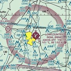
| Sectional chart |
|---|
|
CAUTION: Diagram may not be current

| Airport distance calculator |
|---|
|
|
| Sunrise and sunset |
|---|
|
Times for 01-Dec-2025
| | Local
(UTC-5) | | Zulu
(UTC) |
|---|
| Morning civil twilight | | 06:41 | | 11:41 |
| Sunrise | | 07:08 | | 12:08 |
| Sunset | | 17:15 | | 22:15 |
| Evening civil twilight | | 17:42 | | 22:42 |
|
| Current date and time |
|---|
| Zulu (UTC) | 01-Dec-2025 09:38:54 |
|---|
| Local (UTC-5) | 01-Dec-2025 04:38:54 |
|---|
|
| METAR |
|---|
| KRBW | 010915Z AUTO 35006KT 10SM 11/09 A3024 RMK AO2
|
|
| TAF |
|---|
KCHS
31nm E | 010520Z 0106/0206 01004KT P6SM BKN020 FM010700 02007KT P6SM BKN035 FM012100 06008KT P6SM OVC030 FM020100 05009KT P6SM OVC015
|
KOGB
34nm N | 010530Z 0106/0206 03004KT P6SM VCSH SCT070 BKN100 TEMPO 0106/0108 5SM -RA BR SCT020 BKN035 FM010900 05007KT P6SM OVC040 FM011500 06010KT P6SM BKN040 FM020200 07006KT P6SM VCSH OVC040 TEMPO 0202/0206 4SM -RA BR OVC025
|
|
| NOTAMs |
|---|
NOTAMs are issued by the DoD/FAA and will open in a separate window not controlled by AirNav.
|
|


