FAA INFORMATION EFFECTIVE 09 JULY 2026
Location
| FAA Identifier: | RNP |
| Lat/Long: | 42-59-34.7000N 084-08-18.6000W
42-59.578333N 084-08.310000W
42.9929722,-84.1385000
(estimated) |
| Elevation: | 736.7 ft. / 224.5 m (surveyed) |
| Variation: | 06W (2000) |
| From city: | 2 miles E of OWOSSO, MI |
| Time zone: | UTC -4 (UTC -5 during Standard Time) |
| Zip code: | 48867 |
Airport Operations
| Airport use: | Open to the public |
| Activation date: | 04/1940 |
| Control tower: | no |
| ARTCC: | CLEVELAND CENTER |
| FSS: | LANSING FLIGHT SERVICE STATION |
| NOTAMs facility: | RNP (NOTAM-D service available) |
| Attendance: | MON-FRI 0900-1700, ALL SAT-SUN PRIOR ARNGMT |
| Wind indicator: | lighted |
| Segmented circle: | yes |
| Lights: | ACTVT REIL RWY 11 & 29; PAPI RWY 11 & 29; MIRL RWY 11/29 - CTAF. PAPI RWY 11 & 29 OPR CONSLY SR-SS. |
| Beacon: | white-green (lighted land airport)
Operates sunset to sunrise. |
Airport Communications
| CTAF/UNICOM: | 123.0 |
| WX AWOS-3P: | 118.025 (989-729-2967) |
| GREAT LAKES APPROACH: | 128.55 |
| GREAT LAKES DEPARTURE: | 128.55 |
| WX ASOS at FNT (17 nm E): | PHONE 810-202-2914 |
- APCH/DEP SVC PRVDD BY CLEVELAND ARTCC (ZOB) ON FREQS 126.75/348.75 (FLINT RCAG) WHEN GREAT LAKES APCH CTL CLSD.
Nearby radio navigation aids
| VOR radial/distance | | VOR name | | Freq | | Var |
|---|
| FNTr281/17.3 | | FLINT VORTAC | | 116.90 | | 06W |
| MBSr188/32.4 | | SAGINAW VOR/DME | | 114.35 | | 03W |
Airport Services
| Fuel available: | 100LL |
| Parking: | hangars and tiedowns |
| Airframe service: | MAJOR
FOR SVC CALL 989-413-7824. |
| Powerplant service: | MAJOR |
| Bottled oxygen: | NONE |
| Bulk oxygen: | NONE |
Runway Information
Runway 11/29
| Dimensions: | 4300 x 75 ft. / 1311 x 23 m |
| Surface: | asphalt, in fair condition |
| Weight bearing capacity: | |
| Runway edge lights: | medium intensity |
| RUNWAY 11 | | RUNWAY 29 |
| Latitude: | 42-59.655005N | | 42-59.499763N |
| Longitude: | 084-08.805615W | | 084-07.864893W |
| Elevation: | 733.2 ft. | | 736.6 ft. |
| Traffic pattern: | left | | left |
| Runway heading: | 109 magnetic, 103 true | | 289 magnetic, 283 true |
| Markings: | nonprecision, in good condition | | nonprecision, in good condition |
| Visual slope indicator: | 4-light PAPI on left (3.00 degrees glide path)
PAPI UNUSBL BYD 4 DEGS LEFT OF CNTRLN. | | 4-light PAPI on right (3.00 degrees glide path) |
| Runway end identifier lights: | yes | | yes |
| Touchdown point: | yes, no lights | | yes, no lights |
| Obstructions: | 13 ft. road, 272 ft. from runway, 463 ft. right of centerline, 5:1 slope to clear
CTLG OBSTN EXCEEDS A 45 DEG SLP. | | 4 ft. brush, 200 ft. from runway, 155 ft. left of centerline |
Runway 18/36
| Dimensions: | 2509 x 260 ft. / 765 x 79 m |
| Surface: | turf, in good condition
ROLLING TRRN; OPPOSITE APCH END NOT VSB. |
| Runway edge markings: | RWY & DTHR MKD WITH 3 FT YELLOW CONES. |
| Operational restrictions: | CLSD DEC 1 THRU MAR 31 & WHEN SNOW COVD. |
| RUNWAY 18 | | RUNWAY 36 |
| Latitude: | 42-59.735110N | | 42-59.323403N |
| Longitude: | 084-08.210063W | | 084-08.166720W |
| Elevation: | 735.7 ft. | | 729.8 ft. |
| Traffic pattern: | left | | left |
| Runway heading: | 182 magnetic, 176 true | | 002 magnetic, 356 true |
| Displaced threshold: | 364 ft. | | 1161 ft. |
| Touchdown point: | yes, no lights | | yes, no lights |
| Obstructions: | 34 ft. tree, 154 ft. from runway, 155 ft. right of centerline, 4:1 slope to clear
APCH RATIO 19:1 TO DTHR OVR +37 FT TREE, 724 FT DIST, 20 FT L. | | 51 ft. tree, 17 ft. from runway
CTLG OBSTN EXCEEDS A 45 DEG SLP. APCH RATIO 19:1 TO DTHR OVR +75 FT TREES, 1467 FT DIST, 0 FT B. |
Runway 6/24
| Dimensions: | 2446 x 130 ft. / 746 x 40 m |
| Surface: | turf, in good condition |
| Runway edge markings: | 3 FT YELLOW CONES. |
| Operational restrictions: | CLSD DEC 1 THRU MAR 31 & WHEN SNOW COVD. |
| RUNWAY 6 | | RUNWAY 24 |
| Latitude: | 42-59.522760N | | 42-59.733000N |
| Longitude: | 084-08.621150W | | 084-08.153240W |
| Elevation: | 729.7 ft. | | 735.7 ft. |
| Traffic pattern: | left | | left |
| Runway heading: | 065 magnetic, 059 true | | 245 magnetic, 239 true |
| Displaced threshold: | 1047 ft. | | no |
| Touchdown point: | yes, no lights | | yes, no lights |
| Obstructions: | 35 ft. tree, 125 ft. right of centerline
CTLG OBSTN EXCEEDS A 45 DEG SLP. APCH RATIO 20:1 TO DTHR. | | 11 ft. fence, 154 ft. from runway, 145 ft. right of centerline, 14:1 slope to clear |
Airport Ownership and Management from official FAA records
| Ownership: | Publicly-owned |
| Owner: | SHIAWASSEE AIRPORT BOARD
205 AIRPORT DR
OWOSSO, MI 48867-9153
Phone 989-725-1969 |
| Manager: | GARRY CSAPOS
205 AIRPORT DR
OWOSSO, MI 48867-9153
Phone 989-725-1969 |
Additional Remarks
| - | DEER & LRG BIRDS ON & INVOF ARPT. |
| - | FOR CD CTC GREAT LAKES APCH AT 269-459-3345, WHEN APCH CLSD CTC CLEVELAND ARTCC AT 440-774-0224/0490. |
Instrument Procedures
NOTE: All procedures below are presented as PDF files. If you need a reader for these files, you should download the free Adobe Reader.NOT FOR NAVIGATION. Please procure official charts for flight.
FAA instrument procedures published for use from 09 July 2026 at 0901Z to 06 August 2026 at 0900Z.
IAPs - Instrument Approach Procedures |
|---|
| RNAV (GPS) RWY 11 | |
download (218KB) |
| RNAV (GPS) RWY 29 | |
download (214KB) |
| VOR/DME RWY 29 | |
download (210KB) |
| NOTE: Special Alternate Minimums apply | |
download (65KB) |
| NOTE: Special Take-Off Minimums/Departure Procedures apply | |
download (122KB) |
Other nearby airports with instrument procedures:
KFNT - Bishop International Airport (17 nm E)
9G2 - Price's Airport (20 nm SE)
KOZW - Livingston County/Spencer J Hardy Airport (23 nm S)
KLAN - Capital Region International Airport (24 nm SW)
KTEW - Mason Jewett Field Airport (29 nm SW)
|
|

Road maps at:
MapQuest
Bing
Google
| Aerial photo |
|---|
WARNING: Photo may not be current or correct
 Photo by Rick Anderson of Skypixs Aerial Photography.
Photo taken 20-Jun-2009
Photo by Rick Anderson of Skypixs Aerial Photography.
Photo taken 20-Jun-2009
Do you have a better or more recent aerial photo of Owosso Community Airport that you would like to share? If so, please send us your photo.
|
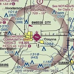
| Sectional chart |
|---|
|
| Airport distance calculator |
|---|
|
|
| Sunrise and sunset |
|---|
|
Times for 18-Jul-2026
| | Local
(UTC-4) | | Zulu
(UTC) |
|---|
| Morning civil twilight | | 05:41 | | 09:41 |
| Sunrise | | 06:15 | | 10:15 |
| Sunset | | 21:11 | | 01:11 |
| Evening civil twilight | | 21:45 | | 01:45 |
|
| Current date and time |
|---|
| Zulu (UTC) | 18-Jul-2026 04:54:59 |
|---|
| Local (UTC-4) | 18-Jul-2026 00:54:59 |
|---|
|
| METAR |
|---|
| KRNP | 180435Z AUTO 24004KT 5SM HZ CLR 23/20 A2989 RMK AO2
|
KFNT
17nm E | 180433Z AUTO 21006KT 3SM FU CLR 23/21 A2990 RMK AO2 T02330206
|
|
| TAF |
|---|
KFNT
17nm E | 172106Z 1721/1818 16005KT 2SM FU SCT026 BKN045 TEMPO 1800/1802 2SM TSRA HZ BKN022 OVC045CB FM180200 23007KT 6SM HZ SCT040 OVC120 FM181400 24014G23KT P6SM SCT030 BKN050 OVC120 PROB30 1815/1818 3SM TSRA OVC030CB
|
|
| NOTAMs |
|---|
NOTAMs are issued by the DoD/FAA and will open in a separate window not controlled by AirNav.
|
|

