FAA INFORMATION EFFECTIVE 11 JUNE 2026
Location
| FAA Identifier: | RNT |
| Lat/Long: | 47-29-35.3000N 122-12-56.7000W
47-29.588333N 122-12.945000W
47.4931389,-122.2157500
(estimated) |
| Elevation: | 32 ft. / 9.8 m (surveyed) |
| Variation: | 17E (2010) |
| Time zone: | UTC -7 (UTC -8 during Standard Time) |
| Zip code: | 98055 |
Airport Operations
| Airport use: | Open to the public |
| Activation date: | 04/1945 |
| Control tower: | yes |
| ARTCC: | SEATTLE CENTER |
| FSS: | SEATTLE FLIGHT SERVICE STATION |
| NOTAMs facility: | RNT (NOTAM-D service available) |
| Attendance: | 0700-DUSK |
| Pattern altitude: | 1250 ft. MSL
TPA WEST OF THE ARPT IS 1218 FT AGL DUE TO TRRN IMTLY WEST OF THE ARPT. |
| Wind indicator: | lighted |
| Segmented circle: | no |
| Lights: | ACTVT REIL RWY 16 & 34; MIRL RWY 16/34 AND TWY LGTS - CTAF. PAPI RWY 16 & 34 ON CONSLY. |
| Beacon: | white-green (lighted land airport)
Operates sunset to sunrise. |
| International operations: | customs landing rights airport |
Airport Communications
| CTAF: | 124.7 |
| UNICOM: | 122.95 |
| ATIS: | 126.95 |
| WX ASOS: | 126.95 (425-255-6080) |
| RENTON GROUND: | 121.6 256.9 [OCT 1-APR 30 0700-2000; MAY 1-SEP 30 0700-2100] |
| RENTON TOWER: | 124.7 256.9 [OCT 1-APR 30 0700-2000; MAY 1-SEP 30 0700-2100] |
| SEATTLE APPROACH: | 119.2 ;017-079 SEA RWY 34 119.2 ;028-160 SEA RWY 16 120.1 ;223-289 SEA, RWY 16 120.1 ;223-301 SEA, RWY 34 120.4 ;301-340 SEA, RWY 34 123.9 ;RWY 16 125.9 ;080-125 SEA, RWY 34 125.9 ;290-315 SEA, RWY 16 125.9 ;RWY 34 126.5 ;126-222 SEA, RWY 34 126.5 ;161-222 SEA, RWY 16 128.5 ;302-016 SEA, RWY 34 128.5 ;316-027 SEA, RWY 16 |
| SEATTLE DEPARTURE: | 119.2 ;028-160 SEA RWY 16 120.1 ;223-289 SEA, RWY 16 120.1 ;223-301 SEA, RWY 34 120.4 ;301-340 SEA, RWY 34 125.9 ;080-125 SEA, RWY 34 125.9 ;290-315 SEA, RWY 16 126.5 ;126-222 SEA, RWY 34 126.5 ;161-222 SEA, RWY 16 128.5 ;302-016 SEA, RWY 34 128.5 ;316-027 SEA, RWY 16 |
| BELLEVUE DP: | 119.2 |
| CLASS B: | 119.2 ;017-079 SEA, RWY 34 119.2 ;028-160 SEA RWY 16 120.1 ;223-289 SEA, RWY 16 120.1 ;223-301 SEA, RWY 34 125.9 ;080-125 SEA, RWY 34 125.9 ;290-315 SEA RWY 16 126.5 ;126-222 SEA, RWY 34 126.5 ;161-222 SEA, RWY 16 128.5 ;302-016 SEA, RWY 34 128.5 ;316-027 SEA RWY 16 |
| DE/P: | 119.2 ;017-079 SEA RWY 34 |
| GLASR STAR: | 123.9 |
| IC: | 123.9 ;RWY 16 125.9 ;RWY 34 |
| OLYMPIA STAR: | 125.6 |
| RENTN DP: | 119.2 |
| WX ASOS at BFI (4 nm NW): | PHONE 206-658-6435 |
| WX ASOS at SEA (5 nm SW): | PHONE 206-214-2592 |
| WX ASOS at TIW (20 nm SW): | PHONE 253-858-6507 |
- ACFT RQRG SVCS CTC 122.85 OR 122.77.
- APCH/DEP SECTORIZATION BASED ON SEATTLE-TACOMA INTL SECTORIZATION.
- FREQ 121.5 NOT AVBL.
Nearby radio navigation aids
| VOR radial/distance | | VOR name | | Freq | | Var |
|---|
| SEAr029/5.1 | | SEATTLE VORTAC | | 116.80 | | 19E |
| PAEr154/25.7 | | PAINE VOR/DME | | 110.60 | | 20E |
Airport Services
| Fuel available: | 100LL JET-A JET-A+ |
| Parking: | tiedowns |
| Airframe service: | MAJOR |
| Powerplant service: | MAJOR |
| Bottled oxygen: | HIGH/LOW |
| Bulk oxygen: | HIGH/LOW |
Runway Information
Runway 16/34
| Dimensions: | 5382 x 200 ft. / 1640 x 61 m |
| Surface: | asphalt/concrete/grooved, in good condition |
| Weight bearing capacity: | | Single wheel: | 100.0 | | Double wheel: | 130.0 | | Double tandem: | 340.0 |
|
| Runway edge lights: | medium intensity |
| RUNWAY 16 | | RUNWAY 34 |
| Latitude: | 47-30.028453N | | 47-29.147715N |
| Longitude: | 122-13.011177W | | 122-12.877877W |
| Elevation: | 24.1 ft. | | 32.0 ft. |
| Traffic pattern: | left | | right |
| Runway heading: | 157 magnetic, 174 true | | 337 magnetic, 354 true |
| Displaced threshold: | 304 ft. | | 340 ft. |
| Declared distances: | TORA:5382 TODA:5382 ASDA:5042 LDA:4742 | | TORA:5382 TODA:5382 ASDA:5082 LDA:4742 |
| Markings: | nonprecision, in good condition | | nonprecision, in good condition |
| Visual slope indicator: | 2-light PAPI on left (3.50 degrees glide path) | | 2-light PAPI on left (3.75 degrees glide path) |
| Runway end identifier lights: | yes | | yes |
| Touchdown point: | yes, no lights | | yes, no lights |
| Obstructions: | 290 ft. trees, 10000 ft. from runway, 33:1 slope to clear
10,000 FT FM RWY THR. | | 15 ft. road, 200 ft. from runway
APCH SLOPE 13:1 TO DTHR DUE TO 1323 FT TREE 442 FT LEFT OF CNTRLN; 17:1 TO DTHR DUE TO 933 FT TREE 180 FT LEFT OF CTRLN; 26:1 DUE TO 20 FT BLAST FENCE 530 FT FM DTHR. |
Airport Ownership and Management from official FAA records
| Ownership: | Publicly-owned |
| Owner: | CITY OF RENTON
1055 SOUTH GRADY WAY
RENTON, WA 98055
Phone 425-430-6400 |
| Manager: | MANNY CRUZ
243 WEST PERIMETER ROAD, UNIT A
RENTON, WA 98057
Phone 425-430-7476
EMAIL - MCRUZ@RENTONWA.GOV |
Additional Remarks
| - | RY 34 12 FT BLAST FENCE 155 FT FM EOR. |
| - | TWY B BTN TWY B3 AND TWY B5 CLSD TO ACFT WITH WING SPAN 50 FT OR OVR. |
| - | EMER FREQ 121.5 NOT MNT AT TWR. |
| - | DURG RNT TWR HRS OF OPS AND VMC WX, RNT TWR HAS CTL OF THE WEST CHANNEL, OVR THE WATER BLO 800 FT AGL. IF OPR IN THE WEST CHANNEL ABV 800 FT AGL OR WHEN RNT ATCT CLSD, CTC BOEING TWR, 118.3, PRIOR TO OPR IN THE WEST CHANNEL. |
| - | FOR CD WHEN ATCT IS CLSD CTC SEATTLE APCH AT 206-214-4722. |
| - | WHEN ATCT CLSD RNAV (GPS) RWY 16 IS PREFERRED IAP. |
| - | NUMEROUS FLOCKS OF BIRDS INVOF ARPT & ALONG LAKE WASHINGTON SHORELINE AT ALL TIMES. |
| - | WEST TWY CLSD TO ACFT WITH WING SPAN 118 FT OR OVR. |
| - | AFIS (ADCUS) AVBL. |
| - | BE ALERT FOR BOEING PRODUCTION ACFT BEING TOWED ACRS THE RY DURG HRS ATCT CLOSED. |
| - | NOISE ABATEMENT PROC IN EFCT: CTC ADMIN 425-430-7471. |
| - | SPB NW CORNER ARPT. |
Instrument Procedures
NOTE: All procedures below are presented as PDF files. If you need a reader for these files, you should download the free Adobe Reader.NOT FOR NAVIGATION. Please procure official charts for flight.
FAA instrument procedures published for use from 11 June 2026 at 0901Z to 09 July 2026 at 0900z.
STARs - Standard Terminal Arrivals |
|---|
| CHINS FIVE **NEW** | |
2 pages:
[1] [2] (344KB) |
| GLASR THREE **NEW** | |
2 pages:
[1] [2] (366KB) |
| OLYMPIA TWO **NEW** | |
2 pages:
[1] [2] (303KB) |
| SKYKO ONE **NEW** | |
download (232KB) |
IAPs - Instrument Approach Procedures |
|---|
| RNAV (GPS) RWY 34 | |
download (266KB) |
| RNAV (GPS) Y RWY 16 | |
download (233KB) |
| RNAV (GPS) Z RWY 16 | |
download (236KB) |
| NOTE: Special Alternate Minimums apply | |
download (211KB) |
Departure Procedures |
|---|
| BELLEVUE FOUR | |
download (145KB) |
| RENTN THREE | |
download (157KB) |
| NOTE: Special Take-Off Minimums/Departure Procedures apply | |
download (455KB) |
Other nearby airports with instrument procedures:
KBFI - Boeing Field/King County International Airport (4 nm NW)
KSEA - Seattle-Tacoma International Airport (5 nm SW)
S50 - Auburn Municipal Airport (10 nm S)
KTIW - Tacoma Narrows Airport (20 nm SW)
KPWT - Bremerton National Airport (22 nm W)
|
|

Road maps at:
MapQuest
Bing
Google
| Aerial photo |
|---|
WARNING: Photo may not be current or correct
 Photo by Trent Thomas
Photo taken 24-Aug-2022
taken facing N/NE at 7,500 MSL
Photo by Trent Thomas
Photo taken 24-Aug-2022
taken facing N/NE at 7,500 MSL
Do you have a better or more recent aerial photo of Renton Municipal Airport that you would like to share? If so, please send us your photo.
|
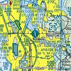
| Sectional chart |
|---|
|
CAUTION: Diagram may not be current
 Download PDF
of official airport diagram from the FAA
| Airport distance calculator |
|---|
|
|
| Sunrise and sunset |
|---|
|
Times for 22-Jun-2026
| | Local
(UTC-7) | | Zulu
(UTC) |
|---|
| Morning civil twilight | | 04:32 | | 11:32 |
| Sunrise | | 05:13 | | 12:13 |
| Sunset | | 21:09 | | 04:09 |
| Evening civil twilight | | 21:49 | | 04:49 |
|
| Current date and time |
|---|
| Zulu (UTC) | 22-Jun-2026 21:39:45 |
|---|
| Local (UTC-7) | 22-Jun-2026 14:39:45 |
|---|
|
| METAR |
|---|
| KRNT | 222053Z 33011KT 10SM CLR 27/12 A3003 RMK AO2 SLP173 T02670117 56009
|
KSEA
5nm SW | 222053Z 36011KT 10SM FEW060 FEW250 27/11 A3005 RMK AO2 SLP180 T02670111 56007
|
KBFI
5nm NW | 222053Z 31009G19KT 10SM CLR 25/10 A3003 RMK AO2 SLP170 T02500100 56008
|
|
| TAF |
|---|
KSEA
5nm SW | 221724Z 2218/2324 34008KT P6SM SKC FM222200 34010G18KT P6SM SKC FM230500 02008KT P6SM FEW250 FM231200 02005KT P6SM FEW250 FM231800 34008KT P6SM SCT250
|
KBFI
5nm NW | 221920Z 2219/2318 32010G18KT P6SM SKC FM230300 34004KT P6SM FEW250 FM230700 VRB03KT P6SM FEW250
|
|
| NOTAMs |
|---|
NOTAMs are issued by the DoD/FAA and will open in a separate window not controlled by AirNav.
|
|


