FAA INFORMATION EFFECTIVE 07 AUGUST 2025
Location
| FAA Identifier: | RPB |
| Lat/Long: | 39-49-03.9350N 097-39-34.5110W
39-49.065583N 097-39.575183W
39.8177597,-97.6595864
(estimated) |
| Elevation: | 1538 ft. / 468.8 m (surveyed) |
| Variation: | 07E (1985) |
| From city: | 1 mile W of BELLEVILLE, KS |
| Time zone: | UTC -5 (UTC -6 during Standard Time) |
| Zip code: | 66935 |
Airport Operations
| Airport use: | Open to the public |
| Activation date: | 05/1945 |
| Control tower: | no |
| ARTCC: | MINNEAPOLIS CENTER |
| FSS: | WICHITA FLIGHT SERVICE STATION |
| NOTAMs facility: | ICT (NOTAM-D service available) |
| Attendance: | UNATNDD |
| Wind indicator: | lighted |
| Segmented circle: | yes
SEGMENTED CIRCLE WITH WIND "T" |
| Lights: | ACTVT PAPI RWY 18 & 36; MIRL 18/36 - CTAF |
| Beacon: | white-green (lighted land airport)
Operates sunset to sunrise. |
Airport Communications
| CTAF/UNICOM: | 122.8 |
| WX ASOS at CNK (16 nm S): | 123.825 (785-262-9693) |
- APCH/DEP SVC PRVDD BY MINNEAPOLIS ARTCC (ZMP) ON FREQ 126.4/317.7 (MARYSVILLE RCAG).
Nearby radio navigation aids
| NDB name | | Hdg/Dist | | Freq | | Var | | ID |
|---|
| FAIRBURY | | 221/31.3 | | 293 | | 06E | | FBY | ..-. -... -.-- |
Airport Services
| Fuel available: | 100LL
100LL:TRANSPORTATION (AVBL 24 HRS) CTC POLICE DISPATCHER ON 785-527-5657. FUEL BY CREDIT CARD. |
| Parking: | hangars and tiedowns |
| Bottled oxygen: | NONE |
| Bulk oxygen: | NONE |
Runway Information
Runway 18/36
| Dimensions: | 3500 x 60 ft. / 1067 x 18 m |
| Surface: | asphalt, in good condition |
| Weight bearing capacity: | | Single wheel: | 12.5 | | Double wheel: | 18.0 |
|
| Runway edge lights: | medium intensity |
| RUNWAY 18 | | RUNWAY 36 |
| Latitude: | 39-49.391167N | | 39-48.815000N |
| Longitude: | 097-39.609667W | | 097-39.629333W |
| Elevation: | 1524.0 ft. | | 1538.0 ft. |
| Traffic pattern: | left | | left |
| Runway heading: | 175 magnetic, 182 true | | 355 magnetic, 002 true |
| Markings: | nonprecision, in good condition | | nonprecision, in good condition |
| Visual slope indicator: | 2-light PAPI on left (3.00 degrees glide path) | | 2-light PAPI on left (3.00 degrees glide path) |
| Touchdown point: | yes, no lights | | yes, no lights |
| Obstructions: | 23 ft. rr, 665 ft. from runway, 20:1 slope to clear | | 7 ft. road, 536 ft. from runway, 20:1 slope to clear |
Runway 14/32
| Dimensions: | 1415 x 100 ft. / 431 x 30 m |
| Surface: | turf, in good condition
RY 14/32 SLIGHTY ROUGH IN SPOTS. |
| Runway edge markings: | APCH DELINEATED BY ORANGE PAINTED MARKERS. |
| RUNWAY 14 | | RUNWAY 32 |
| Latitude: | 39-49.063680N | | 39-48.883683N |
| Longitude: | 097-39.561158W | | 097-39.369167W |
| Elevation: | 1520.0 ft. | | 1523.0 ft. |
| Traffic pattern: | left | | left |
| Runway heading: | 134 magnetic, 141 true | | 314 magnetic, 321 true |
| Markings: | NSTD | | NSTD |
| Obstructions: | none | | 22 ft. bldg, 207 ft. from runway, 127 ft. right of centerline, 9:1 slope to clear
A SMALL SERVICE ROAD RUNS DIAGONALLY ACROSS THE APCH TO RWY 32 APPROXIMATELY 150 T0 200 FT. |
Airport Ownership and Management from official FAA records
| Ownership: | Publicly-owned |
| Owner: | CITY OF BELLEVILLE
1819 L ST
BELLEVILLE, KS 66935
Phone 785-527-2288 |
| Manager: | BRIAN PHILLIPS
1819 L ST
BELLEVILLE, KS 66935
Phone 785-527-3134 |
Additional Remarks
| - | PUBLIC TELEPHONE AVAILABLE IN PILOT'S LOUNGE. |
| - | OCNL ULTRALIGHT ACTVTY ON & INVOF ARPT. |
| - | FOR CD CTC MINNEAPOLIS ARTCC AT 651-463-5588. |
Instrument Procedures
NOTE: All procedures below are presented as PDF files. If you need a reader for these files, you should download the free Adobe Reader.NOT FOR NAVIGATION. Please procure official charts for flight.
FAA instrument procedures published for use from 07 August 2025 at 0901Z to 04 September 2025 at 0900z.
IAPs - Instrument Approach Procedures |
|---|
| RNAV (GPS) RWY 18 | |
download (203KB) |
| RNAV (GPS) RWY 36 | |
download (187KB) |
| NOTE: Special Take-Off Minimums/Departure Procedures apply | |
download (147KB) |
Other nearby airports with instrument procedures:
KCNK - Blosser Municipal Airport (16 nm S)
KHJH - Hebron Municipal Airport (20 nm N)
12K - Superior Municipal Airport (23 nm NW)
K38 - Washington County Veteran's Memorial Airport (29 nm E)
K61 - Moritz Memorial Airport (30 nm SW)
|
|

Road maps at:
MapQuest
Bing
Google
| Aerial photo |
|---|
WARNING: Photo may not be current or correct

Do you have a better or more recent aerial photo of Belleville Municipal Airport that you would like to share? If so, please send us your photo.
|
| Sectional chart |
|---|
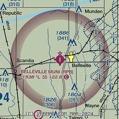
|
| Airport distance calculator |
|---|
|
|
| Sunrise and sunset |
|---|
|
Times for 11-Aug-2025
| | Local
(UTC-5) | | Zulu
(UTC) |
|---|
| Morning civil twilight | | 06:10 | | 11:10 |
| Sunrise | | 06:40 | | 11:40 |
| Sunset | | 20:32 | | 01:32 |
| Evening civil twilight | | 21:01 | | 02:01 |
|
| Current date and time |
|---|
| Zulu (UTC) | 11-Aug-2025 21:17:55 |
|---|
| Local (UTC-5) | 11-Aug-2025 16:17:55 |
|---|
|
| METAR |
|---|
KCNK
16nm S | 112055Z AUTO 04006KT 10SM FEW031 26/18 A3001 RMK AO2 SLP147 T02560183 58005
|
KHJH
20nm N | 112055Z AUTO 00000KT 10SM BKN090 OVC110 23/19 A3002 RMK AO2 T02270194
|
|
| NOTAMs |
|---|
NOTAMs are issued by the DoD/FAA and will open in a separate window not controlled by AirNav.
|
|

