FAA INFORMATION EFFECTIVE 11 JUNE 2026
Location
| FAA Identifier: | SKI |
| Lat/Long: | 42-22-44.6000N 094-58-46.6000W
42-22.743333N 094-58.776667W
42.3790556,-94.9796111
(estimated) |
| Elevation: | 1249.5 ft. / 380.8 m (surveyed) |
| Variation: | 04E (1995) |
| From city: | 3 miles S of SAC CITY, IA |
| Time zone: | UTC -5 (UTC -6 during Standard Time) |
| Zip code: | 50583 |
Airport Operations
| Airport use: | Open to the public |
| Activation date: | 12/1944 |
| Control tower: | no |
| ARTCC: | MINNEAPOLIS CENTER |
| FSS: | FORT DODGE FLIGHT SERVICE STATION |
| NOTAMs facility: | FOD (NOTAM-D service available) |
| Attendance: | MON-FRI 0800-1600 |
| Wind indicator: | lighted |
| Segmented circle: | no |
| Lights: | ACTVT MIRL RWYS 14/32 & 18/36; PAPI RWYS 14, 18, 32 & 36; REIL RWY 36 - CTAF. |
| Beacon: | white-green (lighted land airport)
Operates sunset to sunrise. |
Airport Communications
| CTAF/UNICOM: | 122.8 |
| WX AWOS-3 at SLB (17 nm NW): | 118.525 (712-732-2301) |
- APCH/DEP SVC PRVDD BY MINNEAPOLIS ARTCC ON FREQS 134.0/288.3 (FORT DODGE RCAG).
Airport Services
| Fuel available: | 100LL |
| Parking: | hangars and tiedowns |
| Airframe service: | MINOR |
| Powerplant service: | MINOR |
| Bottled oxygen: | NONE |
| Bulk oxygen: | NONE |
Runway Information
Runway 18/36
| Dimensions: | 4100 x 75 ft. / 1250 x 23 m |
| Surface: | concrete, in fair condition |
| Weight bearing capacity: | |
| Runway edge lights: | medium intensity |
| RUNWAY 18 | | RUNWAY 36 |
| Latitude: | 42-23.020137N | | 42-22.345240N |
| Longitude: | 094-58.762863W | | 094-58.772375W |
| Elevation: | 1245.5 ft. | | 1235.2 ft. |
| Traffic pattern: | left | | left |
| Runway heading: | 177 magnetic, 181 true | | 357 magnetic, 001 true |
| Markings: | nonprecision, in fair condition | | nonprecision, in fair condition |
| Visual slope indicator: | 2-light PAPI on left (3.00 degrees glide path) | | 2-light PAPI on left (3.00 degrees glide path) |
| Runway end identifier lights: | | | yes |
| Touchdown point: | yes, no lights | | yes, no lights |
| Obstructions: | 15 ft. road, 560 ft. from runway, 24:1 slope to clear | | 91 ft. pline, marked, 3760 ft. from runway, 39:1 slope to clear |
Runway 14/32
| Dimensions: | 2350 x 60 ft. / 716 x 18 m |
| Surface: | concrete, in good condition |
| Weight bearing capacity: | | PCN 4 /R/C/W/U | | Single wheel: | 12.5 |
|
| Runway edge lights: | medium intensity |
| RUNWAY 14 | | RUNWAY 32 |
| Latitude: | 42-23.012873N | | 42-22.686995N |
| Longitude: | 094-58.932515W | | 094-58.651243W |
| Elevation: | 1249.5 ft. | | 1236.7 ft. |
| Traffic pattern: | left | | left |
| Runway heading: | 143 magnetic, 147 true | | 323 magnetic, 327 true |
| Markings: | basic, in good condition | | basic, in good condition |
| Visual slope indicator: | 2-light PAPI on left (3.50 degrees glide path) | | 2-light PAPI on left (3.50 degrees glide path) |
| Touchdown point: | yes, no lights | | yes, no lights |
Airport Ownership and Management from official FAA records
| Ownership: | Publicly-owned |
| Owner: | CITY OF SAC CITY
P.O. BOX 37 HWY 20 EAST
SAC CITY, IA 50583
Phone 712-662-7593 |
| Manager: | KEN MYERS
3062 280 TH ST
SAC CITY, IA 50583
Phone 712-662-7801
AFTER HOURS: 712-830-9562 |
Additional Remarks
| - | LINE OF SIGHT PROBLEMS EXIST BTN RYS 36 & 14/32. |
| - | MATT WALLACE - CHAIRMAN ARPT CMSN (712) 662-4806. |
| - | RY 36 IS CALM WIND RY. |
| - | FOR CD CTC MINNEAPOLIS ARTCC AT 651-463-5588. |
Instrument Procedures
NOTE: All procedures below are presented as PDF files. If you need a reader for these files, you should download the free Adobe Reader.NOT FOR NAVIGATION. Please procure official charts for flight.
FAA instrument procedures published for use from 11 June 2026 at 0901Z to 09 July 2026 at 0900z.
IAPs - Instrument Approach Procedures |
|---|
| RNAV (GPS) RWY 18 | |
download (209KB) |
| RNAV (GPS) RWY 36 | |
download (227KB) |
| NOTE: Special Take-Off Minimums/Departure Procedures apply | |
download (422KB) |
Other nearby airports with instrument procedures:
KSLB - Storm Lake Municipal Airport (17 nm NW)
KCIN - Arthur N Neu Airport (22 nm SE)
KPOH - Pocahontas Municipal Airport (26 nm NE)
KDNS - Denison Municipal Airport (30 nm SW)
KCKP - Cherokee County Regional Airport (33 nm NW)
|
|

Road maps at:
MapQuest
Bing
Google
| Aerial photo |
|---|
WARNING: Photo may not be current or correct
 Photo taken 12-Oct-2007
from 8000 feet
Photo taken 12-Oct-2007
from 8000 feet
Do you have a better or more recent aerial photo of Sac City Municipal Airport that you would like to share? If so, please send us your photo.
|
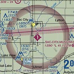
| Sectional chart |
|---|
|
| Airport distance calculator |
|---|
|
|
| Sunrise and sunset |
|---|
|
Times for 04-Jul-2026
| | Local
(UTC-5) | | Zulu
(UTC) |
|---|
| Morning civil twilight | | 05:15 | | 10:15 |
| Sunrise | | 05:49 | | 10:49 |
| Sunset | | 20:59 | | 01:59 |
| Evening civil twilight | | 21:34 | | 02:34 |
|
| Current date and time |
|---|
| Zulu (UTC) | 04-Jul-2026 09:13:39 |
|---|
| Local (UTC-5) | 04-Jul-2026 04:13:39 |
|---|
|
| METAR |
|---|
KSLB
17nm NW | 040855Z AUTO 03006KT 4SM BR BKN005 BKN011 OVC024 22/22 A2999 RMK AO2
|
KCIN
23nm SE | 040855Z AUTO 08011KT 10SM SCT023 BKN041 OVC065 19/19 A3000 RMK AO2 P0001
|
KDNS
30nm SW | 040855Z AUTO 00000KT OVC100 23/23 A2998 RMK AO2
|
KCKP
33nm NW | 040855Z AUTO 03006KT 10SM OVC026 22/22 A2998 RMK AO2
|
|
| TAF |
|---|
KFOD
37nm E | 040520Z 0406/0506 13005KT P6SM OVC040 PROB30 0406/0408 -TSRA SCT040CB FM040800 VRB15G20KT 4SM -TSRA BR BKN040CB FM041000 26006KT P6SM SCT100 FM042000 VRB03KT P6SM SCT100
|
|
| NOTAMs |
|---|
NOTAMs are issued by the DoD/FAA and will open in a separate window not controlled by AirNav.
|
|

