FAA INFORMATION EFFECTIVE 14 MAY 2026
Location
| FAA Identifier: | SRR |
| Lat/Long: | 33-27-39.4000N 105-31-48.5000W
33-27.656667N 105-31.808333W
33.4609444,-105.5301389
(estimated) |
| Elevation: | 6813.8 ft. / 2076.8 m (surveyed) |
| Variation: | 10E (1990) |
| From city: | 15 miles NE of RUIDOSO, NM |
| Time zone: | UTC -6 (UTC -7 during Standard Time) |
| Zip code: | 88324 |
Airport Operations
| Airport use: | Open to the public |
| Activation date: | 12/1987 |
| Control tower: | no |
| ARTCC: | ALBUQUERQUE CENTER |
| FSS: | ALBUQUERQUE FLIGHT SERVICE STATION |
| NOTAMs facility: | SRR (NOTAM-D service available) |
| Attendance: | MAY - OCT 0700-1900, NOV - APR 0700-1800 |
| Wind indicator: | lighted |
| Segmented circle: | yes |
| Lights: | ACTVT REIL RWY 12 & 30; VASI RWY 06; PAPI RWY 12 & 30; MIRL RWY 06/24 & 12/30 - CTAF. |
| Beacon: | white-green (lighted land airport)
Operates sunset to sunrise. |
| Fire and rescue: | ARFF index A |
| Airline operations: | ACR OPS MORE THAN 30 PAX SEATS 24 HR PPR - AMGR. |
Airport Communications
| CTAF/UNICOM: | 122.8 |
| WX AWOS-3: | 126.475 (575-336-8455) |
- APCH/DEP SVC PRVDD BY ALBUQUERQUE ARTCC (ZAB) ON FREQS 132.65/257.6 (ROSWELL RCAG).
Nearby radio navigation aids
| NDB name | | Hdg/Dist | | Freq | | Var | | ID |
|---|
| CAPITAN | | 245/6.5 | | 278 | | 10E | | CEP | -.-. . .--. |
Airport Services
| Fuel available: | 100LL JET-A1+
100LL:AFT HR - 575-973-0074. |
| Parking: | hangars and tiedowns |
Runway Information
Runway 6/24
| Dimensions: | 8120 x 100 ft. / 2475 x 30 m |
| Surface: | asphalt/porous friction courses, in fair condition |
| Weight bearing capacity: | | Single wheel: | 85.0 | | Double wheel: | 125.0 |
|
| Runway edge lights: | medium intensity |
| RUNWAY 6 | | RUNWAY 24 |
| Latitude: | 33-27.557432N | | 33-27.984518N |
| Longitude: | 105-32.841767W | | 105-31.328378W |
| Elevation: | 6813.5 ft. | | 6751.0 ft. |
| Traffic pattern: | left | | left |
| Runway heading: | 061 magnetic, 071 true | | 241 magnetic, 251 true |
| Declared distances: | TORA:8120 TODA:8120 ASDA:8120 LDA:8120 | | TORA:8120 TODA:8120 ASDA:8120 LDA:8120 |
| Markings: | nonprecision, in good condition | | precision, in good condition |
| Visual slope indicator: | 2-box VASI on left (3.00 degrees glide path) | | |
| Touchdown point: | yes, no lights | | yes, no lights |
| Instrument approach: | | | ILS/DME |
Runway 12/30
| Dimensions: | 6309 x 75 ft. / 1923 x 23 m |
| Surface: | asphalt, in good condition |
| Weight bearing capacity: | |
| Runway edge lights: | medium intensity |
| Operational restrictions: | RWY 12/30 NOT AVBL FOR PART 121/PART 380 OPS WITH SKED PAX CARRYING OPS MORE THAN 9 PAX SEATS AND NON-SKED PAX CARRYING OPS MORE THAN 30 PAX SEATS. |
| RUNWAY 12 | | RUNWAY 30 |
| Latitude: | 33-27.860403N | | 33-27.159125N |
| Longitude: | 105-31.912127W | | 105-30.995945W |
| Elevation: | 6772.7 ft. | | 6721.4 ft. |
| Traffic pattern: | left | | left |
| Runway heading: | 122 magnetic, 132 true | | 302 magnetic, 312 true |
| Declared distances: | TORA:6309 TODA:6309 ASDA:6309 LDA:6309 | | TORA:6309 TODA:6309 ASDA:6309 LDA:6309 |
| Markings: | nonprecision, in good condition | | nonprecision, in good condition |
| Visual slope indicator: | 2-light PAPI on left (3.00 degrees glide path) | | 2-light PAPI on left (3.00 degrees glide path) |
| Runway end identifier lights: | yes | | yes |
| Touchdown point: | yes, no lights | | yes, no lights |
Airport Ownership and Management from official FAA records
| Ownership: | Publicly-owned |
| Owner: | VILLAGE OF RUIDOSO
313 CREE MEADOWS DR
RUIDOSO, NM 88345
Phone (575) 336-8111 |
| Manager: | LEE BAKER
313 CREE MEADOWS DR
RUIDOSO, NM 88345
Phone 575-336-8111 |
Additional Remarks
| A39-12/30 | PCR VALUE: 240/F/C/X/T |
| A39-06/24 | PCR VALUE: 690/F/B/X/T |
| - | SFC COND UNMNT WHEN UNATNDD. |
| - | FOR CD IF UNA TO CTC ON FSS FREQ, CTC ALBUQUERQUE ARTCC AT 505-856-4561. |
Instrument Procedures
NOTE: All procedures below are presented as PDF files. If you need a reader for these files, you should download the free Adobe Reader.NOT FOR NAVIGATION. Please procure official charts for flight.
FAA instrument procedures published for use from 14 May 2026 at 0901Z to 11 June 2026 at 0900Z.
IAPs - Instrument Approach Procedures |
|---|
| ILS OR LOC RWY 24 | |
download (284KB) |
| RNAV (GPS) RWY 24 | |
download (229KB) |
| NOTE: Special Alternate Minimums apply | |
download (146KB) |
|
|---|
| CAPITAN TWO (OBSTACLE) | |
download (332KB) |
| NOTE: Special Take-Off Minimums/Departure Procedures apply | |
download (299KB) |
Other nearby airports with instrument procedures:
KALM - Alamogordo-White Sands Regional Airport (44 nm SW)
KHMN - Holloman Air Force Base (47 nm SW)
KROW - Roswell Air Center Airport (51 nm E)
KATS - Artesia Municipal Airport (65 nm SE)
KONM - Socorro Municipal Airport (76 nm NW)
|
|

Road maps at:
MapQuest
Bing
Google
| Aerial photo |
|---|
WARNING: Photo may not be current or correct
 Photo by Patricia Darby
Taken in September 2018
looking WSW.
Photo by Patricia Darby
Taken in September 2018
looking WSW.
Do you have a better or more recent aerial photo of Sierra Blanca Regional Airport that you would like to share? If so, please send us your photo.
|
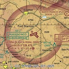
| Sectional chart |
|---|
|
| Airport distance calculator |
|---|
|
|
| Sunrise and sunset |
|---|
|
Times for 15-May-2026
| | Local
(UTC-6) | | Zulu
(UTC) |
|---|
| Morning civil twilight | | 05:35 | | 11:35 |
| Sunrise | | 06:03 | | 12:03 |
| Sunset | | 19:54 | | 01:54 |
| Evening civil twilight | | 20:22 | | 02:22 |
|
| Current date and time |
|---|
| Zulu (UTC) | 16-May-2026 02:34:11 |
|---|
| Local (UTC-6) | 15-May-2026 20:34:11 |
|---|
|
| TAF |
|---|
KHMN
46nm SW | 160040Z 1600/1623 24015G25KT 9999 FEW150 FEW200 QNH2994INS BECMG 1602/1603 20009KT 9999 FEW150 QNH2989INS BECMG 1620/1621 20012G18KT 9999 SKC QNH2976INS TX32/1522Z TN13/1612Z LAST NO AMDS AFT 1640 NEXT 1809
|
|
| NOTAMs |
|---|
NOTAMs are issued by the DoD/FAA and will open in a separate window not controlled by AirNav.
|
|


