FAA INFORMATION EFFECTIVE 19 FEBRUARY 2026
Location
| FAA Identifier: | TKC |
| Lat/Long: | 44-14-57.2620N 095-36-26.0250W
44-14.954367N 095-36.433750W
44.2492394,-95.6072292
(estimated) |
| Elevation: | 1335.7 ft. / 407.1 m (surveyed) |
| Variation: | 05E (1985) |
| From city: | 1 mile NE of TRACY, MN |
| Time zone: | UTC -6 (UTC -5 during Daylight Saving Time) |
| Zip code: | 56175 |
Airport Operations
| Airport use: | Open to the public |
| Activation date: | 03/1947 |
| Control tower: | no |
| ARTCC: | MINNEAPOLIS CENTER |
| FSS: | PRINCETON FLIGHT SERVICE STATION |
| NOTAMs facility: | TKC (NOTAM-D service available) |
| Attendance: | UNATNDD |
| Wind indicator: | lighted |
| Segmented circle: | no |
| Lights: | INCR INTST MIRL RWY 11/29 - CTAF. MIRL RWY 11/29 PRESET LOW INTST. |
| Beacon: | white-green (lighted land airport)
Operates sunset to sunrise. |
Airport Communications
| CTAF: | 122.9 |
| WX AWOS-3PT: | 120.0 (507-629-9006) |
| WX AWOS-3PT at MML (15 nm NW): | 120.150 (507-532-5269) |
| WX AWOS-3 at DVP (17 nm SW): | 118.55 (507-836-6128) |
- APCH/DEP SVC PRVDD BY MINNEAPOLIS ARTCC ON FREQS 127.1/290.2 9 (REDWOOD FALLS RCAG).
Nearby radio navigation aids
| VOR radial/distance | | VOR name | | Freq | | Var |
|---|
| MMLr137/15.2 | | MARSHALL VOR/DME | | 111.00 | | 05E |
| RWFr231/24.4 | | REDWOOD FALLS VOR/DME | | 113.30 | | 07E |
Airport Services
| Fuel available: | 100LL
100LL:100LL AVBL H24 VIA CREDIT CARD. |
| Parking: | tiedowns |
| Airframe service: | NONE |
| Powerplant service: | NONE |
| Bottled oxygen: | NONE |
| Bulk oxygen: | NONE |
Runway Information
Runway 11/29
| Dimensions: | 3098 x 75 ft. / 944 x 23 m |
| Surface: | asphalt, in good condition |
| Runway edge lights: | medium intensity |
| RUNWAY 11 | | RUNWAY 29 |
| Latitude: | 44-15.048163N | | 44-14.805705N |
| Longitude: | 095-36.680813W | | 095-36.056983W |
| Elevation: | 1335.7 ft. | | 1331.2 ft. |
| Traffic pattern: | left | | left |
| Runway heading: | 113 magnetic, 118 true | | 293 magnetic, 298 true |
| Markings: | nonprecision, in good condition | | nonprecision, in good condition |
| Touchdown point: | yes, no lights | | yes, no lights |
| Obstructions: | 26 ft. road, 483 ft. from runway, 286 ft. both sides of centerline, 10:1 slope to clear | | none
LN OF 7 FT BRUSH, 107 FT FM RWY END, LEFT SIDE OF CNTRLN. |
Runway 17/35
| Dimensions: | 1778 x 200 ft. / 542 x 61 m |
| Surface: | turf, in good condition |
| Runway edge markings: | YELLOW CONES. |
| Operational restrictions: | NOT PLOWED WINTER MONTHS. |
| RUNWAY 17 | | RUNWAY 35 |
| Latitude: | 44-15.147718N | | 44-14.856568N |
| Longitude: | 095-36.566800W | | 095-36.526685W |
| Elevation: | 1326.6 ft. | | 1334.8 ft. |
| Traffic pattern: | left | | left |
| Runway heading: | 169 magnetic, 174 true | | 349 magnetic, 354 true |
| Touchdown point: | yes, no lights | | yes, no lights |
Airport Ownership and Management from official FAA records
| Ownership: | Publicly-owned |
| Owner: | CITY OF TRACY
336 MORGAN ST
TRACY, MN 56175-1230
Phone 507-629-5528 |
| Manager: | SHANE DANIELS
336 MORGAN ST, PO BOX 1218
TRACY, MN 56175-0218
Phone 507-629-5545
SDANIELS@TRACYMN.ORG. |
Additional Remarks
| - | FOR CD CTC MINNEAPOLIS ARTCC AT 651-463-5588. |
Instrument Procedures
NOTE: All procedures below are presented as PDF files. If you need a reader for these files, you should download the free Adobe Reader.NOT FOR NAVIGATION. Please procure official charts for flight.
FAA instrument procedures published for use from 19 February 2026 at 0901Z to 19 March 2026 at 0900Z.
IAPs - Instrument Approach Procedures |
|---|
| RNAV (GPS) RWY 11 | |
download (192KB) |
| RNAV (GPS) RWY 29 | |
download (189KB) |
| NOTE: Special Alternate Minimums apply | |
download (153KB) |
| NOTE: Special Take-Off Minimums/Departure Procedures apply | |
download (393KB) |
Other nearby airports with instrument procedures:
KMML - Southwest Minnesota Regional Airport - Marshall/Ryan Field (15 nm NW)
KDVP - Slayton Municipal Airport (17 nm SW)
D42 - Springfield Municipal Airport (26 nm E)
KRWF - Redwood Falls Municipal Airport (29 nm NE)
KMWM - Windom Municipal Airport (29 nm SE)
|
|

Road maps at:
MapQuest
Bing
Google
| Aerial photo |
|---|
WARNING: Photo may not be current or correct
 Photo courtesy of Raptor Aviation, LLC
Do you have a better or more recent aerial photo of Tracy Municipal Airport that you would like to share? If so, please send us your photo.
|
| Sectional chart |
|---|
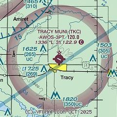
|
| Airport distance calculator |
|---|
|
|
| Sunrise and sunset |
|---|
|
Times for 10-Mar-2026
| | Local
(UTC-5) | | Zulu
(UTC) |
|---|
| Morning civil twilight | | 07:16 | | 12:16 |
| Sunrise | | 07:45 | | 12:45 |
| Sunset | | 19:21 | | 00:21 |
| Evening civil twilight | | 19:50 | | 00:50 |
|
| Current date and time |
|---|
| Zulu (UTC) | 11-Mar-2026 04:49:59 |
|---|
| Local (UTC-5) | 10-Mar-2026 23:49:59 |
|---|
|
| METAR |
|---|
| KTKC | 110435Z AUTO 33014G21KT 2SM -SN BR OVC004 M02/M02 A2996 RMK AO2
|
KMML
15nm NW | 110413Z AUTO 34014KT 2SM -SN BR OVC005 M02/M03 A2999 RMK AO2 CIG 004V008 P0000 FZRANO
|
KDVP
17nm SW | 110433Z AUTO 34017G22KT 4SM -SN M02/M02 A2994 RMK AO2 LTG DSNT S T10171017
|
|
| TAF |
|---|
KRWF
29nm NE | 110129Z 1101/1124 35012KT P6SM BKN012 TEMPO 1101/1103 4SM -RASN BR OVC009 FM110300 36011KT 2SM -SN BR OVC007 TEMPO 1105/1108 1SM -SN BR FM111300 32012G18KT P6SM BKN015 FM111700 31012G18KT P6SM SCT150
|
|
| NOTAMs |
|---|
NOTAMs are issued by the DoD/FAA and will open in a separate window not controlled by AirNav.
|
|

