FAA INFORMATION EFFECTIVE 14 MAY 2026
Location
| FAA Identifier: | TTS |
| Lat/Long: | 28-36-53.6030N 080-41-39.7280W
28-36.893383N 080-41.662133W
28.6148897,-80.6943689
(estimated) |
| Elevation: | 8.5 ft. / 2.6 m (surveyed) |
| Variation: | 05W (1995) |
| From city: | 6 miles E of TITUSVILLE, FL |
| Time zone: | UTC -4 (UTC -5 during Standard Time) |
| Zip code: | 32780 |
Airport Operations
| Airport use: | Private use. Permission required prior to landing |
| Activation date: | 07/1976 |
| Control tower: | yes |
| ARTCC: | JACKSONVILLE CENTER |
| FSS: | SAINT PETERSBURG FLIGHT SERVICE STATION
FSS-ST. PETERSBURG PIE-NOTAM PIE |
| NOTAMs facility: | PIE (NOTAM-D service available) |
| Attendance: | 1300-2200Z++
FOR PPR CALL ARPT MGR. ARPT UNATNDD HOLS. |
| Wind indicator: | lighted |
| Segmented circle: | yes |
| Lights: | ATC CTL. FOR HIRL RY 15/33 CTC TWR - CTAF. |
| Beacon: | white-green (lighted land airport)
Operates sunset to sunrise. |
Airport Communications
| CTAF: | 128.55 |
| NASA GROUND: | 121.75 [0800-1700 MON-FRI, EXC HOL.] |
| NASA TOWER: | 128.55 284.0 [0800-1700 MON-FRI, EXC HOL.] |
| ORLANDO APPROACH: | 134.95 281.425 |
| ORLANDO DEPARTURE: | 134.95 281.425 |
| BITHO STAR: | 128.375 |
| PMSV METRO: | 222.05 |
| WX AWOS-3PT at X21 (7 nm W): | 119.725 (321-385-0383) |
| WX AWOS-3PT at TIX (8 nm SW): | 120.625 (321-567-6090) |
| WX ASOS at XMR (11 nm SE): | 119.325 |
| WX AWOS-3PT at COI (16 nm S): | 119.025 (321-986-8864) |
Nearby radio navigation aids
| VOR radial/distance | | VOR name | | Freq | | Var |
|---|
| MLBr001/30.7 | | MELBOURNE VOR/DME | | 115.85 | | 07W |
| ORLr083/34.0 | | ORLANDO VORTAC | | 112.20 | | 00E |
Airport Services
Runway Information
Runway 15/33
| Dimensions: | 15001 x 300 ft. / 4572 x 91 m |
| Surface: | concrete/grooved, in good condition |
| Weight bearing capacity: | | Single wheel: | 120.0 | | Double wheel: | 220.0 | | Double tandem: | 500.0 | | Dual double tandem: | 800.0 |
|
| Runway edge lights: | high intensity
RY 15/33 NSTD HIRL; 85 FT FM RY EDGE. |
| RUNWAY 15 | | RUNWAY 33 |
| Latitude: | 28-37.965150N | | 28-35.821563N |
| Longitude: | 080-42.363693W | | 080-40.960818W |
| Elevation: | 8.3 ft. | | 8.3 ft. |
| Traffic pattern: | left | | left |
| Runway heading: | 155 magnetic, 150 true | | 335 magnetic, 330 true |
| Markings: | precision, in good condition | | precision, in good condition |
| Approach lights: | ALSF2: standard 2,400 foot high intensity approach lighting system with centerline sequenced flashers (category II or III) | | ALSF2: standard 2,400 foot high intensity approach lighting system with centerline sequenced flashers (category II or III) |
| Centerline lights: | yes
CL RWY 15-33 NSTD, 10,000'. | | yes |
| Touchdown point: | yes, no lights | | yes, no lights |
Helipad H1
| Dimensions: | 60 x 60 ft. / 18 x 18 m |
| Surface: | concrete |
| Latitude: | 28-35.808333N | | |
| Longitude: | 080-40.564667W | | |
| Elevation: | 5.0 ft. | | |
| Traffic pattern: | left | | left |
Helipad H2
| Dimensions: | 60 x 60 ft. / 18 x 18 m |
| Surface: | concrete |
| Latitude: | 28-35.824333N | | |
| Longitude: | 080-40.560833W | | |
| Elevation: | 5.0 ft. | | |
| Traffic pattern: | left | | left |
Airport Ownership and Management from official FAA records
| Ownership: | Publicly-owned |
| Owner: | NATL AERONAUTICS & SPACE ADM
505 ODYSSEY WAY, SUITE 300
MERRITT ISLAND, FL 32953
Phone 321-261-3850 |
| Manager: | KELLY DOLLARHIDE
505 ODYSSEY WAY, SUITE 300
MERRITT ISLAND, FL 32953
Phone 321-261-3858 |
Additional Remarks
| - | WX DSN PHONE (45 WX SQN) DSN 467-8484, C321-853-8484. BACK UP WX SPT, CTC 26 OWS AT DSN 331-2651, C318-529-2651. |
| - | FOR CD OR TO CNL IFR WHEN ATCT CLSD, CTC ORLANDO APCH AT 407-852-7500. |
| - | FUEL - MUST BE SKED 24 HR IN ADVANCE. J8 |
| - | BEARING STRENGTH RWY 15-33: ST175 |
| - | RSTD: OFFL BUS ONLY. FOR PPR FONE C321-261-3850. AIRFIELD UNATNDD HOL. |
| - | CAUTION: NUMEROUS BIRDS IN VCNTY OF ARPT. PART OF RAMP NOT VIS FR TWR. PORTIONS OF RWY NOT VIS FR BASE OPS. |
| - | MISC: THE MID 8000' OF RWY 15-33 GROOVED. LTD TWY AND RAMP SPACE. |
| - | JASU: MUST BE SKED IN ADVANCE. 3(M32A-60A) |
Instrument Procedures
NOTE: All procedures below are presented as PDF files. If you need a reader for these files, you should download the free Adobe Reader.NOT FOR NAVIGATION. Please procure official charts for flight.
FAA instrument procedures published for use from 14 May 2026 at 0901Z to 11 June 2026 at 0900Z.
STARs - Standard Terminal Arrivals |
|---|
| BITHO SEVEN | |
download (216KB) |
IAPs - Instrument Approach Procedures |
|---|
| RNAV (GPS) RWY 15 | |
download (220KB) |
| RNAV (GPS) RWY 33 | |
download (210KB) |
| NOTE: Special Alternate Minimums apply | |
download (148KB) |
| NOTE: Special Take-Off Minimums/Departure Procedures apply | |
download (405KB) |
Other nearby airports with instrument procedures:
X21 - Arthur Dunn Air Park (7 nm W)
KTIX - Space Coast Regional Airport (8 nm SW)
KXMR - Cape Canaveral Space Force Station Skid Strip Airport (11 nm SE)
KCOI - Merritt Island Airport (16 nm S)
KCOF - Patrick Space Force Base Airport (23 nm S)
|
|

Road maps at:
MapQuest
Bing
Google
| Aerial photo |
|---|
WARNING: Photo may not be current or correct
 Photo by Dave Fogarty
DPE/ATP//CFI/A&P-IA/FAAST
Photo taken 09-Aug-2020
looking southeast from 10,000 MSL.
Do you have a better or more recent aerial photo of Space Florida Launch and Landing Facility Airport that you would like to share? If so, please send us your photo.
|
| Sectional chart |
|---|
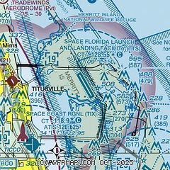
|
| Airport distance calculator |
|---|
|
|
| Sunrise and sunset |
|---|
|
Times for 16-May-2026
| | Local
(UTC-4) | | Zulu
(UTC) |
|---|
| Morning civil twilight | | 06:07 | | 10:07 |
| Sunrise | | 06:32 | | 10:32 |
| Sunset | | 20:06 | | 00:06 |
| Evening civil twilight | | 20:32 | | 00:32 |
|
| Current date and time |
|---|
| Zulu (UTC) | 16-May-2026 08:00:10 |
|---|
| Local (UTC-4) | 16-May-2026 04:00:10 |
|---|
|
| METAR |
|---|
| KTTS | 160655Z AUTO 12004KT 10SM CLR 25/22 A3004 RMK AO2 SLP177 T02510218 $
|
KTIX
8nm SW | 160047Z 09008KT 7SM SCT021 28/22 A3006
|
KXMR
12nm SE | 160655Z AUTO 13007KT 10SM CLR 26/22 A3002 RMK AO2 SLP169 T02580216 $
|
|
| TAF |
|---|
KTIX
8nm SW | 160520Z 1606/1706 10008KT P6SM FEW060 FM161200 12012KT P6SM SCT030 FM161700 11012G22KT P6SM SCT040 FM170200 12009KT P6SM SCT025 SCT250 AMD NOT SKED TIL 161100
|
|
| NOTAMs |
|---|
NOTAMs are issued by the DoD/FAA and will open in a separate window not controlled by AirNav.
|
|


