FAA INFORMATION EFFECTIVE 30 OCTOBER 2025
Location
| FAA Identifier: | UUU |
| Lat/Long: | 41-31-56.7831N 071-16-53.5582W
41-31.946385N 071-16.892637W
41.5324398,-71.2815439
(estimated) |
| Elevation: | 171.8 ft. / 52.4 m (surveyed) |
| Variation: | 15W (1995) |
| From city: | 2 miles NE of NEWPORT, RI |
| Time zone: | UTC -5 (UTC -4 during Daylight Saving Time) |
| Zip code: | 02842 |
Airport Operations
| Airport use: | Open to the public |
| Activation date: | 01/1947 |
| Control tower: | no |
| ARTCC: | BOSTON CENTER |
| FSS: | BRIDGEPORT FLIGHT SERVICE STATION |
| NOTAMs facility: | UUU (NOTAM-D service available) |
| Attendance: | MAY-SEP SUN-SAT 0800-1800, OCT-APR SUN-SAT 0800-1600 |
| Wind indicator: | lighted |
| Segmented circle: | yes |
| Lights: | ACTVT REIL RWY 22; PAPI RWY 22, VASI RWY 4 & 16; MIRL RWY 04/22 & 16/34; TWY A, B, C & RAMP AREA - CTAF. |
| Beacon: | white-green (lighted land airport)
Operates sunset to sunrise. |
| Landing fee: | yes, OVNGT PRKG FEE. LDG FEE COML & NON RHODE ISLAND REG ACFT. |
| International operations: | customs landing rights airport |
Airport Communications
| CTAF/UNICOM: | 123.05 |
| WX ASOS: | 132.075 (401-846-5910) |
| PROVIDENCE APPROACH: | 128.7 |
| PROVIDENCE DEPARTURE: | 128.7 |
| CLEARANCE DELIVERY: | 127.25 |
| WIPOR STAR: | 123.675 |
| WX AWOS-3PT at OQU (7 nm NW): | 118.6 (401-294-2197) |
| WX ASOS at PVD (13 nm NW): | 124.2 (401-734-2818) |
| WX ASOS at EWB (17 nm NE): | 126.85 (508-992-0195) |
- APCH/DEP SVC PRVDD BY BOSTON ARTCC ON FREQS 124.85/307.9 (WOODSTOCK RCAG) WHEN PROVIDENCE APCH CTL CLSD.
Nearby radio navigation aids
| VOR radial/distance | | VOR name | | Freq | | Var |
|---|
| PVDr164/13.3 | | PROVIDENCE VOR/DME | | 115.60 | | 14W |
| SEYr046/25.6 | | SANDY POINT VOR/DME | | 117.80 | | 15W |
| MVYr300/31.2 | | MARTHAS VINEYARD VOR/DME | | 114.50 | | 15W |
| ORWr107/32.3 | | NORWICH VOR/DME | | 110.00 | | 14W |
| PUTr149/35.8 | | PUTNAM VOR/DME | | 117.40 | | 14W |
| GONr085/36.7 | | GROTON VOR/DME | | 110.85 | | 14W |
Airport Services
| Fuel available: | 100LL JET-A
100LL:FUEL AVBL 24 HRS BY CREDIT CARD. |
| Parking: | hangars and tiedowns |
| Airframe service: | MAJOR |
| Powerplant service: | MAJOR |
| Bottled oxygen: | NONE |
| Bulk oxygen: | NONE |
Runway Information
Runway 4/22
| Dimensions: | 2999 x 75 ft. / 914 x 23 m |
| Surface: | asphalt, in fair condition |
| Weight bearing capacity: | |
| Runway edge lights: | medium intensity |
| RUNWAY 4 | | RUNWAY 22 |
| Latitude: | 41-31.654975N | | 41-32.106692N |
| Longitude: | 071-16.983290W | | 071-16.717943W |
| Elevation: | 148.3 ft. | | 171.8 ft. |
| Traffic pattern: | left | | left |
| Runway heading: | 039 magnetic, 024 true | | 219 magnetic, 204 true |
| Markings: | basic, in fair condition | | nonprecision, in fair condition |
| Visual slope indicator: | 4-box VASI on left (4.00 degrees glide path)
OTS UFN. | | 4-light PAPI on left (4.00 degrees glide path) |
| Runway end identifier lights: | no | | yes |
| Touchdown point: | yes, no lights | | yes, no lights |
| Instrument approach: | | | LOC/DME |
| Obstructions: | 75 ft. trees, 1250 ft. from runway, 20 ft. right of centerline, 14:1 slope to clear
10 FT TREES, 160 FT FM THR, 120 FT R; 20 FT TREES, 100 FT FM THR, 200 FT L. | | 38 ft. trees, 750 ft. from runway, 250 ft. left of centerline, 14:1 slope to clear |
Runway 16/34
| Dimensions: | 2623 x 75 ft. / 799 x 23 m |
| Surface: | asphalt, in fair condition
NMRS CRACKS FULL WID & LEN. |
| Weight bearing capacity: | |
| Runway edge lights: | medium intensity |
| RUNWAY 16 | | RUNWAY 34 |
| Latitude: | 41-32.195022N | | 41-31.847642N |
| Longitude: | 071-17.111478W | | 071-16.769880W |
| Elevation: | 146.3 ft. | | 162.2 ft. |
| Traffic pattern: | left | | left |
| Runway heading: | 159 magnetic, 144 true | | 339 magnetic, 324 true |
| Displaced threshold: | no | | 250 ft. |
| Markings: | basic, in fair condition | | basic, in fair condition |
| Visual slope indicator: | 4-box VASI on left (3.75 degrees glide path) | | |
| Runway end identifier lights: | no | | no |
| Touchdown point: | yes, no lights | | yes, no lights |
| Obstructions: | 37 ft. trees, 525 ft. from runway, 250 ft. left of centerline, 8:1 slope to clear
10 FT FENCE/TREES 50 FT FM THR, 220 FT L; 10 FT TREES, 190 FT FM THR, 240 FT R. | | 37 ft. trees, 900 ft. from runway, 200 ft. right of centerline, 18:1 slope to clear
29:1 FM DTHR. |
Airport Ownership and Management from official FAA records
| Ownership: | Publicly-owned |
| Owner: | STATE OF RHODE ISLAND
RHODE ISLAND AIRPORT CORPORATION, 2000 POST RD
WARWICK, RI 02886
Phone 401-691-2000 |
| Manager: | IFTIKHAR AHMAD
RHODE ISLAND AIRPORT CORP, 2000 POST RD
WARWICK, RI 02886
Phone 401-691-2000 |
Additional Remarks
| - | DEER & BIRDS ON & INVOF ARPT. |
| - | RWY 04 DSGND CALM WIND RWY. |
| - | RWY CONDS MAY NOT BE MNT OR RPRTD WHEN ARPT IS UNATNDD. ARPT UNATNDD 1800-0700 DLY & SUN-MON. CTC RIAC OPS AT 401-691-2265. |
| - | ARPT LCTD IN NOISE SENSITIVE AREA. POPULATED AREAS TO THE N, S, & E. NOISE ABATEMENT PROCS IN EFCT. CTC AMGR 401-691-2265 FOR MORE INFO. |
| - | PPR FOR JET ACFT. |
| - | HELS REQSTD TO AVOID MAIN TRML RAMP FOR PRKG OR LDG. PLS CTC AMGR. |
| - | SEASONAL BIRD ACTVTY AER 34, CTC AMGR FOR DTLS 401-691-2265. |
| - | 24 HRS ADVN NOTICE RQRD FOR ALL JET A SVCS AFT POSTED BUS HRS. |
| - | FOR CD WHEN APCH CLSD CTC BOSTON ARTCC AT 603-879-6859. |
| - | NMRS UNLGTD OBSTNS UP TO 150 FT AGL SRNDG AIRFIELD. |
| A51-04 | TMPRY DTHR 499 FT. |
Instrument Procedures
NOTE: All procedures below are presented as PDF files. If you need a reader for these files, you should download the free Adobe Reader.NOT FOR NAVIGATION. Please procure official charts for flight.
FAA instrument procedures published for use from 30 October 2025 at 0901Z to 27 November 2025 at 0900Z.
STARs - Standard Terminal Arrivals |
|---|
| WIPOR FOUR (RNAV) | |
download (283KB) |
IAPs - Instrument Approach Procedures |
|---|
| RNAV (GPS) RWY 16 | |
download (252KB) |
| LOC RWY 22 | |
download (284KB) |
| VOR/DME RWY 16 | |
download (263KB) |
| NOTE: Special Alternate Minimums apply | |
download (153KB) |
| NOTE: Special Take-Off Minimums/Departure Procedures apply | |
download (178KB) |
Other nearby airports with instrument procedures:
KOQU - Quonset State Airport (7 nm NW)
KPVD - Rhode Island TF Green International Airport (13 nm NW)
KEWB - New Bedford Regional Airport (17 nm NE)
KTAN - Taunton Municipal Airport/King Field (24 nm NE)
KSFZ - North Central State Airport (25 nm N)
|
|

Road maps at:
MapQuest
Bing
Google
| Aerial photo |
|---|
WARNING: Photo may not be current or correct
 Photo courtesy of AirNav, LLC
Photo taken 24-Aug-2012
looking west.
Photo courtesy of AirNav, LLC
Photo taken 24-Aug-2012
looking west.
Do you have a better or more recent aerial photo of Newport State Airport that you would like to share? If so, please send us your photo.
|
| Sectional chart |
|---|
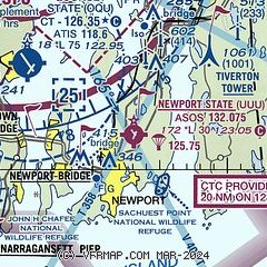
|
CAUTION: Diagram may not be current

| Airport distance calculator |
|---|
|
|
| Sunrise and sunset |
|---|
|
Times for 26-Nov-2025
| | Local
(UTC-5) | | Zulu
(UTC) |
|---|
| Morning civil twilight | | 06:17 | | 11:17 |
| Sunrise | | 06:48 | | 11:48 |
| Sunset | | 16:17 | | 21:17 |
| Evening civil twilight | | 16:48 | | 21:48 |
|
| Current date and time |
|---|
| Zulu (UTC) | 26-Nov-2025 19:29:23 |
|---|
| Local (UTC-5) | 26-Nov-2025 14:29:23 |
|---|
|
| METAR |
|---|
| KUUU | 261853Z AUTO 20006KT 1/4SM FG VV002 13/13 A2973 RMK AO2 SLP067 T01330133
|
KOQU
7nm NW | 261850Z AUTO 19007KT 1SM FG OVC006 A2971 RMK AO2 TEMP/DWPT MISSING
|
KPVD
13nm NW | 261851Z 21008KT 10SM OVC010 15/13 A2973 RMK AO2 SLP066 T01500128
|
KEWB
17nm NE | 261853Z 22006KT 4SM BR OVC003 14/13 A2973 RMK AO2 SLP067 T01390133
|
|
| TAF |
|---|
KPVD
13nm NW | 261756Z 2618/2718 20008KT 6SM BR FEW005 OVC009 FM270000 21006KT 6SM BR FEW005 OVC008 FM270500 25011G18KT P6SM BKN040 FM270700 26012G24KT P6SM SCT250 FM271500 26012G23KT P6SM SCT060
|
|
| NOTAMs |
|---|
NOTAMs are issued by the DoD/FAA and will open in a separate window not controlled by AirNav.
|
|


