FAA INFORMATION EFFECTIVE 09 JULY 2026
Location
| FAA Identifier: | VGC |
| Lat/Long: | 42-50-36.4000N 075-33-40.3000W
42-50.606667N 075-33.671667W
42.8434444,-75.5611944
(estimated) |
| Elevation: | 1136.7 ft. / 346.5 m (surveyed) |
| Variation: | 11W (1980) |
| From city: | 1 mile NW of HAMILTON, NY |
| Time zone: | UTC -4 (UTC -5 during Standard Time) |
| Zip code: | 13346 |
Airport Operations
| Airport use: | Open to the public |
| Activation date: | 01/1963 |
| Control tower: | no |
| ARTCC: | BOSTON CENTER |
| FSS: | BUFFALO FLIGHT SERVICE STATION |
| NOTAMs facility: | BUF (NOTAM-D service available) |
| Attendance: | MAY-SEP MON-SAT 0900-1700, OCT-APR MON-SAT 0900-1700, MAY-SEP SUN 0900-1700, OCT-APR SUN 0900-1700 |
| Wind indicator: | lighted |
| Segmented circle: | yes |
| Lights: | ACTVT MIRL RY 17/35; REIL RYS 17 & 35 - 122.7. |
Airport Communications
| CTAF/UNICOM: | 123.0 |
| WX AWOS-3P: | 119.425 (315-824-1825) |
| SYRACUSE APPROACH: | 126.125 |
| SYRACUSE DEPARTURE: | 126.125 |
| WX AWOS-3 at OIC (17 nm S): | 119.025 (607-336-8583) |
Nearby radio navigation aids
| VOR radial/distance | | VOR name | | Freq | | Var |
|---|
| RKAr339/26.7 | | ROCKDALE VOR/DME | | 112.60 | | 11W |
| SYRr135/34.0 | | SYRACUSE VORTAC | | 117.00 | | 11W |
Airport Services
| Fuel available: | 100LL JET-A JET-A+ |
| Parking: | tiedowns |
| Airframe service: | MAJOR |
| Powerplant service: | MAJOR |
| Bottled oxygen: | NONE |
| Bulk oxygen: | NONE |
Runway Information
Runway 17/35
| Dimensions: | 5314 x 75 ft. / 1620 x 23 m |
| Surface: | asphalt/grooved, in good condition |
| Weight bearing capacity: | | Single wheel: | 20.0 | | Double wheel: | 60.0 |
|
| Runway edge lights: | medium intensity |
| RUNWAY 17 | | RUNWAY 35 |
| Latitude: | 42-51.014082N | | 42-50.198643N |
| Longitude: | 075-33.887160W | | 075-33.456820W |
| Elevation: | 1130.2 ft. | | 1120.8 ft. |
| Traffic pattern: | left | | left |
| Runway heading: | 170 magnetic, 159 true | | 350 magnetic, 339 true |
| Displaced threshold: | 300 ft. | | no |
| Declared distances: | TORA:5314 TODA:5314 ASDA:5314 LDA:5014 | | TORA:5314 TODA:5314 ASDA:5014 LDA:5014 |
| Markings: | nonprecision, in good condition | | nonprecision, in good condition |
| Visual slope indicator: | 2-light PAPI on left (3.00 degrees glide path) | | 2-light PAPI on left (4.00 degrees glide path) |
| Runway end identifier lights: | yes | | yes |
| Touchdown point: | yes, no lights | | yes, no lights |
| Obstructions: | 98 ft. trees, 1786 ft. from runway, 478 ft. left of centerline, 16:1 slope to clear
13 FT BRUSH, 90 FT FM RWY END, 75 - 222 FT RIGHT. | | 33 ft. trees, 848 ft. from runway, 198 ft. right of centerline, 19:1 slope to clear
5 FT. BERM, 109 FT FM THRESHOLD, 179 FT RIGHT. |
Airport Ownership and Management from official FAA records
| Ownership: | Publicly-owned |
| Owner: | VILLAGE OF HAMILTON
PO BOX 119; 3 BROAD ST
HAMILTON, NY 13346
Phone 315-824-6681 |
| Manager: | NANCY MITCHELL
3 BROAD STREET - PO BOX 119
HAMILTON, NY 13346
Phone 315-824-1111 |
Additional Remarks
| - | MIGRATORY BIRDS ON AND INVOF OF ARPT SPRING AND FALL. |
| - | FOR CD CTC SYRACUSE APCH AT 315-455-6218. |
| - | GLDR OPNS INVOF OF ARPT. |
| - | NOISE ABATEMENT PROCEDURES IN EFFECT; ALL ACFT DEPARTURES MAINTAIN RY HEADING UNTIL 2100 FT MSL BEFORE MAKING TURN OUT. |
| - | MAINT SHOP AP & IA AVBL MON-FRI 0900-1700. |
| - | ULTRALGTS ON & INVOF ARPT. |
| - | RY 17/35 SOUTH END HAS 572 FT SAFETY AREA. |
| - | AFT HR FUEL AVAIL. BY APPT FOR A FEE CTC ARPT MGR. |
| - | TAXI SVC AND CAR RENTAL AVBL. |
| - | DEER ON AND INVOF RY 17/35. |
| - | RWY17: WIND MILLS 3 MI N OF ARPT. |
Instrument Procedures
NOTE: All procedures below are presented as PDF files. If you need a reader for these files, you should download the free Adobe Reader.NOT FOR NAVIGATION. Please procure official charts for flight.
FAA instrument procedures published for use from 09 July 2026 at 0901Z to 06 August 2026 at 0900Z.
IAPs - Instrument Approach Procedures |
|---|
| RNAV (GPS) RWY 17 | |
download (190KB) |
| RNAV (GPS) RWY 35 | |
download (240KB) |
| NOTE: Special Take-Off Minimums/Departure Procedures apply | |
download (489KB) |
Other nearby airports with instrument procedures:
KOIC - LT Warren Eaton Airport (17 nm S)
KRME - Griffiss International Airport (24 nm N)
KSYR - Syracuse Hancock International Airport (29 nm NW)
N66 - Albert S Nader Regional Airport (29 nm SE)
N03 - Cortland County Airport-Chase Field (33 nm SW)
|
|

Road maps at:
MapQuest
Bing
Google
| Aerial photo |
|---|
WARNING: Photo may not be current or correct
 Photo by Stephen Taylor
Taken in May 2010
Photo by Stephen Taylor
Taken in May 2010
Do you have a better or more recent aerial photo of Hamilton Municipal Airport that you would like to share? If so, please send us your photo.
|
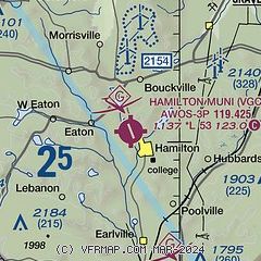
| Sectional chart |
|---|
|
| Airport distance calculator |
|---|
|
|
| Sunrise and sunset |
|---|
|
Times for 21-Jul-2026
| | Local
(UTC-4) | | Zulu
(UTC) |
|---|
| Morning civil twilight | | 05:10 | | 09:10 |
| Sunrise | | 05:43 | | 09:43 |
| Sunset | | 20:34 | | 00:34 |
| Evening civil twilight | | 21:07 | | 01:07 |
|
| Current date and time |
|---|
| Zulu (UTC) | 21-Jul-2026 06:32:47 |
|---|
| Local (UTC-4) | 21-Jul-2026 02:32:47 |
|---|
|
| METAR |
|---|
| KVGC | 210615Z AUTO 14006KT 10SM CLR 16/12 A2988 RMK AO2
|
KOIC
17nm S | 210615Z AUTO 17004KT 10SM FEW055 16/14 A2989 RMK AO2
|
|
| TAF |
|---|
KRME
23nm N | 210541Z 2106/2206 11005KT P6SM BKN200 FM211400 16010G20KT P6SM BKN050 FM211900 20010G20KT 6SM -SHRA BR OVC035 PROB30 2119/2123 3SM -TSRA OVC025CB FM220200 16004KT P6SM BKN025
|
KSYR
29nm NW | 210541Z 2106/2206 16007KT P6SM OVC240 FM211400 18011G21KT P6SM BKN035 FM211800 21010G20KT 6SM -SHRA BR BKN035 PROB30 2119/2123 3SM -TSRA OVC025CB FM212300 20008KT P6SM BKN060 FM220400 22005KT P6SM BKN025
|
|
| NOTAMs |
|---|
NOTAMs are issued by the DoD/FAA and will open in a separate window not controlled by AirNav.
|
|

