FAA INFORMATION EFFECTIVE 27 NOVEMBER 2025
Location
| FAA Identifier: | WDR |
| Lat/Long: | 33-58-57.6830N 083-40-01.9800W
33-58.961383N 083-40.033000W
33.9826897,-83.6672167
(estimated) |
| Elevation: | 934.3 ft. / 284.8 m (surveyed) |
| Variation: | 05W (2010) |
| From city: | 3 miles E of WINDER, GA |
| Time zone: | UTC -5 (UTC -4 during Daylight Saving Time) |
| Zip code: | 30680 |
Airport Operations
| Airport use: | Open to the public |
| Activation date: | 07/1948 |
| Control tower: | no |
| ARTCC: | ATLANTA CENTER |
| FSS: | MACON FLIGHT SERVICE STATION |
| NOTAMs facility: | WDR (NOTAM-D service available) |
| Attendance: | M-F 0900-1800, ALL SUN 1100-1700, ALL SAT 0900-1700 |
| Wind indicator: | lighted |
| Segmented circle: | yes |
| Lights: | HIRL RWY 13/31 PRESET LOW INTST. TO INCREASE INTST & ACTVT MALSR RWY 31; PAPI RWYS 05, 13, 23 & 31; MIRL RWY 05/23; AND TWY LGTS - CTAF. |
| Beacon: | white-green (lighted land airport)
Operates sunset to sunrise. |
Airport Communications
| CTAF/UNICOM: | 123.0 |
| WX AWOS-3: | 118.575 (770-868-0642) |
| ATLANTA APPROACH: | 132.475 ;0615-2200 |
| ATLANTA DEPARTURE: | 132.475 ;0615-2200 |
| WX AWOS-3PT at D73 (12 nm S): | 120.825 (678-635-3668) |
| WX AWOS-3PT at JCA (13 nm NE): | 118.125 (706-387-6477) |
| WX AWOS-3PT at LZU (15 nm W): | PHONE 770-339-7753 |
| WX ASOS at AHN (17 nm E): | 132.875 (706-363-3481) |
| WX ASOS at GVL (19 nm NW): | 126.475 (770-532-4687) |
- APCH/DEP SVC PRVDD BY ATLANTA TRACON 0615-2200 ON FREQS 132.475/291.1 OTHER TIMES BY ATLANTA ARTCC ON FREQS 127.5/316.05 (ATHENS RCAG).
Nearby radio navigation aids
| VOR radial/distance | | VOR name | | Freq | | Var |
|---|
| AHNr277/17.2 | | ATHENS VOR/DME | | 116.95 | | 00E |
| NDB name | | Hdg/Dist | | Freq | | Var | | ID |
|---|
| BARROW COUNTY | | 311/4.8 | | 404 | | 05W | | BMW | -... -- .-- |
| GWNET | | 108/10.0 | | 419 | | 05W | | TX | - -..- |
Airport Services
| Fuel available: | 100LL JET-A+ |
| Parking: | tiedowns |
| Airframe service: | MAJOR |
| Powerplant service: | MAJOR |
| Bottled oxygen: | NONE |
| Bulk oxygen: | NONE |
Runway Information
Runway 13/31
| Dimensions: | 5202 x 100 ft. / 1586 x 30 m |
| Surface: | asphalt, in good condition |
| Weight bearing capacity: | |
| Runway edge lights: | high intensity |
| RUNWAY 13 | | RUNWAY 31 |
| Latitude: | 33-59.288485N | | 33-58.752937N |
| Longitude: | 083-40.367858W | | 083-39.563710W |
| Elevation: | 932.8 ft. | | 907.7 ft. |
| Traffic pattern: | left | | left |
| Runway heading: | 134 magnetic, 129 true | | 314 magnetic, 309 true |
| Displaced threshold: | no | | 602 ft. |
| Declared distances: | TORA:5202 TODA:5202 ASDA:5100 LDA:5100 | | TORA:5202 TODA:5202 ASDA:5202 LDA:4600 |
| Markings: | nonprecision, in fair condition | | precision, in fair condition |
| Visual slope indicator: | 4-light PAPI on left (3.00 degrees glide path) | | 4-light PAPI on left (3.00 degrees glide path) |
| Approach lights: | | | MALSR: 1,400 foot medium intensity approach lighting system with runway alignment indicator lights |
| Runway end identifier lights: | | | no |
| Touchdown point: | yes, no lights | | yes, no lights |
| Instrument approach: | | | ILS/DME |
| Obstructions: | 27 ft. pole, 687 ft. from runway, 366 ft. left of centerline, 18:1 slope to clear
CTLG OBSTN EXCEEDS A 45 DEG SLP. | | 15 ft. rr, 201 ft. from runway, 270 ft. left of centerline
RAILROAD BETWEEN 350-500 FT LEFT FROM 0-200 FT FROM RWY END. TREES 315 FT LEFT AT RWY END. |
Runway 5/23
| Dimensions: | 3607 x 100 ft. / 1099 x 30 m |
| Surface: | asphalt, in fair condition |
| Weight bearing capacity: | |
| Runway edge lights: | medium intensity |
| RUNWAY 5 | | RUNWAY 23 |
| Latitude: | 33-58.668203N | | 33-59.083350N |
| Longitude: | 083-40.385443W | | 083-39.874462W |
| Elevation: | 934.3 ft. | | 916.3 ft. |
| Traffic pattern: | left | | left |
| Runway heading: | 051 magnetic, 046 true | | 231 magnetic, 226 true |
| Markings: | nonprecision, in fair condition | | nonprecision, in fair condition |
| Visual slope indicator: | 2-light PAPI on left (3.00 degrees glide path) | | 2-light PAPI on left (3.00 degrees glide path) |
| Touchdown point: | yes, no lights | | yes, no lights |
| Obstructions: | 46 ft. trees, 1067 ft. from runway, 313 ft. right of centerline, 18:1 slope to clear | | 38 ft. trees, 642 ft. from runway, 313 ft. left of centerline, 11:1 slope to clear |
Airport Ownership and Management from official FAA records
| Ownership: | Publicly-owned |
| Owner: | BARROW COUNTY ARPT AUTH.
841 RONALD WOOD ROAD
WINDER, GA 30680
Phone 770-307-3013 |
| Manager: | STONEY BANGERT
841 RONALD WOOD RD
WINDER, GA 30680
Phone 770-307-3013 |
Additional Remarks
| - | DEER ON AND INVOF ARPT. |
| - | CTC NG OPS 242.4. |
| - | FOR CD CTC ATLANTA APCH AT 678-346-6131, WHEN APCH CLSD CTC ATLANTA ARTCC AT 770-210-7696. |
| - | MAX CLIMB, TURN OUT EARLIER IF POSS TO MINIMIZE NOISE OVER RESIDENTIAL AREAS. |
Instrument Procedures
NOTE: All procedures below are presented as PDF files. If you need a reader for these files, you should download the free Adobe Reader.NOT FOR NAVIGATION. Please procure official charts for flight.
FAA instrument procedures published for use from 27 November 2025 at 0901Z to 25 December 2025 at 0900Z.
IAPs - Instrument Approach Procedures |
|---|
| ILS OR LOC RWY 31 | |
download (283KB) |
| RNAV (GPS) RWY 13 | |
download (209KB) |
| RNAV (GPS) RWY 23 | |
download (232KB) |
| RNAV (GPS) RWY 31 | |
download (241KB) |
| NDB RWY 31 | |
download (207KB) |
| NOTE: Special Alternate Minimums apply | |
download (153KB) |
| NOTE: Special Take-Off Minimums/Departure Procedures apply | |
download (189KB) |
Other nearby airports with instrument procedures:
D73 - Cy Nunnally Memorial Airport (12 nm S)
KJCA - Jackson County Airport (13 nm NE)
KLZU - Gwinnett County Airport-Briscoe Field (15 nm W)
KAHN - Athens/Ben Epps Airport (17 nm E)
KGVL - Lee Gilmer Memorial Airport (19 nm NW)
|
|

Road maps at:
MapQuest
Bing
Google
| Aerial photo |
|---|
WARNING: Photo may not be current or correct
 Photo courtesy of AirNav, LLC
Photo taken 26-Nov-2017
looking northeast.
Photo courtesy of AirNav, LLC
Photo taken 26-Nov-2017
looking northeast.
Do you have a better or more recent aerial photo of Barrow County Airport that you would like to share? If so, please send us your photo.
|
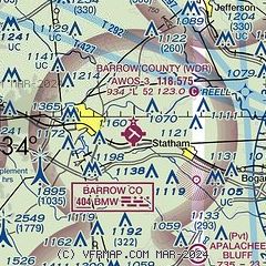
| Sectional chart |
|---|
|
CAUTION: Diagram may not be current

| Airport distance calculator |
|---|
|
|
| Sunrise and sunset |
|---|
|
Times for 08-Dec-2025
| | Local
(UTC-5) | | Zulu
(UTC) |
|---|
| Morning civil twilight | | 07:01 | | 12:01 |
| Sunrise | | 07:29 | | 12:29 |
| Sunset | | 17:25 | | 22:25 |
| Evening civil twilight | | 17:52 | | 22:52 |
|
| Current date and time |
|---|
| Zulu (UTC) | 08-Dec-2025 10:49:55 |
|---|
| Local (UTC-5) | 08-Dec-2025 05:49:55 |
|---|
|
| METAR |
|---|
| KWDR | 081035Z 4SM -DZ SCT003 OVC007 03/03 A3002 RMK AO2
|
KD73
12nm S | 081035Z AUTO 5SM HZ OVC004 05/ A3001 RMK AO2 T0047////
|
KJCA
13nm NE | 081035Z AUTO 00000KT 3SM BR BKN004 OVC009 04/ A3000 RMK AO2 T0040////
|
KLZU
15nm W | 080956Z AUTO 00000KT 5SM -RA BR BKN004 OVC060 05/05 A2999 RMK AO2 CIG 003V007 SLP170 P0001 T00500050 $
|
KAHN
17nm E | 081014Z AUTO 00000KT 5SM -RA BR OVC004 05/04 A2999 RMK AO2 P0000 T00500044
|
KGVL
19nm NW | 081034Z AUTO 25003KT 5SM BR OVC004 04/03 A3000 RMK AO2 RAE14 PRESRR P0000 T00440033 $
|
|
| TAF |
|---|
KAHN
17nm E | 081011Z 0810/0906 30002KT 3SM -RA BR BKN003 OVC006 FM081100 31002KT 6SM BR BKN004 OVC010 FM081300 31004KT P6SM BKN005 OVC012 FM081600 32006KT P6SM BKN015 OVC025 FM081800 32007KT P6SM BKN025 BKN035 FM090000 35005KT P6SM SCT008 BKN015 FM090400 03003KT P6SM BKN008
|
|
| NOTAMs |
|---|
NOTAMs are issued by the DoD/FAA and will open in a separate window not controlled by AirNav.
|
|


