FAA INFORMATION EFFECTIVE 11 JUNE 2026
Location
| FAA Identifier: | LXN |
| Lat/Long: | 40-47-25.5250N 099-46-33.2910W
40-47.425417N 099-46.554850W
40.7904236,-99.7759142
(estimated) |
| Elevation: | 2412.6 ft. / 735.4 m (surveyed) |
| Variation: | 07E (2005) |
| From city: | 2 miles NW of LEXINGTON, NE |
| Time zone: | UTC -5 (UTC -6 during Standard Time) |
| Zip code: | 68850 |
Airport Operations
| Airport use: | Open to the public |
| Activation date: | 01/1946 |
| Control tower: | no |
| ARTCC: | DENVER CENTER |
| FSS: | COLUMBUS FLIGHT SERVICE STATION |
| NOTAMs facility: | LXN (NOTAM-D service available) |
| Attendance: | MON-FRI 0800-1700, ALL SAT 0800-1200 |
| Wind indicator: | yes |
| Segmented circle: | no |
| Lights: | ACTVT REIL RY 14/32; MIRL RY 14/32; PAPI RYS 14/32 - CTAF. |
| Beacon: | white-green (lighted land airport)
Operates sunset to sunrise. |
Airport Communications
| CTAF/UNICOM: | 123.0 |
| WX AWOS-3: | 121.025 (308-324-5975) |
- APCH/DEP CTL SVC PRVDD BY DENVER ARTCC (ZDV) ON FREQS 132.7/226.675 (GRAND ISLAND WEST RCAG).
Nearby radio navigation aids
| VOR radial/distance | | VOR name | | Freq | | Var |
|---|
| OZBr106/(11.4) | | COZAD VOR | | 109.00 | | 09E |
| EARr271/(35.2) | | KEARNEY VOR | | 111.20 | | 05E |
Airport Services
| Fuel available: | 100LL JET-A+
A+:SELF SVC FUEL AVBL 24 HRS WITH CREDIT CARD. |
| Parking: | hangars and tiedowns |
| Airframe service: | MAJOR |
| Powerplant service: | MAJOR |
| Bottled oxygen: | NONE |
| Bulk oxygen: | NONE |
Runway Information
Runway 14/32
| Dimensions: | 5489 x 100 ft. / 1673 x 30 m |
| Surface: | concrete, in good condition |
| Weight bearing capacity: | |
| Runway edge lights: | medium intensity |
| RUNWAY 14 | | RUNWAY 32 |
| Latitude: | 40-47.820883N | | 40-47.097950N |
| Longitude: | 099-46.993050W | | 099-46.279167W |
| Elevation: | 2412.6 ft. | | 2403.3 ft. |
| Traffic pattern: | left | | left |
| Runway heading: | 136 magnetic, 143 true | | 316 magnetic, 323 true |
| Markings: | nonprecision, in good condition | | nonprecision, in good condition |
| Visual slope indicator: | 2-light PAPI on left (3.00 degrees glide path) | | 2-light PAPI on left (3.00 degrees glide path) |
| Runway end identifier lights: | yes | | yes |
| Touchdown point: | yes, no lights | | yes, no lights |
Runway 1/19
| Dimensions: | 3200 x 250 ft. / 975 x 76 m |
| Surface: | turf, in fair condition |
| RUNWAY 1 | | RUNWAY 19 |
| Latitude: | 40-47.117050N | | 40-47.617050N |
| Longitude: | 099-46.523667W | | 099-46.306983W |
| Elevation: | 2400.0 ft. | | 2406.0 ft. |
| Traffic pattern: | left | | left |
| Runway heading: | 011 magnetic, 018 true | | 191 magnetic, 198 true |
| Touchdown point: | yes, no lights | | yes, no lights |
Airport Ownership and Management from official FAA records
| Ownership: | Publicly-owned |
| Owner: | LEXINGTON AIRPORT AUTHORITY
P.O. BOX 972
LEXINGTON, NE 68850-0972
Phone 308-324-8770 |
| Manager: | NATHAN MASTEN
1501 NORTH AIRPORT ROAD
LEXINGTON, NE 68850-3471
Phone 308-324-8770 |
Additional Remarks
| A52-19 | CROPS MAY BE CTLG OBS DURING GROWING SEASON IN THE APCH. |
| - | RY 01/19 NOT PLOWED WINTER MONTHS. |
| - | FOR CD CTC DENVER ARTCC AT 303-651-4257. |
Instrument Procedures
NOTE: All procedures below are presented as PDF files. If you need a reader for these files, you should download the free Adobe Reader.NOT FOR NAVIGATION. Please procure official charts for flight.
FAA instrument procedures published for use from 11 June 2026 at 0901Z to 09 July 2026 at 0900z.
IAPs - Instrument Approach Procedures |
|---|
| RNAV (GPS) RWY 14 | |
download (195KB) |
| RNAV (GPS) RWY 32 | |
download (244KB) |
| NOTE: Special Alternate Minimums apply | |
download (139KB) |
| NOTE: Special Take-Off Minimums/Departure Procedures apply | |
download (353KB) |
Other nearby airports with instrument procedures:
KCZD - Cozad Municipal Airport (11 nm NW)
KGTE - Gothenburg Municipal Airport (19 nm NW)
KHDE - Brewster Field Airport (29 nm SE)
47V - Curtis Municipal Airport (33 nm W)
KCSB - Cambridge Municipal Airport (34 nm SW)
|
|

Road maps at:
MapQuest
Bing
Google
| Aerial photo |
|---|
WARNING: Photo may not be current or correct

Do you have a better or more recent aerial photo of Jim Kelly Field Airport that you would like to share? If so, please send us your photo.
|
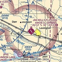
| Sectional chart |
|---|
|
| Airport distance calculator |
|---|
|
|
| Sunrise and sunset |
|---|
|
Times for 16-Jun-2026
| | Local
(UTC-5) | | Zulu
(UTC) |
|---|
| Morning civil twilight | | 05:35 | | 10:35 |
| Sunrise | | 06:08 | | 11:08 |
| Sunset | | 21:11 | | 02:11 |
| Evening civil twilight | | 21:45 | | 02:45 |
|
| Current date and time |
|---|
| Zulu (UTC) | 16-Jun-2026 19:38:02 |
|---|
| Local (UTC-5) | 16-Jun-2026 14:38:02 |
|---|
|
| METAR |
|---|
| KLXN | 161915Z AUTO 17006KT 10SM CLR 27/10 A2980 RMK AO2 T02660095
|
|
| TAF |
|---|
KEAR
36nm E | 161743Z 1618/1718 19009KT P6SM SCT200 FM170000 17013G20KT P6SM FEW250 FM170300 18017G25KT P6SM FEW120 WS018/19050KT FM170900 22017G25KT P6SM FEW120 WS018/23055KT FM171300 30017G26KT P6SM SKC FM171500 33021G30KT P6SM SKC
|
|
| NOTAMs |
|---|
NOTAMs are issued by the DoD/FAA and will open in a separate window not controlled by AirNav.
|
|

